AVALANCHE WARNING »
Dangerous avalanche conditions are occuring or are imminent.
Backcountry travel in avalanche terrain is not recommended.
|
 |
Notice: The Avalanche Warning has been continued for the Wasatch, Bear River and western Uinta ranges. The combination of strong winds and snow has overloaded preexisting buried weak layers in the snowpack. Large, dangerous human triggered avalanches are likely. Travel in backcountry avalanche terrain is not recommended. |
|
|
BOTTOM LINE
Danger by aspect and elevation on slopes approaching 35° or steeper.
(click HERE for tomorrow's danger rating)
|
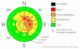
Danger Rose Tutorial
|
There’s a CONSIDERABLE danger in the backcountry today and dangerous avalanche conditions exist on steep slopes with recent deposits of wind-drifted snow. Avalanches on some slopes may step down into old buried weak layers.
Avoid steep slopes and obvious or historic avalanche terrain and use conservative decision making, careful route finding, and good travel habits. Training and experience are essential in the backcountry today.
|
|
|
CURRENT CONDITIONS |

|
Expect a cold, snowy, and breezy day in the mountains. Mountain temperatures are near or below zero this morning, and are forecast to rise to only around 10 degrees at 8500'. Westerly winds will increase again, likely causing continued significant drifting in the light density new powder. Showery snowfall should continue at higher elevations and a couple inches of accumulation is not out of the question...
The mountains around Logan picked up over three inches of water equivalent in the past week, much of this in the form of light powder. The Franklin Basin Snotel reports a foot of new snow from yesterday containing 7/10ths of an inch of water, while the Tony Grove site reports 6 inches with 6/10ths of an inch of water and just over 40 inches of total snow on the ground. ...Go figure...Looks like we got the same amount of new snow or more down here in Logan...
Overnight northwesterly winds at the Campbell Scientific weather station on Logan Peak averaged around 20 mph, with gusts in the 30s, and it's a bone chilling -3 degrees at 9400'
The Tony Grove Road is not maintained for wheeled vehicles this time of year, and you should not try to drive up it without a shovel...Word is, that Beaver plans to open on Monday. Ted doesn't mind a little help packing down the slopes, but the unopened area should still be treated as backcountry. A hike on the familiar runs of the Beav might offer you a safer and more easily accessable option this weekend. Riding conditions have improved drastically with this week's snow. But, due to the danger of tagging a shallowly buried rock and uncertain avalanche conditions, most people I've talked to are sticking to the deep powder in the low angle meadows and avoiding bigger, steeper hills..... |
|
|
RECENT ACTIVITY |

|
Significant natural and human triggered avalanches continue to plague the Central and Southern Wasatch Range and the list of recent backcountry avalanches in the Salt Lake and Park City areas is staggering. (see Wasatch avalanche list).
Yesterday, we were able to trigger a couple small soft slabs on a test slope. These were around a foot deep, failing on weak surface snow formed earlier in the week. Last weekend, skiers triggered a couple avalanches in the Logan Area Backcountry, (photos), but I've not observed any, and no avalanches were reported locally since then...
It's only a matter of time (and weight) before we start seeing dangerous and large avalanches breaking into old snow in some areas..... |
|
|
THREAT #1 |

|
| WHERE |
PROBABILITY |
SIZE |
TREND |

|
|
|
|
| |
|
|
Over the next
24
hours.
|
|
|
Strong pre-frontal southwest winds yesterday built tricky wind-slabs in exposed terrain, mainly on north and east facing slopes. Some of these now sit atop weak layer consisting of surface hoar or frost crystals formed during Tuesday and Wednesday nights under clear cold weather conditions. These wind slabs are now buried by yesterday's nice light powder.
Increasing west winds today will continue to build fresh wind slabs today. Watch for areas with drifts of smooth stiffer, wind deposited snow especially in and around terrain features like gullies, cliff bands or roll-offs. |
|
|
THREAT #2 |

|
| WHERE |
PROBABILITY |
SIZE |
TREND |

|
|
|
|
| |
|
|
Over the next
24
hours.
|
|
|
It's only a matter of time (and weight) before we start seeing dangerous and large avalanches breaking into old snow in some areas.....
Yesterday's snow and strong winds overloaded both buried and surface weak layers. I noted weak snowpack structure at mid-elevations this week, and the mid-November rain-crust, which is currently "bridging" the building slab over extremely weak faceted snow, appears to be deteriorating somewhat, especially in areas with shallow snow cover. Hard to predict exactly when, but avalanches on some slopes may break into older snow layers with the additional load . |
|
|
MOUNTAIN WEATHER |

|
Watch your partners for signs of frostbite today, especially in windy areas. A chilly, moist, arctic weather pattern will continue today and west winds will increase a bit. Expect high temperatures only near 10 degrees at 8500'. Temperatures will warm a bit, (to around 20 degrees), under a short-lived ridge tomorrow ahead of the next quick hitting Pacific storm, which will affect the region on Monday. |
|
|
GENERAL ANNOUNCEMENTS |
The major access to upper elevation snow is via the Tony Grove Road, which is not maintained for wheeled vehicles in the winter. It is however, heavily used by different wintertime user groups, and this time of year patience and restrained speeds in congested areas are important safety concerns....
If you have observations from the backcountry, especially if you see or trigger an avalanche, please let us know. You can leave a message at (435) 755-3638 or 1-800-662-4140, or email us at uac@utahavalanchecenter.org. (Fax 801-524-6301).
The UAC depends on contributions from users like you to support our work. To find out more about how you can support our efforts to continue providing the avalanche forecasting and education that you expect please visit our Friends page.
The information in this advisory is from the U.S.D.A. Forest Service, which is solely responsible for its content. This advisory describes general avalanche conditions and local variations always occur. |
|
|
This information does not apply to developed ski areas or highways where avalanche control is normally done. This advisory is from the U.S.D.A. Forest Service, which is solely responsible for its content. This advisory describes general avalanche conditions and local variations always occur. |
|
This advisory provided by the USDA Forest Service, in partnership with:
The Friends of the Utah Avalanche Center, Utah Division of State Parks and Recreation, Utah Division of Emergency Management, Salt Lake County, Salt Lake Unified Fire Authority and the friends of the La Sal Avalanche Center. See our Sponsors Page for a complete list. |
