AVALANCHE WARNING »
Dangerous avalanche conditions are occuring or are imminent.
Backcountry travel in avalanche terrain is not recommended.
|
 |
Notice: There are already dangerous avalanche conditions in the backcountry today....Heavy snowfall and very strong winds will cause the danger to increase and become more widespread throughout the day. Both human triggered and natural avalanches are becoming more likely. Avoid and stay out from under steep slopes and obvious or historic avalanche paths..... |
|
|
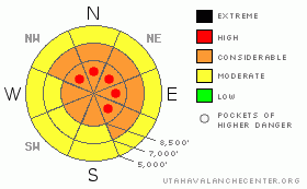
BOTTOM LINE
Danger by aspect and elevation on slopes approaching 35° or steeper.
(click HERE for tomorrow's danger rating)
|
Danger Rose Tutorial
|
There’s a CONSIDERABLE danger in the backcountry today and dangerous avalanche conditions exist on steep slopes with recent deposits of wind-drifted snow. With strong winds and heavy snowfall in the forecast for throughout the day, avalanche conditions will get more dangerous and the problems will become more widespread. The danger is likely to rise to HIGH in some areas by this afternoon. You are likely to trigger avalanches if you venture into steep drifted terrain today, and significant natural avalanches may occur overnight. |
|
|
CURRENT CONDITIONS |

|
Hold on to your hats! Southwest winds are cranking in the high country, with the CSI Logan Peak weather station reporting 35 mph hourly averages and gusts up to 60 mph already early this morning...The strong winds are not restricted to high elevations this morning. The wind-chimes on my front porch are ringing the discordant alarm. The winds will intensify still more with the approach and passage of an energetic cold-front today.
I'd expect a good amount of drifting occurred overnight, given all the nice light powder on the surface we've been finding this week. The Tony Grove Snotel reports around an inch of accumulation overnight and just under 35 inches of total snow on the ground. We've picked up close to 2.5 inches of water equivalent in the past week, much of this in the form of light powder. The strong winds are now building tricky wind-slabs in exposed terrain, and the avalanche danger is already increasing on many slopes.
The Tony Grove Road is not maintained for wheeled vehicles this time of year, and you should not try to drive up it without a shovel...Word is, that Beaver plans to open on Monday. Ted doesn't mind a little help packing down the slopes, but the unopened area should still be treated as backcountry. A hike on the familiar runs of the Beav might offer you a safer and more easily accessable option this weekend. Riding conditions have improved drastically with this week's snow. But, due to the danger of tagging a shallowly buried rock and uncertain avalanche conditions, most people I've talked to are sticking to the deep powder in the low angle meadows and avoiding bigger, steeper hills..... |
|
|
RECENT ACTIVITY |

|
Significant natural and human triggered avalanches continue to plague the Central and Southern Wasatch Range and the list of recent backcountry avalanches in the Salt Lake and Park City areas is staggering. (see Wasatch avalanche list).
Last weekend, skiers triggered a couple avalanches in the Logan Area Backcountry, (photos), but I've not observed any, and no avalanches were reported locally since then... |
|
|
THREAT #1 |

|
| WHERE |
PROBABILITY |
SIZE |
TREND |
|
|
|
|
| |
|
|
Over the next
24
hours.
|
|
|
Strong southwest winds and lots of transportable snow on the suface means rapidly building ridge-top cornices and big wind slabs. Watch for areas with drifts of smooth stiffer, wind deposited snow especially in and around terrain features like gullies, cliff bands or roll-offs. Expect drifting to continue and become even more of a factor as the day progresses.
Heavy snowfall will likely occur while the wind is still cranking today, so extensive loading is likely over large areas, even well below ridge-lines... |
|
|
THREAT #2 |

|
| WHERE |
PROBABILITY |
SIZE |
TREND |

|
|
|
|
| |
|
|
Over the next
24
hours.
|
|
|
Today's forecast heavy snow and strong winds will overload both buried and surface weak layers. Yesterday I noted weak snowpack structure at mid-elevations, and the mid-November rain-crust, which is currently "bridging" the building slab over extremely weak faceted snow, appears to be deteriorating somewhat, especially in areas with shallow snow cover. Hard to predict, but avalanches may break into older snow layers with today's additional load on some slopes.
I also noted well developed surface hoar or frost crystals on the snow surface, which once buried is a notorious weak layer. |
|
|
MOUNTAIN WEATHER |

|
The National Weather Service has issued a Winter Storm Warning through midday Saturday. Heavy snowfall and strong winds are expected.....The storm will usher in some very cold temperatures for the weekend. Another strong storm is expected to begin to effect the region late Sunday......And, yet another is expected to follow for around Christmas. |
|
|
GENERAL ANNOUNCEMENTS |
The major access to upper elevation snow is via the Tony Grove Road, which is not maintained for wheeled vehicles in the winter. It is however, heavily used by different wintertime user groups, and this time of year patience and restrained speeds in congested areas are important safety concerns....
If you have observations from the backcountry, especially if you see or trigger an avalanche, please let us know. You can leave a message at (435) 755-3638 or 1-800-662-4140, or email us at uac@utahavalanchecenter.org. (Fax 801-524-6301).
The UAC depends on contributions from users like you to support our work. To find out more about how you can support our efforts to continue providing the avalanche forecasting and education that you expect please visit our Friends page.
The information in this advisory is from the U.S.D.A. Forest Service, which is solely responsible for its content. This advisory describes general avalanche conditions and local variations always occur. |
|
|
This information does not apply to developed ski areas or highways where avalanche control is normally done. This advisory is from the U.S.D.A. Forest Service, which is solely responsible for its content. This advisory describes general avalanche conditions and local variations always occur. |
|
This advisory provided by the USDA Forest Service, in partnership with:
The Friends of the Utah Avalanche Center, Utah Division of State Parks and Recreation, Utah Division of Emergency Management, Salt Lake County, Salt Lake Unified Fire Authority and the friends of the La Sal Avalanche Center. See our Sponsors Page for a complete list. |
