SPECIAL ANNOUNCEMENT |
 |
I will give a free avalanche awareness talk tonight at 6:30 at the Logan Ranger District Offices (1500 E. 400 N.) in Logan. Everyone is invited...... |
|
|
BOTTOM LINE
Danger by aspect and elevation on slopes approaching 35° or steeper.
(click HERE for tomorrow's danger rating)
|
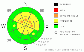
Danger Rose Tutorial
|
There’s a MODERATE danger on most steep slopes in the backcountry. This means that dangerous avalanche conditions exist in some areas, and you could trigger persistent or wind slab avalanches in the 1' to 3' deep range on slopes steeper than about 35 degrees. In some areas, there may be pockets where the danger is CONSIDERABLE, mainly on steep previously drifted slopes in exposed upper elevation terrain. Use conservative decision making, careful route finding, and good travel habits. |
|
|
CURRENT CONDITIONS |

|
Regional 8000' Snotel sites report five new inches of nice light snow from Tuesday. The Tony Grove site reports 4/10ths of an inch of water gain and just under 40" of total snow on the ground. Overnight soutwesterly winds at the Campbell Scientific weather station at 9400' on Logan Peak averaged a bit over 20 mph, with a gust of 32 mph early this morning. This doesn't seem like high winds, but considering how light yesterday's surface snow was, I'd bet there was and is plenty of drifting continuing in exposed terrain...
You'll find deep "cold smoke" powder conditions at mid and upper elevations, if you're able to get up there. Snowmobilers will find plenty of challenging "over the head " riding opportunities on mountain roads, upper elevation meadows, and on lower angled hills. I'm still avoiding the bigger, steeper hills due to lurking avalanche danger and the possibility of tagging a shallowly buried rock.....
Remember, the Tony Grove Road not maintained for driving in the winter. It is now getting a bit sketchy for wheeled vehicles, with a couple feet of fresh snow drifted onto the upper reaches. Several people have spent tedious hours digging out stuck rigs in the past few days. |
|
|
RECENT ACTIVITY |

|
Several more scary avalanches were reported from the Central Wasatch Range yesterday, adding to a long list including a couple close calls. In one case from Tuesday, on the Wasatch Crest between Park City and Brighton, a side-hilling rider was knocked off the saddle, taken for a ride, and partially buried while his sled was completely buried by a broad avalanche. Natural and human triggered avalanches have been quite broad, some reported as more than 1000' wide.
Backcountry skiers triggered a few avalanches in the Logan Area last weekend. We've received reports of soft slab avalanches on Sunday in the Garden City Bowl area above Logan Summit and on Saturday in the Miller Bowl area south of Tony Grove Lake. (photos)
You guys tested several suspect, steep, upper elevation slopes yesterday, and no avalanches were observed or reported. On the other hand, the vast majority of terrain in the region has not yet been tracked this season, and dangerous avalanche conditions may well be lurking in some areas..... |
|
|
THREAT #1 |

|
| WHERE |
PROBABILITY |
SIZE |
TREND |
|
|
|
|
| |
|
|
Over the next
48 hours.
|
|
|
Although strengthening by my limited observations, weak preexisting layers consisting of faceted snow just above the stout mid-November rain-crust may continue to be sensitive to human triggers, and persistent slab avalanches in the 1 to 3' deep range are possible on slopes steeper than about 35 degrees.
The November 12/13th rain crust is deteriorating in some places. Creating the potential for avalanches to step way down into very weak faceted snow beneath it, with an additional load. Large collapses were reported on Wednesday in the Ogden Area Mountains, which are a sign that the snowpack in that area may have reached a critical balance. More weight from snowfall and wind-drift accumulations could push many slopes over the edge.... |
|
|
THREAT #2 |

|
| WHERE |
PROBABILITY |
SIZE |
TREND |

|
|
|
|
| |
|
|
Over the next
12 hours.
|
|
|
Fresh wind slabs, built overnight by moderate westerlies drifting Tuesday's light density snow, could be an issue on steep slopes in exposed upper elevation terrain. There is also a possibility that a smaller wind slab avalanche overrunning a slope with buried persistent weak layers could step down into old snow and become much larger and more dangerous.
Intensifying southwesterly winds will cause this danger to increase Thursday afternoon and evening.... |
|
|
MOUNTAIN WEATHER |

|
We should see mostly cloudy conditions, increasing southwest winds, and possible light snow in the mountains today. Southwest winds will continue to intensify overnight, and we may pick up a few more inches of snow. The cold front dropping out of the Northwest will affect tomorrow's weather, with a good shot of snow likely accompanied by fairly strong westerly winds. Another storm, tapping Pacific moisture, will bring a threat for additional significant snowfall on around Monday. |
|
|
GENERAL ANNOUNCEMENTS |
The major access to upper elevation snow is via the Tony Grove Road, which is not maintained for wheeled vehicles in the winter. It is however, heavily used by different wintertime user groups, and this time of year patience and restrained speeds in congested areas are important safety concerns....
If you have observations from the backcountry, especially if you see or trigger an avalanche, please let us know. You can leave a message at (435) 755-3638 or 1-800-662-4140, or email us at uac@utahavalanchecenter.org. (Fax 801-524-6301).
The UAC depends on contributions from users like you to support our work. To find out more about how you can support our efforts to continue providing the avalanche forecasting and education that you expect please visit our Friends page.
The information in this advisory is from the U.S.D.A. Forest Service, which is solely responsible for its content. This advisory describes general avalanche conditions and local variations always occur. |
|
|
This information does not apply to developed ski areas or highways where avalanche control is normally done. This advisory is from the U.S.D.A. Forest Service, which is solely responsible for its content. This advisory describes general avalanche conditions and local variations always occur. |
|
This advisory provided by the USDA Forest Service, in partnership with:
The Friends of the Utah Avalanche Center, Utah Division of State Parks and Recreation, Utah Division of Emergency Management, Salt Lake County, Salt Lake Unified Fire Authority and the friends of the La Sal Avalanche Center. See our Sponsors Page for a complete list. |
