SPECIAL ANNOUNCEMENT |
 |
The National Weather Service has issued a Winter Storm Warning for the entire region through Sunday evening.
Expect heavy snowfall and strong winds, especially in the mountains. With this, the Avalanche Danger in the backcountry is rising significantly....... |
|
|
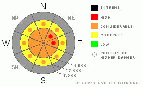
BOTTOM LINE
Danger by aspect and elevation on slopes approaching 35° or steeper.
(click HERE for tomorrow's danger rating)
|
Danger Rose Tutorial
|
There's a CONSIDERABLE danger on steep upper elevation slopes in the backcountry. Continuing heavy snowfall and strong westerly winds will cause avalanches to be more likely and larger, and the danger to be more widespread as snow piles up and overloads weak preexisting layers. This storm will cause dangerous avalanche conditions in the mountains. Use conservative decision making, careful route finding, and good travel habits. Training and experience are essential....
|
|
|
CURRENT CONDITIONS |

|
Serious winter weather is here, and the game is on.....
Even before the arrival of the front, as of 5:00 this morning, the Tony Grove Snotel recorded 7 inches of snow accumulation containing 7/10ths of an inch of water. Expect mountain snowfall rates in the four-inch-an-hour range with frontal passage, dropping to one to two-inches-an-hour later on in the day.
Strong southwest winds are drifting tons of snow at upper elevations. The Campbell Scientific weather station on Logan Peak is recording average wind speeds in the upper 30s (mph) with a recent 76 mph gust. It's currently 19 degrees at 9400' and temperatures are forecast to drop today......... |
|
|
THREAT #1 |

|
| WHERE |
PROBABILITY |
SIZE |
TREND |
|
|
|
|
| |
|
|
Over the next
24
hours.
|
|
|
Heavy snowfall combined with strong westerly winds today will continue to load large quantities of snow over vast lee fetch areas, and rapid loading will affect slopes even well below ridge-lines. Potential avalanches will become more likely and larger, and the danger will become more widespread as snow piles up and overloads weak preexisting layers. faceted crystals and surface hoar |
|
|
THREAT #2 |

|
| WHERE |
PROBABILITY |
SIZE |
TREND |
|
|
|
|
| |
|
|
Over the next
24
hours.
|
|
|
Southwest winds are still increasing in intensity at the Campbell Scientific weather station on Logan Peak, recording average wind speeds near 40 mph and a recent 76 mph gust. These winds must be drifting tons of fresh snow into avalanche starting zones, and building dangerous wind slabs on steep exposed slopes.
We've noted significant lower elevation winds as well, so wind slabs will continue to form in somewhat unexpected places and at lower elevations.... |
|
|
MOUNTAIN WEATHER |

|
The leading edge of the front is just now nosing into the Cache Valley Area, and it's snowing heavily in Logan as I write. Snow will continue to fall heavily today, and westerly winds will remain fairly strong in the mountains as they gradually switch to the northwest. Snowfall will become more terrain limited tonight and tomorrow, but the weather will remain unsettled and productive well into next week. |
|
|
GENERAL ANNOUNCEMENTS |
The major access to upper elevation snow is via the Tony Grove Road, which is not maintained for wheeled vehicles in the winter. It is however, heavily used by different wintertime user groups, and this time of year patience and restrained speeds in congested areas are important safety concerns....
If you have observations from the backcountry, especially if you see or trigger an avalanche, please let us know. You can leave a message at (435) 755-3638 or 1-800-662-4140, or email us at uac@utahavalanchecenter.org. (Fax 801-524-6301).
The UAC depends on contributions from users like you to support our work. To find out more about how you can support our efforts to continue providing the avalanche forecasting and education that you expect please visit our Friends page.
The information in this advisory is from the U.S.D.A. Forest Service, which is solely responsible for its content. This advisory describes general avalanche conditions and local variations always occur. |
|
|
This information does not apply to developed ski areas or highways where avalanche control is normally done. This advisory is from the U.S.D.A. Forest Service, which is solely responsible for its content. This advisory describes general avalanche conditions and local variations always occur. |
|
This advisory provided by the USDA Forest Service, in partnership with:
The Friends of the Utah Avalanche Center, Utah Division of State Parks and Recreation, Utah Division of Emergency Management, Salt Lake County, Salt Lake Unified Fire Authority and the friends of the La Sal Avalanche Center. See our Sponsors Page for a complete list. |
