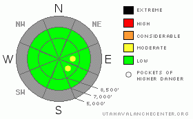
BOTTOM LINE
Danger by aspect and elevation on slopes approaching 35° or steeper.
(click HERE for tomorrow's danger rating)
|
Danger Rose Tutorial
|
The danger is LOW on most slopes in the backcountry, and you will find generally stable snow conditions. Exceptions are pockets with a MODERATE danger at upper elevations. You might trigger wind slab avalanches on isolated exposed slopes steeper than about 35 degrees. The danger will certainly rise and become more widespread tomorrow, with a strong winter storm on our doorstep. |
|
|
CURRENT CONDITIONS |

|
Serious winter weather is on our doorstep, and the game is on.....
There's around two feet of snow at upper elevations in the Bear River Range, and little if any snow cover down low and on south facing slopes. A very solid ice-crust from mid-November is buried by only a few inches of now weakened early December snow. (Photos of Central Bear River Range snow cover)
This will change overnight and the avalanche danger will rise significantly in the backcountry this weekend. The National Weather Service has issued a Winter Storm Watch for the region for late this evening through Saturday night. Expect a good shot of snow and strong winds tomorrow. |
|
|
THREAT #1 |

|
| WHERE |
PROBABILITY |
SIZE |
TREND |
|
|
|
|
| |
|
|
Over the next
24
hours.
|
|
|
Pockety wind slabs developed during the week on upper elevation slopes exposed to wind drifting. Although most of these are now bonded well to the underlying snow, some still may be sensitive to your weight. Most of these are fairly obvious drifts; stiffer snow, smooth , chalky looking, pillow-like, and you should avoid them on steep slopes.
In places, wind slabs built and could fail on a weak layer consisting of last Thursday's light snow, (now small faceted crystals) and graupel... |
|
|
MOUNTAIN WEATHER |

|
A weak storm will affect the region this morning and a much more serious storm will roll in overnight, bringing significant snowfall and strong winds for tomorrow. This storm is the leading edge of a long wave trough, which has the potential to bring a lot of storminess and moisture into Utah in the coming week...A good old snow cycle is what we need, but it looks like it'll come in hard, so you better get on your toes. |
|
|
GENERAL ANNOUNCEMENTS |
The major access to upper elevation snow is via the Tony Grove Road, which is not maintained for wheeled vehicles in the winter. It is however, heavily used by different wintertime user groups, and this time of year patience and restrained speeds in congested areas are important safety concerns....
We plan to run the Basic Avalanche Clinic on December 12-13 with the USU Outdoor Recreation Center. Please register in advance....call (435) 797 - 3264 or go to USU ORC
If you’re getting out and see anything we should know about please let us know. You can leave a message at (435) 755-3638 or 1-800-662-4140, or email us at uac@utahavalanchecenter.org. (Fax 801-524-6301).
The UAC depends on contributions from users like you to support our work. To find out more about how you can support our efforts to continue providing the avalanche forecasting and education that you expect please visit our Friends page.
The information in this advisory is from the U.S. Forest Service, which is solely responsible for its content. This advisory describes general avalanche conditions and local variations always occur. |
|
|
This information does not apply to developed ski areas or highways where avalanche control is normally done. This advisory is from the U.S.D.A. Forest Service, which is solely responsible for its content. This advisory describes general avalanche conditions and local variations always occur. |
|
This advisory provided by the USDA Forest Service, in partnership with:
The Friends of the Utah Avalanche Center, Utah Division of State Parks and Recreation, Utah Division of Emergency Management, Salt Lake County, Salt Lake Unified Fire Authority and the friends of the La Sal Avalanche Center. See our Sponsors Page for a complete list. |
