SPECIAL ANNOUNCEMENT |
 |
The major access to upper elevation snow is via the Tony Grove Road, which is not maintained for wheeled vehicles in the winter. It is however, heavily used by different wintertime user groups, and this time of year patience and restrained speeds in congested areas are important safety concerns....
It was possible and many people drove clear up to the lake last weekend. I expect that by next weekend, we may be forced into parking at lower elevations.... |
|
|
BOTTOM LINE
Danger by aspect and elevation on slopes approaching 35° or steeper.
(click HERE for tomorrow's danger rating)
|
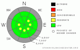
Danger Rose Tutorial
|
There are pockets with a MODERATE danger at upper elevations in the backcountry today, and you could trigger wind slab avalanches on exposed slopes steeper than about 35 degrees. Watch for recently drifted snow on steep, wind exposed slopes and in terrain features like gullies, banks, or hollows. The danger is LOW on most other slopes in the region, and you will find stable snow conditions on lower angled slopes, at mid-elevations, and in more sheltered terrain. |
|
|
CURRENT CONDITIONS |

|
You can find fairly good shallow powder conditions at upper elevations, if you can find slopes that aren't too badly wind hammered. A northerly wind at the CSI weather station on Logan Peak intensified overnight, reading hourly average wind speeds in the 30 mph range for the last 9 hours, with gusts near 50 mph early this morning.
We picked up a nice even blanket of new snow on Monday, with a solid 6 inches accumulating on slopes above around 8000'. There's 23 inches of total snow on the ground at the 8400' Tony Grove Snotel. A stout ice-crust formed in mid-November is still the dominate feature in the snowpack at high elevations, and it is quite shallowly buried or exposed in patches on many steep slopes... |
|
|
THREAT #1 |

|
| WHERE |
PROBABILITY |
SIZE |
TREND |
|
|
|
|
| |
|
|
Over the next
24
hours.
|
|
|
Pockety wind slabs developed on upper elevation slopes exposed to wind drifting and some may be sensitive to your weight. Many of these are now fairly obvious; stiffer snow, smooth , chalky looking, pillow-like. In places, wind slabs built and may fail on a weak layer consisting of last Thursday's light snow, (now small faceted crystals) and graupel... |
|
|
MOUNTAIN WEATHER |

|
We'll be under a northwest flow today, and there is a chance we'll see a few snowflakes in the mountains around Logan. A weak trough may affect the region, bringing a chance of light snowfall late tomorrow and into Friday, but the big change in the weather pattern won't really hit until Saturday, when the leading edge of a deep longwave trough will bring significant snow. Expect continued storminess and significant snow accumulations to continue through much of next week. |
|
|
GENERAL ANNOUNCEMENTS |
We plan to run the Basic Avalanche Clinic on December 12-13 with the USU Outdoor Recreation Center. Please register in advance....call (435) 797 - 3264 or go to USU ORC
If you’re getting out and see anything we should know about please let us know. You can leave a message at (435) 755-3638 or 1-800-662-4140, or email us at uac@utahavalanchecenter.org. (Fax 801-524-6301).
The UAC depends on contributions from users like you to support our work. To find out more about how you can support our efforts to continue providing the avalanche forecasting and education that you expect please visit our Friends page.
The information in this advisory is from the U.S. Forest Service, which is solely responsible for its content. This advisory describes general avalanche conditions and local variations always occur. |
|
|
This information does not apply to developed ski areas or highways where avalanche control is normally done. This advisory is from the U.S.D.A. Forest Service, which is solely responsible for its content. This advisory describes general avalanche conditions and local variations always occur. |
|
This advisory provided by the USDA Forest Service, in partnership with:
The Friends of the Utah Avalanche Center, Utah Division of State Parks and Recreation, Utah Division of Emergency Management, Salt Lake County, Salt Lake Unified Fire Authority and the friends of the La Sal Avalanche Center. See our Sponsors Page for a complete list. |
