BOTTOM LINE
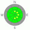
Danger by aspect and elevation on slopes approaching 35° or steeper.
(click HERE for tomorrow's danger rating)
|

Danger Rose Tutorial
|
There are pockets with a MODERATE danger and you could trigger wind slab avalanches on slopes steeper than about 35 degrees in exposed upper elevation terrain. Watch for drifted snow on steep slopes mainly in the lee of the highest ridges, especially near saddle areas, and in terrain features like banks, gullies, or scoops.
There's a LOW danger elsewhere in the backcountry around Logan with generally stable snow conditions. |
|
|
CURRENT CONDITIONS |

|
Northwest winds built substantial drifts and wind slabs in exposed upper elevation terrain with Thursday morning's nice light powder. Conditions are improving for travel, as the solid ice crust from mid-November is now covered up in many areas. Steep slopes are still a bit hard to navigate on since you tend to slip on the shallowly buried ice, and exposed or scoured off patches of ice can throw you around if you're not expecting to go skating down the hill.
Yesterday's northwest wind averaged around 30 mph for several hours with gusts up to 50 mph. |
|
|
RECENT ACTIVITY |

|
A couple skiers reported triggering a sizable cornice fall up on Cornice Ridge. The very sensitive chunk rolled down into the bowl below and broke up on the shallowly buried ice layer. In route to the Cottonwood saddle yesterday, we triggered a number of significant shooting cracks in stiff, freshly formed wind drifts. These were quite sensitive, cracking around terrain features around a foot deep yesterday morning. I expect there are drifts in the 1.5' to 2' deep range in exposed areas today.
We noticed numerous harmless natural loose snow avalanches from Thursday on the steep slopes and cliff bands in the Tony Grove Lake Area. |
|
|
THREAT #1 |

|
| WHERE |
PROBABILITY |
SIZE |
TREND |
|
|
|
|
| |
|
|
Over the next
24
hours.
|
|
|
Watch for pockets of wind deposited or drifted new snow in exposed terrain, mainly along the highest ridges and in lee pockets. I'm mostly concerned by the stiffer wind slabs built yesterday by northwest winds. These may now be 1-2' deep, and once set in motion could pick up speed, running on the slick November rain-crust.
These slabs are probably less sensitive today, but stiff wind slabs can be quite tricky, sometimes allowing you to get well out on them before releasing. |
|
|
MOUNTAIN WEATHER |

|
We'll see a few high clouds and lots of sunshine with warming temperatures today as a high pressure system controls the weather for the weekend. Expect clouds and southwest winds to gradually increase on Sunday ahead of the next quick-hitting storm scheduled for Monday. This storm looks like it could produce around 6 inches of much needed accumulation at upper elevations.
The models are leaning toward a real change in the overall weather pattern near the end of next week... The persistent ridge over the West may finally break down leaving us in a deep trough and perhaps a good old snow cycle. |
|
|
GENERAL ANNOUNCEMENTS |
We plan to run the Basic Avalanche Clinic on December 12-13 with the USU Outdoor Recreation Center. Please register in advance....call (435) 797 - 3264 or go to USU ORC
If you’re getting out and see anything we should know about please let us know. You can leave a message at (435) 755-3638 or 1-800-662-4140, or email us at uac@utahavalanchecenter.org. (Fax 801-524-6301).
The information in this advisory is from the U.S. Forest Service, which is solely responsible for its content. This advisory describes general avalanche conditions and local variations always occur. |
|
|
This information does not apply to developed ski areas or highways where avalanche control is normally done. This advisory is from the U.S.D.A. Forest Service, which is solely responsible for its content. This advisory describes general avalanche conditions and local variations always occur. |
|
This advisory provided by the USDA Forest Service, in partnership with:
The Friends of the Utah Avalanche Center, Utah Division of State Parks and Recreation, Utah Division of Emergency Management, Salt Lake County, Salt Lake Unified Fire Authority and the friends of the La Sal Avalanche Center. See our Sponsors Page for a complete list. |
