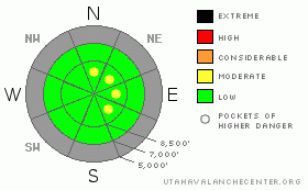
BOTTOM LINE
Danger by aspect and elevation on slopes approaching 35° or steeper.
(click HERE for tomorrow's danger rating)
|
Danger Rose Tutorial
|
There's a LOW danger in the backcountry around Logan with generally stable snow conditions. Exceptions include the potential for mostly harmless loose dry snow avalanches on steep slopes. Also, in exposed terrain there are pockets with a MODERATE danger, where triggering recently deposited wind slabs may be possible. Watch for drifted snow on isolated steep slopes mainly along the highest ridges and in terrain features like gullies or scoops. |
|
|
CURRENT CONDITIONS |

|
Five inches of nice fluffy powder fell with very little wind up at the Tony Grove Snotel yesterday morning, and not being a powder snob this year, I'd have to say I found good snow conditions at upper elevations. It's still quite shallow, but you now ride above or on a very stout crust formed in mid-November. Because of the icy crust, you'll find the best snow conditions on low angled slopes... Mountain temperatures are in the teens this morning and a northwest wind picked up in the last few hours, with the CSI weather station on Logan Peak reading 25 mph average windspeeds. |
|
|
RECENT ACTIVITY |

|
We noticed numerous natural loose snow avalanches on the steep slopes and cliff bands in the Tony Grove Lake Area yesterday morning. The light new snow was moving easily, and we triggered several non-threatening sluffs on scratchy slopes steeper than 35 degrees. |
|
|
THREAT #1 |

|
| WHERE |
PROBABILITY |
SIZE |
TREND |
|
|
|
|
| |
|
|
Over the next
24
hours.
|
|
|
Watch for pockets of wind deposited or drifted new snow in exposed terrain, mainly along the highest ridges and in lee pockets. I'm mostly concerned by stiffer wind slabs built overnight by northwest winds. These may be several inches deep, and once set in motion will likely pick up speed, running on the slick November rain-crust.
Loose powder sluffs may continue to be an issue on steep slopes, but these are fairly harmless unless they start pushing you around. |
|
|
MOUNTAIN WEATHER |

|
We'll see high clouds and sunshine with warming temperatures as a high pressure system moves in for the weekend. Expect clouds and southwest winds to increase on Sunday ahead of the next quick hitting storm scheduled for Sunday night into Monday...
The models hint at a real change in the overall weather pattern near the end of next week... The persistent ridge over the West may finally break down. |
|
|
GENERAL ANNOUNCEMENTS |
We plan to run the Basic Avalanche Clinic on December 12-13 with the USU Outdoor Recreation Center. Please register in advance....call (435) 797 - 3264 or go to USU ORC |
|
|
This information does not apply to developed ski areas or highways where avalanche control is normally done. This advisory is from the U.S.D.A. Forest Service, which is solely responsible for its content. This advisory describes general avalanche conditions and local variations always occur. |
|
This advisory provided by the USDA Forest Service, in partnership with:
The Friends of the Utah Avalanche Center, Utah Division of State Parks and Recreation, Utah Division of Emergency Management, Salt Lake County, Salt Lake Unified Fire Authority and the friends of the La Sal Avalanche Center. See our Sponsors Page for a complete list. |
