BOTTOM LINE
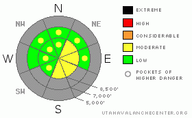
Danger by aspect and elevation on slopes approaching 35° or steeper.
(click HERE for tomorrow's danger rating)
|
Danger Rose Tutorial
|
There is a MODERATE danger of wind slab avalanches at upper elevations in the Logan area backcountry. Watch for recently deposited wind slabs in exposed terrain, mainly along the highest ridges and in terrain features like gullies or scoops.
|
|
|
CURRENT CONDITIONS |

|
Yesterday, a few inches accumulated on upper elevation slopes. Meanwhile, strong west and northwest winds drifted it into lee slope fetch areas or deceleration zones and built wind slabs on some slopes. A couple inches really helped conditions out, but you're still riding on the prominent Mid-November rain crust so low angled slopes are the most fun. The Tony Grove Snotel at 8400' reports 4 inches of settled new snow containing 4/10ths of an inch of water. Overnight northwesterly winds averaged around 15 mph at the Campbell Scientific weather station at 9400' on Logan Peak.
|
|
|
THREAT #1 |

|
| WHERE |
PROBABILITY |
SIZE |
TREND |
|
|
|
|
| |
|
|
Over the next
24
hours.
|
|
|
Watch for wind deposited or drifted new snow in exposed terrain, mainly along the highest ridges and in lee pockets. I'm mostly concerned by stiffer wind slabs built overnight by north northwest winds. These may be several inches deep, and once set in motion will likely pick up speed, running on the slick November rain-crust.
|
|
|
MOUNTAIN WEATHER |

|
Snow showers will likely continue at times today and a cool northwesterly flow will continue. A weak storm will bring us a little more snow overnight and tomorrow before a ridge of high pressure moves in for the weekend. Models are in disagreement beyond this point, but storminess around the first part of next week is a good bet. |
|
|
GENERAL ANNOUNCEMENTS |
We plan to run the Basic Avalanche Clinic on December 12-13 with the USU Outdoor Recreation Center. Please register in advance....call (435) 797 - 3264 or go to USU ORC |
|
|
This information does not apply to developed ski areas or highways where avalanche control is normally done. This advisory is from the U.S.D.A. Forest Service, which is solely responsible for its content. This advisory describes general avalanche conditions and local variations always occur. |
|
This advisory provided by the USDA Forest Service, in partnership with:
The Friends of the Utah Avalanche Center, Utah Division of State Parks and Recreation, Utah Division of Emergency Management, Salt Lake County, Salt Lake Unified Fire Authority and the friends of the La Sal Avalanche Center. See our Sponsors Page for a complete list. |
