BOTTOM LINE
Danger by aspect and elevation on slopes approaching 35° or steeper.
(click HERE for tomorrow's danger rating)
|
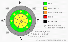
Danger Rose Tutorial
|
Although most slopes in the region are still to shallow to produce significant avalanches, there is a MODERATE danger and avalanches are possible on steep slopes above around 8000' today. Both human triggered and natural loose wet avalanches will become possible on steep slopes with saturated new snow. You also might trigger isolated wind slab avalanches in exposed upper elevation terrain. |
|
|
CURRENT CONDITIONS |

|
You'll find generally shallow snow coverage across the Bear River Range, with only a foot or two at best covering the rocky slopes above around 8500'. Around five inches of heavy snow fell Sunday night and Monday up at Tony Grove Lake. This settled out nicely, and it looks like four or five more inches accumulated overnight at upper elevations. The Snotel at 8400’ shows 4/10ths of an inch of (SWE) overnight with a bit over 15 inches of total snow on the ground containing 2.7 inches of water equivalent. At 5:00 this morning it was already 30 degrees and climbing. Sadly, the rain/snow line will likely climb up to, and potentially above the 8500’ elevation line….. |
|
|
THREAT #1 |

|
| WHERE |
PROBABILITY |
SIZE |
TREND |

|
|
|
|
| |
|
|
Over the next
24
hours.
|
|
|
With warming temperatures, fresh wet snow, and maybe rain, you could trigger loose wet avalanches today on steep slopes with saturated new snow. These might entrain a good amount of mass and be a threat to anyone below. |
|
|
THREAT #2 |

|
| WHERE |
PROBABILITY |
SIZE |
TREND |

|
|
|
|
| |
|
|
Over the next
24
hours.
|
|
|
Freshly formed wind slabs may pose a danger on steep exposed slopes in the highest elevation terrain. Be wary of wind deposits near ridge-lines or saddles and high elevation fetch-areas like gullies or scoops. |
|
|
MOUNTAIN WEATHER |

|
Several more inches of snowfall is a good bet today at high elevations. Unfortunately, the rain line will climb significantly today and things will get pretty wet below at least 8500'. Another, colder front will bring more moisture to the region late Thursday. A high presure system will bring fair weather and lots of sunshine for the weekend. |
|
|
GENERAL ANNOUNCEMENTS |
The Friends of the Utah Avalanche Center in Logan will present the annual fund-raiser party at the Bullen Center on Friday, November 21st. Proceeds will help support your local avalanche center right here in Logan. Hope to see you there. |
|
|
This information does not apply to developed ski areas or highways where avalanche control is normally done. This advisory is from the U.S.D.A. Forest Service, which is solely responsible for its content. This advisory describes general avalanche conditions and local variations always occur. |
|
This advisory provided by the USDA Forest Service, in partnership with:
The Friends of the Utah Avalanche Center, Utah Division of State Parks and Recreation, Utah Division of Emergency Management, Salt Lake County, Salt Lake Unified Fire Authority and the friends of the La Sal Avalanche Center. See our Sponsors Page for a complete list. |
