BOTTOM LINE
Danger by aspect and elevation on slopes approaching 35° or steeper.
(click HERE for tomorrow's danger rating)
|
Danger Rose Tutorial
|
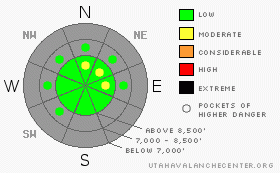
There is generally a LOW danger above around 8500'. This means avalanches are unlikely but not impossible. Watch for potential loose snow avalanches on very steep slopes and developing wind slabs in exposed terrain at the highest elevations. |
|
|
CURRENT CONDITIONS |

|
You'll find generally shallow snow coverage across the Bear River Range, with only a foot to a foot-and-a-half covering the rocky slopes above around 8500'. Around five inches of heavy snow fell Sunday night and Monday up at Tony Grove Lake. There's adequate snow for cross country skiing and snow shoes, but if you want to do some sliding, you'll want to stick to smooth, grassy slopes. There really isn't enough snow yet for snowmobiling, but the season is just around the corner. Now is a good time to make sure all your rescue gear is in order, and it's a good time to get your backcountry partners to practice with their beacons... |
|
|
RECENT ACTIVITY |

|
We noticed evidence of several loose snow avalanches on the very steep slopes just south of Tony Grove Lake. These involved all the fresh new snow and traveled well down into the bowl, knocking down numerous cone flowers in their paths. Otherwise no avalanches have been observed of reported yet this season in the Logan Area Mountains. |
|
|
THREAT #1 |

|
| WHERE |
PROBABILITY |
SIZE |
TREND |

|
|
|
|
| |
|
|
Over the next
24
hours.
|
|
|
With shallow snow across the region, the avalanche danger is generally Low above around 8500'. You might find isolated pockets on very steep slopes where you could trigger loose avalanches. Also be wary as the wind begins to pick up in the next couple days. Freshly formed wind slabs may pose a danger on exposed slopes in the highest elevation terrain. |
|
|
MOUNTAIN WEATHER |

|
Well at least we're not headed into a strong high pressure. Expect cloud cover today and snowfall tonight at upper elevations, with about 5 inches of accumulation possible. More light snow is possible tomorrow, but the rain/snow line will climb to nearly 9000'. Warmth will keep the precipitation on the moist side through the next few days. With rain in the Valley and snow on the mountain tops and a mix everywhere in between. |
|
|
GENERAL ANNOUNCEMENTS |
The Friends of the Utah Avalanche Center in Logan will present the annual fund-raiser party at the Bullen Center on Friday, November 21st. Proceeds will help support your local avalanche center right here in Logan. Hope to see you there. Join us for dinner and a movie this Thursday Nov. 13th at Brewvies Cinema in Salt Lake City for the second annual Boondockers/Thunderstruck premier. Festivities start at 6:30 (food and drink) with the movies rolling at 7:00. Tickets are $10.00 and all proceeds go to the Friends of the UAC for snowmobile specific avalanche awareness programs.Click here for more details and a discount coupon. |
|
|
This information does not apply to developed ski areas or highways where avalanche control is normally done. This advisory is from the U.S.D.A. Forest Service, which is solely responsible for its content. This advisory describes general avalanche conditions and local variations always occur. |
|
This advisory provided by the USDA Forest Service, in partnership with:
The Friends of the Utah Avalanche Center, Utah Division of State Parks and Recreation, Utah Division of Emergency Management, Salt Lake County, Salt Lake Unified Fire Authority and the friends of the La Sal Avalanche Center. See our Sponsors Page for a complete list. |
