25th Annual Black Diamond Fall Fundraising Party
Thursday, September 13; 6:00-10:00 PM; Black Diamond Parking Lot
25th Annual Black Diamond Fall Fundraising Party
Thursday, September 13; 6:00-10:00 PM; Black Diamond Parking Lot
| Advisory: Abajo Area Mountains | Issued by Eric Trenbeath for Tuesday - February 20, 2018 - 7:14am |
|---|

|
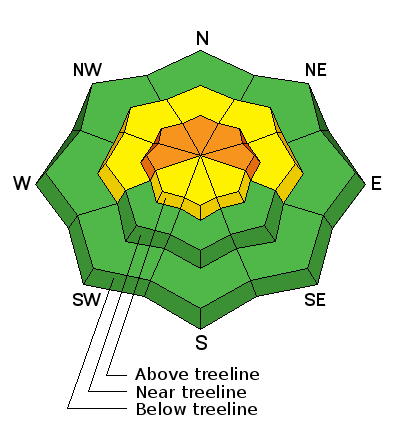
bottom line The avalanche danger is CONSIDERABLE today on steep, upper elevation terrain that faces W-N-E where wind loading has added stress to buried weak layers in the snowpack. At mid elevations the avalanche danger is MODERATE. Low elevation terrain offers mostly LOW danger.
|
 |
special announcement Episode 5 of the UAC podcast "To Hell in a Heartbeat - A Conversation With Tom Diegel and Matt Clevenger About the 12.26.08 Full Burial on Little Water" is live. Matt and Tom talk about the avalanche documented in To Hell in a Heartbeat. Check it out on ITunes, Stitcher, the UAC blog. The UAC Marketplace is still open. Our online marketplace still has deals on skis, packs, airbag packs, beacons, snowshoes, soft goods and much more. |
 |
current conditions It looks like only about 2-4" of snow fell in the Abajos overnight. Southerly winds blew strong most of the day yesterday and then backed off and shifted to westerly. They are currently averaging 10-15 mph along ridge tops. It's a frigid 10 degrees at Buckboard Flat. Wind, temperature and humidity on Abajo Peak (11,000') Snow totals at Buckboard Flat (8924') Snow totals at Camp Jackson (8858') |
| type | aspect/elevation | characteristics |
|---|

|
|
LIKELIHOOD
 LIKELY
UNLIKELY
SIZE
 LARGE
SMALL
TREND
 INCREASING DANGER
SAME
DECREASING DANGER
|
|
description
The snow on the ground is very weak consisting of loose, sugary, faceted snow. The new snow from last week has formed a cohesive layer or slab on top of the old snow. Wind loading yesterda added further stress to the snowpack and human triggered avalanches 1-2' deep are likely on steep, upper elevation terrain that faces NW-N-E.
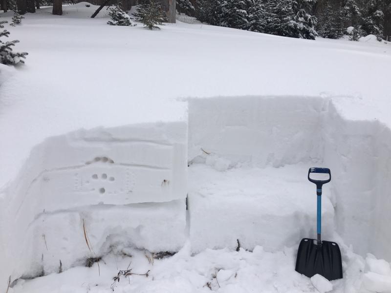
Photo of stability test illustrates how the most recent snow has formed a cohesive layer or slab that can slide off the older, weaker snow underneath. Additional snow will exacerbate the problem. |
| type | aspect/elevation | characteristics |
|---|

|
|
LIKELIHOOD
LIKELY
UNLIKELY
SIZE
LARGE
SMALL
TREND
INCREASING DANGER
SAME
DECREASING DANGER
|
|
description
Increasing winds and snow on the way translate to developing wind slabs in upper elevation, wind exposed terrain. Be on the lookout for smooth, rounded deposits of wind drifted snow that form on the lee sides of ridge crests and terrain features. A triggered wind slab has the potential to step down triggering a deeper and more dangerous, persistent slab avalanche. |
 |
weather It's going to be frigid today as winds shift direction and the storm moves out of the area. High temps at 10,000' will be in the single digits with wind chill values well below zero. We'll see a little break with some partially clearing skies into tomorrow before the next system moves into the area.
|
| general announcements The UAC has new support programs with Outdoor Research and Darn Tough. Support the UAC through your daily shopping. When you shop at Smith's, or online at Outdoor Research, REI, Backcountry.com, Darn Tough, Patagonia, NRS, Amazon, eBay a portion of your purchase will be donated to the FUAC. See our Donate Page for more details on how you can support the UAC when you shop. Benefit the Utah Avalanche Center when you buy or sell on eBay - set the Utah Avalanche Center as a favorite non-profit in your eBay account here and click on eBay gives when you buy or sell. You can choose to have your seller fees donated to the UAC, which doesn't cost you a penny This information does not apply to developed ski areas or highways where avalanche control is normally done. This advisory is from the U.S.D.A. Forest Service, which is solely responsible for its content. This advisory describes general avalanche conditions and local variations always occur. |