25th Annual Black Diamond Fall Fundraising Party
Thursday, September 13; 6:00-10:00 PM; Black Diamond Parking Lot
25th Annual Black Diamond Fall Fundraising Party
Thursday, September 13; 6:00-10:00 PM; Black Diamond Parking Lot
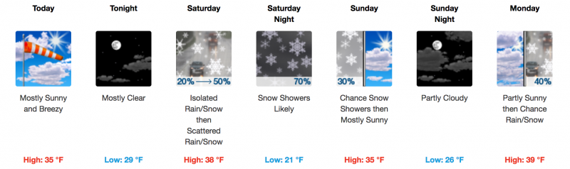
| Advisory: Abajo Area Mountains | Issued by Eric Trenbeath for Friday - March 24, 2017 - 7:29am |
|---|

|
bottom line With only a couple inches of new snow falling since yesterday, the avalanche danger is generally LOW in the Abajo Mountains. There may be a few shallow, unstable, isolated wind drifts on leeward slopes at upper elevations, and with daytime heating, we may see some loose, wet avalanche activity on sun exposed slopes.
|
 |
special announcement The Abajo/Blue Mountain avalanche advisory will provide detailed information on the weekends. During the week, general information and a danger rating will be posted. |
 |
weather Today we'll see clearing skies and a brief period of ridging before the next storm system affects our area on Saturday. High temperatures at 10,000' will be in the low 30's and northwest winds will continue to blow in the 20-30 mph range along ridge tops. |
| general announcements If you are getting out into the mountains, we love to hear from you! You can SUBMIT OBSERVATIONS ONLINE If you would like to have avalanche advisories emailed to you, SIGN UP HERE Benefit the Utah Avalanche Center when you shop from Backcountry.com or REI: Click this link for Backcountry.com or this link to REI, shop, and they will donate a percent of your purchase price to the UAC. Both offer free shipping (with some conditions) so this costs you nothing! Benefit the Utah Avalanche Center when you buy or sell on ebayIf you sign up for AmazonSmile and designate the Utah Avalanche Center as your favorite charity, they will donate a portion of everything you spend to the UAC. I doesn't cost you a penny and we'd really appreciate the help. The information in this advisory is from the US Forest Service which is solely responsible for its content. This advisory describes general avalanche conditions and local variations always occur. |