25th Annual Black Diamond Fall Fundraising Party
Thursday, September 13; 6:00-10:00 PM; Black Diamond Parking Lot
25th Annual Black Diamond Fall Fundraising Party
Thursday, September 13; 6:00-10:00 PM; Black Diamond Parking Lot
| Advisory: Abajo Area Mountains | Issued by Eric Trenbeath for Sunday - March 5, 2017 - 7:09am |
|---|

|
bottom line The avalanche danger is MODERATE today and backcountry travelers will need to be alert to newly formed wind slabs in upper elevation, wind exposed terrain. There also remains an isolated, or MODERATE danger for triggering an avalanche on a buried weak layer on steep slopes right around tree line and above that face NW-N-NE. Most other terrain offers LOW danger.
|
 |
special announcement The Abajo/Blue Mountain avalanche advisory will provide detailed information on the weekends. During the week, general information and a danger rating will be posted. |
 |
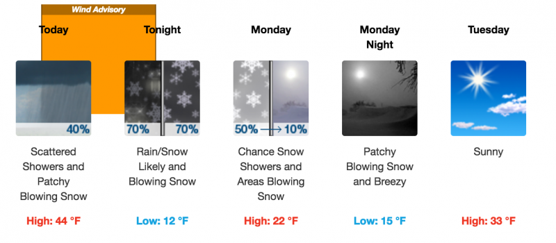
current conditions The story is the wind. Southeasterly winds have been blowing in the 30-40 mph range for the past 24 hours along ridge tops. Today they will shift to the SW with gusts to 60 mph. It's a warm 33 degrees at Camp Jackson and 19 up on Abajo Peak. Snow surfaces range from sun crusted to wind scoured with a few areas of settled powder left in sheltered areas. . |
| type | aspect/elevation | characteristics |
|---|

|
|
LIKELIHOOD
 LIKELY
UNLIKELY
SIZE
 LARGE
SMALL
TREND
 INCREASING DANGER
SAME
DECREASING DANGER
|
|
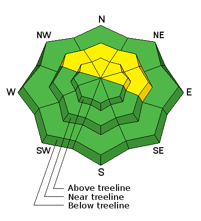
description
Small wind slabs will be your primary concern today, especially in the high country. Though there isn't a lot of loose snow available for transport, winds of this intensity will scour into the snow surface on windward slopes, picking up snow and transporting it to leeward slopes. Slabs today won't be well connected, but rather more of an isolated nature, sometimes appearing as ribbons along the leeward sides of gully walls and other terrain features. Avoid steep slopes with recent deposits of wind drifted snow, especially if they have a hollow feel or sound to them. |
| type | aspect/elevation | characteristics |
|---|

|
|
LIKELIHOOD
 LIKELY
UNLIKELY
SIZE
 LARGE
SMALL
TREND
INCREASING DANGER
SAME
DECREASING DANGER
|
|
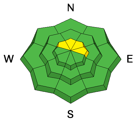
description
Areas with weak, underlying snow exist, and on Friday Brian Murdock and I experienced collapsing and whumphing along upper elevation ridge crests. Whumphing was also reported earlier in the week when the new snow came in. Though not widespread, this phenomenon tells me that the underlying snowpack is still trying to adjust to the most recent snow load, and that there are a few areas out there where you could trigger an avalanche. Most likely areas are on steep slopes right around tree line and above that face the north half of the compass. |
 |
weather Southwest winds will be on the increase today ahead of a storm system that will begin to affect the area this evening. Gusts may exceed 60 mph. High temperatures at 10,000' will be in the upper 30's. Most of the energy is passing to the north but we could see few inches of snow by Monday.
|
| general announcements If you are getting out into the mountains, we love to hear from you! You can SUBMIT OBSERVATIONS ONLINE If you would like to have avalanche advisories emailed to you, SIGN UP HERE Benefit the Utah Avalanche Center when you shop from Backcountry.com or REI: Click this link for Backcountry.com or this link to REI, shop, and they will donate a percent of your purchase price to the UAC. Both offer free shipping (with some conditions) so this costs you nothing! Benefit the Utah Avalanche Center when you buy or sell on ebayIf you sign up for AmazonSmile and designate the Utah Avalanche Center as your favorite charity, they will donate a portion of everything you spend to the UAC. I doesn't cost you a penny and we'd really appreciate the help. The information in this advisory is from the US Forest Service which is solely responsible for its content. This advisory describes general avalanche conditions and local variations always occur. |