25th Annual Black Diamond Fall Fundraising Party
Thursday, September 13; 6:00-10:00 PM; Black Diamond Parking Lot
25th Annual Black Diamond Fall Fundraising Party
Thursday, September 13; 6:00-10:00 PM; Black Diamond Parking Lot
| Advisory: Abajo Area Mountains | Issued by Eric Trenbeath for Saturday - March 4, 2017 - 6:45am |
|---|


|
bottom line The avalanche danger is MODERATE and human triggered avalanches are possible on steep slopes today. Lingering wind slabs, and snow on top of buried weak layers present isolated problems on steep, northerly facing aspects. With daytime heating, may we see some loose, wet slide activity on sun exposed slopes. Look for signs of instability such as pinwheels, roller balls, and sloppy wet snow. Stay off of and out form under steep slopes when these signs are present.
|
 |
special announcement The Abajo/Blue Mountain avalanche advisory will provide detailed information on the weekends. During the week, general information and a danger rating will be posted. |
 |
current conditions
High clouds have begun to stream into the area, and southwest winds have been on the increase overnight averaging 15-20 mph along ridge tips. Expect them to continue to increase throughout the day. Overnight lows dipped below freezing at Camp Jackson, and it's currently 19 degrees on Abajo Peak. 8" of snow fell earlier in the week but a strong sun over the past couple of days has formed a crust on sunny aspects. Wind exposed slopes have taken a hit as well, you'll need to seek shelter for soft snow. |
| type | aspect/elevation | characteristics |
|---|

|

|
LIKELIHOOD
 LIKELY
UNLIKELY
SIZE
 LARGE
SMALL
TREND
 INCREASING DANGER
SAME
DECREASING DANGER
|
|
description
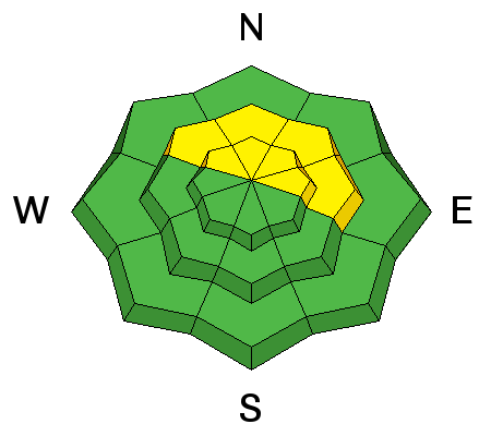
There are a few isolated wind slabs lurking about in upper elevation, wind exposed terrain, primarily on slopes that face NW-NE-SE. These slabs are mostly stiff, and will be stubborn to release, but continue to suspect smooth rounded pillows of wind drifted snow. Look for them on the lee sides of ridge crests and terrain features such as gully walls and sub-ridges. |
| type | aspect/elevation | characteristics |
|---|

|
|
LIKELIHOOD
LIKELY
UNLIKELY
SIZE
LARGE
SMALL
TREND
INCREASING DANGER
SAME
DECREASING DANGER
|
|
description
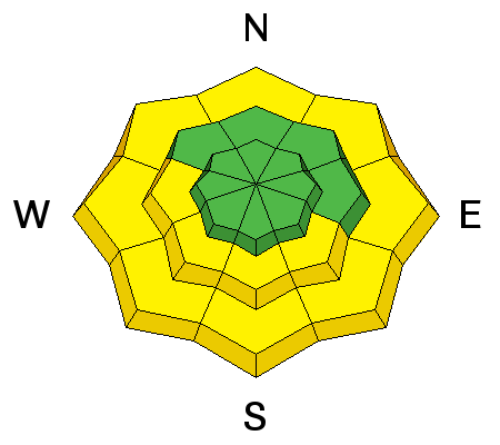
Areas with weak, underlying snow exist, and yesterday Brian Murdock and I experienced collapsing and whumphing along upper elevation ridge crests. Whumphing was also reported earlier in the week when the new snow came in. Though not widespread, this phenomenon tells me that the underlying snowpack is still trying to adjust to the most recent snow load, and that there are a few areas out there where you could trigger an avalanche. Most likely areas are on steep slopes right around tree line and above that face the north half of the compass. |
| type | aspect/elevation | characteristics |
|---|

|
|
LIKELIHOOD
 LIKELY
UNLIKELY
SIZE
 LARGE
SMALL
TREND
 INCREASING DANGER
SAME
DECREASING DANGER
|
|
description
Today will be the warmest day of the week, and we could see some loose, wet slide activity on sun exposed slopes as the day heats up. Look for signs of instability such as roller balls or pinwheels, and stay off of steep slopes if the snow is wet and sloppy. |
 |
weather Winds will be on the increase today ahead of a storm system that will begin to affect the area on Sunday. Most of the energy is passing to the north but we could see few inches of snow buy Monday. |
| general announcements If you are getting out into the mountains, we love to hear from you! You can SUBMIT OBSERVATIONS ONLINE If you would like to have avalanche advisories emailed to you, SIGN UP HERE Benefit the Utah Avalanche Center when you shop from Backcountry.com or REI: Click this link for Backcountry.com or this link to REI, shop, and they will donate a percent of your purchase price to the UAC. Both offer free shipping (with some conditions) so this costs you nothing! Benefit the Utah Avalanche Center when you buy or sell on ebayIf you sign up for AmazonSmile and designate the Utah Avalanche Center as your favorite charity, they will donate a portion of everything you spend to the UAC. I doesn't cost you a penny and we'd really appreciate the help. The information in this advisory is from the US Forest Service which is solely responsible for its content. This advisory describes general avalanche conditions and local variations always occur. |