25th Annual Black Diamond Fall Fundraising Party
Thursday, September 13; 6:00-10:00 PM; Black Diamond Parking Lot
25th Annual Black Diamond Fall Fundraising Party
Thursday, September 13; 6:00-10:00 PM; Black Diamond Parking Lot
| Advisory: Abajo Area Mountains | Issued by Eric Trenbeath for Saturday - February 11, 2017 - 7:09am |
|---|


|
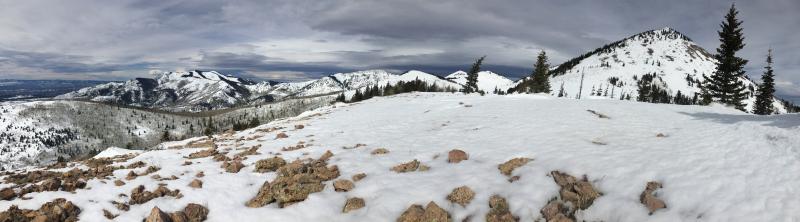
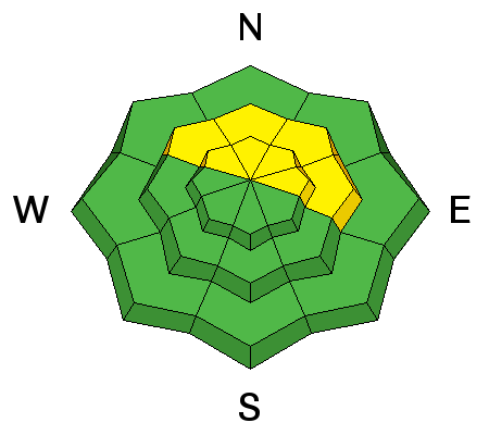
bottom line Today look for an increasing MODERATE danger for newly deposited wind slabs, primarily in upper elevation, wind exposed terrain that faces NW-N-E. Snow totals today will directly influence the degree of danger, and backcountry travelers will need to be alert to changing conditions. Avoid newly deposited wind drifts in steep terrain, and look for signs of instability such as cracking in the snow surface. There is also a MODERATE danger for loose, wet slide activity, primarily at lower elevations. Avoid steep slopes with a wet, or punchy, unsupportable surface.
|
 |
special announcement The Abajo/Blue Mountain avalanche advisory will provide detailed information on the weekends. During the week, general information and a danger rating will be posted. |
 |
current conditions Temperatures have finally cooled to just above freezing at 10,000', and southwest winds are blowing in the 25-30 mph range along ridge tops. Extremely warm temperatures over the past few days have turned the snowpack at mid and lower elevations into the consistency of a snow cone, and strong winds from the southwest have hammered the upper elevations. A refresh is in sight, but I can't say I would rush right out there this morning. Timing, and snow fall amounts from this warm and complicated system are uncertain. I spoke with NWS forecasters this morning and their confidence in the current forecast was low, but we may see 4" of new snow by days end.
In my travels up and around the south end of South Peak yesterday I found mostly damp, wind and sun affected snow. Overall coverage in the range however is looking pretty good but for the most sun and wind exposed ridge lines. |
| type | aspect/elevation | characteristics |
|---|

|
|
LIKELIHOOD
 LIKELY
UNLIKELY
SIZE
 LARGE
SMALL
TREND
 INCREASING DANGER
SAME
DECREASING DANGER
|
|
description
An increase in avalanche danger will directly correlate to snow fall amounts today. As new snow accumulates, be alert to fresh wind drifts and developing wind slabs on the leeward sides of ridge crests and terrain features in upper elevation, wind exposed terrain. New wind slabs will be mostly shallow and should fit into the "manageable" category, but give them a little test before committing to steep terrain. |
| type | aspect/elevation | characteristics |
|---|

|
|
LIKELIHOOD
LIKELY
UNLIKELY
SIZE
LARGE
SMALL
TREND
 INCREASING DANGER
SAME
DECREASING DANGER
|
|
description
Cooler temperatures and clouds will help put a stop to loose, wet snow instabilities, but it's been a few days since we had a solid refreeze at mid and lower elevations. If you find yourself on a punchy, unsupportable surface with Slurpee like snow underneath, find another place to be if the slope you are on is steeper than about 35 degrees. |
 |
weather A warm, moist storm system will move through our area today and tonight, though timing and snowfall amounts are uncertain. Best estimate is for 3-5" today with snow continuing through tomorrow. Southwest winds will average 15-20 mph with gusts in the 30's, and daytime high temperatures will be right around freezing at 10,000'. |
| general announcements If you are getting out into the mountains, we love to hear from you! You can SUBMIT OBSERVATIONS ONLINE If you would like to have avalanche advisories emailed to you, SIGN UP HERE Benefit the Utah Avalanche Center when you shop from Backcountry.com or REI: Click this link for Backcountry.com or this link to REI, shop, and they will donate a percent of your purchase price to the UAC. Both offer free shipping (with some conditions) so this costs you nothing! Benefit the Utah Avalanche Center when you buy or sell on ebayIf you sign up for AmazonSmile and designate the Utah Avalanche Center as your favorite charity, they will donate a portion of everything you spend to the UAC. I doesn't cost you a penny and we'd really appreciate the help. The information in this advisory is from the US Forest Service which is solely responsible for its content. This advisory describes general avalanche conditions and local variations always occur. |