25th Annual Black Diamond Fall Fundraising Party
Thursday, September 13; 6:00-10:00 PM; Black Diamond Parking Lot
25th Annual Black Diamond Fall Fundraising Party
Thursday, September 13; 6:00-10:00 PM; Black Diamond Parking Lot
| Advisory: Abajo Area Mountains | Issued by Eric Trenbeath for Sunday - February 5, 2017 - 7:23am |
|---|

|
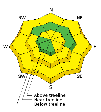
bottom line An isolated or MODERATE danger exists on steep slopes facing N-E-SE right around tree line and above where you may still be able to trigger an old hard wind slab or deeper persistent slab avalanche. With daytime heating, sun exposed slopes and low elevation, northerly aspects will become wet and sloppy, and there will be a MODERATE danger for loose, wet avalanches.
|
 |
special announcement The Abajo/Blue Mountain avalanche advisory will provide detailed information on the weekends. During the week, general information and a danger rating will be posted. |
 |
current conditions The January thaw is here and the snow surface is getting a bit tired and worn from the wind and sun. Seek out sheltered locations for the best snow conditions. Sun exposed slopes are getting cooked each day, and slopes with breakable crusts will become more widespread as the week progresses. Overall snow depth now ranges from 2-4' across the range. Wind speed, temperature, and humidity on Abajo Peak. New snow totals at Camp Jackson. |
| type | aspect/elevation | characteristics |
|---|

|
|
LIKELIHOOD
 LIKELY
UNLIKELY
SIZE
 LARGE
SMALL
TREND
 INCREASING DANGER
SAME
DECREASING DANGER
|
|
description
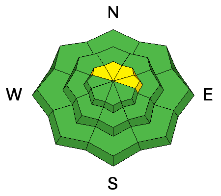
You may still find a few wind slabs lurking about in upper elevation, wind exposed terrain. Look for smooth, rounded pillows of wind deposited snow on the lee sides of ridge crests and terrain features such as gully walls, sub-ridges and rock buttresses, and avoid them in areas of steep terrain. |
| type | aspect/elevation | characteristics |
|---|

|
|
LIKELIHOOD
LIKELY
UNLIKELY
SIZE
 LARGE
SMALL
TREND
INCREASING DANGER
SAME
DECREASING DANGER
|
|
description
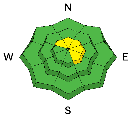
We are trending toward mostly stable conditions but isolated slopes still display weak layers of faceted snow. Steep, extreme terrain that faces north still harbors weak faceted snow around the rocks. If you start to push into bigger terrain, take the time to dig down about three feet to evaluate the snow stability. It still may be possible to trigger a deep and dangerous avalanche in these areas. |
| type | aspect/elevation | characteristics |
|---|

|
|
LIKELIHOOD
LIKELY
UNLIKELY
SIZE
LARGE
SMALL
TREND
 INCREASING DANGER
SAME
DECREASING DANGER
|
|
description
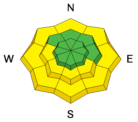
With daytime heating, sun exposed slopes and low elevation, northerly aspects will become wet and sloppy, and there will be an increasing danger for loose, wet avalanches. |
 |
weather Today Mostly sunny, with a high near 37. Southwest wind 10 to 15 mph. Tonight A 40 percent chance of snow, mainly after 2am. Mostly cloudy, with a low around 24. Breezy, with a south wind 15 to 20 mph, with gusts as high as 35 mph. Monday Snow likely, mainly before 11am. Mostly cloudy, with a high near 27. Breezy, with a west southwest wind around 25 mph, with gusts as high as 40 mph. Chance of precipitation is 60%. New snow accumulation of less than a half inch possible. Monday Night Snow likely, mainly after 11pm. Mostly cloudy, with a low around 27. Windy, with a west southwest wind 25 to 30 mph, with gusts as high as 45 mph. Chance of precipitation is 70%. New snow accumulation of around an inch possible. Tuesday Snow likely. Mostly cloudy, with a high near 31. Breezy, with a west wind 20 to 25 mph, with gusts as high as 40 mph. Chance of precipitation is 60%. |
| general announcements If you are getting out into the mountains, we love to hear from you! You can SUBMIT OBSERVATIONS ONLINE If you would like to have avalanche advisories emailed to you, SIGN UP HERE Benefit the Utah Avalanche Center when you shop from Backcountry.com or REI: Click this link for Backcountry.com or this link to REI, shop, and they will donate a percent of your purchase price to the UAC. Both offer free shipping (with some conditions) so this costs you nothing! Benefit the Utah Avalanche Center when you buy or sell on ebayIf you sign up for AmazonSmile and designate the Utah Avalanche Center as your favorite charity, they will donate a portion of everything you spend to the UAC. I doesn't cost you a penny and we'd really appreciate the help. The information in this advisory is from the US Forest Service which is solely responsible for its content. This advisory describes general avalanche conditions and local variations always occur. |


