25th Annual Black Diamond Fall Fundraising Party
Thursday, September 13; 6:00-10:00 PM; Black Diamond Parking Lot
25th Annual Black Diamond Fall Fundraising Party
Thursday, September 13; 6:00-10:00 PM; Black Diamond Parking Lot
| Advisory: Abajo Area Mountains | Issued by Eric Trenbeath for Tuesday - January 31, 2017 - 7:26am |
|---|

|
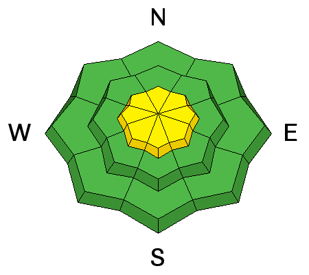
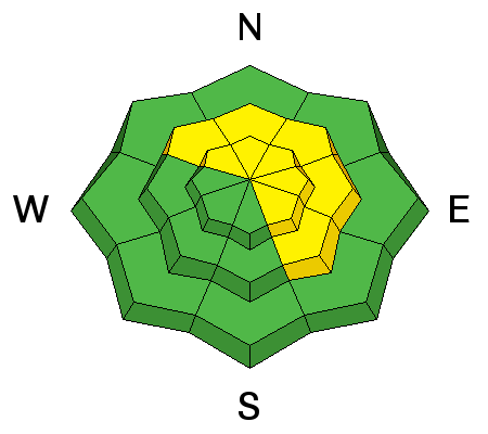
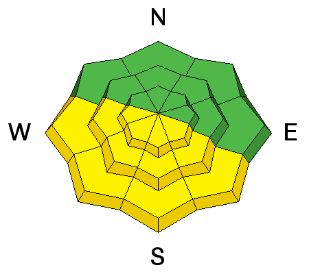
bottom line Today there is a MODERATE avalanche danger for triggering wind slabs old and new on all aspects in steep, upper elevation, wind exposed terrain. There is also an isolated MODERATE danger for triggering a deeper, persistent slab avalanche on slopes steeper than 35 degrees, at mid and upper elevations on slopes facing NW-E-SE. And finally, with daytime heating, a MODERATE danger exists for loose, wet slide activity on sun exposed slopes.
|
 |
special announcement The Abajo/Blue Mountain avalanche advisory will provide detailed information on the weekends. During the week, general information and a danger rating will be posted. Backcountry 101 Avalanche Class We will be offering a Backcountry 101 avalanche class on Feb 3, 4. This course will include a night classroom session and a day in the field. Cost is $125 with proceeds to benefit the Utah Avalanche Center Moab. For more information or to sign up go here. |
 |
current conditions The January thaw is here and the snow surface is getting a bit tired and worn from the wind and sun. Seek out sheltered locations for the best snow conditions. Sun exposed slopes are getting cooked each day, and slopes with breakable crusts will become more widespread as the week progresses. Overall snow depth now ranges from 2-4' across the range. |
| type | aspect/elevation | characteristics |
|---|

|
|
LIKELIHOOD
 LIKELY
UNLIKELY
SIZE
 LARGE
SMALL
TREND
 INCREASING DANGER
SAME
DECREASING DANGER
|
|
description
You may still find a few wind slabs lurking about in upper elevation, wind exposed terrain. Look for smooth, rounded pillows of wind deposited snow on the lee sides of ridge crests and terrain features such as gully walls, sub-ridges and rock buttresses, and avoid them in areas of steep terrain. |
| type | aspect/elevation | characteristics |
|---|

|
|
LIKELIHOOD
 LIKELY
UNLIKELY
SIZE
 LARGE
SMALL
TREND
INCREASING DANGER
SAME
DECREASING DANGER
|
|
description
Heavy snowfall and wind loading last weekend increased the stress on buried weak layers and several slides broke down into older snow. The snowpack has begun to adjust to this new load, but steep terrain should still be approached with caution. Upper-mid elevation, northerly facing aspects are the most suspect, particularly in areas of steep, rocky, heavily featured terrain. |
| type | aspect/elevation | characteristics |
|---|

|
|
LIKELIHOOD
LIKELY
UNLIKELY
SIZE
 LARGE
SMALL
TREND
 INCREASING DANGER
SAME
DECREASING DANGER
|
|
description
With daytime heating we may see some loose, wet slide activity on sun exposed slopes. I don't see these packing much of a punch, but it's good to be aware of signs of instability such as roller balls, and sloppy wet snow, and good practice to stay off of steep slopes when these signs are present. |
 |
weather High pressure is building over the region and temperatures should gradually warm over the next few days. The long range shows a hint at precipitation by late next week. |
| general announcements If you are getting out into the mountains, we love to hear from you! You can SUBMIT OBSERVATIONS ONLINE If you would like to have avalanche advisories emailed to you, SIGN UP HERE Benefit the Utah Avalanche Center when you shop from Backcountry.com or REI: Click this link for Backcountry.com or this link to REI, shop, and they will donate a percent of your purchase price to the UAC. Both offer free shipping (with some conditions) so this costs you nothing! Benefit the Utah Avalanche Center when you buy or sell on ebayIf you sign up for AmazonSmile and designate the Utah Avalanche Center as your favorite charity, they will donate a portion of everything you spend to the UAC. I doesn't cost you a penny and we'd really appreciate the help. The information in this advisory is from the US Forest Service which is solely responsible for its content. This advisory describes general avalanche conditions and local variations always occur. |


