25th Annual Black Diamond Fall Fundraising Party
Thursday, September 13; 6:00-10:00 PM; Black Diamond Parking Lot
25th Annual Black Diamond Fall Fundraising Party
Thursday, September 13; 6:00-10:00 PM; Black Diamond Parking Lot
| Advisory: Abajo Area Mountains | Issued by Eric Trenbeath for Sunday - January 22, 2017 - 7:28am |
|---|

|
bottom line The avalanche danger is CONSIDERABLE today and human triggered avalanches are likely on steep slopes on all aspects. Avalanches within the storm snow remain the primary concern, but a rising danger for fresh wind slabs will develop during the day. Look for signs of instability such as cracking in the snow surface and avoid slopes with recent deposits of wind drifted snow. Cautious route finding and conservative decision making are essential for safe, backcountry travel today.
|
 |
special announcement The Abajo/Blue Mountain avalanche advisory will provide detailed information on the weekends. During the week, general information and a danger rating will be posted. Backcountry 101 Avalanche Class We will be offering a Backcountry 101 avalanche class on Feb 3, 4. This course will include a night classroom session and a day in the field. Cost is $125 with proceeds to benefit the Utah Avalanche Center Moab. For more information or to sign up go here. |
 |
current conditions The Abajo/Blue mountains received 18" of new snow with more than 2" of water content from this storm cycle. Today expect to find deep snow and dangerous avalanche conditions. Northwesterly winds have been light to moderate overnight but will be on the increase shifting to southwesterly later today. 10,000' temperatures are in the single digits. |
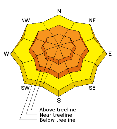
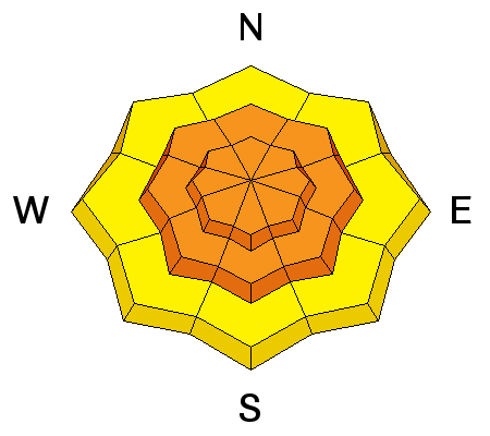
| type | aspect/elevation | characteristics |
|---|

|
|
LIKELIHOOD
 LIKELY
UNLIKELY
SIZE
 LARGE
SMALL
TREND
 INCREASING DANGER
SAME
DECREASING DANGER
|
|
description
Storm slabs will be less sensitive today, but they will still be reactive to human triggers on slopes steeper than 35 degrees on all aspects at mid and upper elevations. Up to 2' deep these slabs will be beyond the manageable range and you don't want to get caught in them. Choose your terrain wisely today and stick to lower angle slopes. |
| type | aspect/elevation | characteristics |
|---|

|
|
LIKELIHOOD
LIKELY
UNLIKELY
SIZE
LARGE
SMALL
TREND
INCREASING DANGER
SAME
DECREASING DANGER
|
|
description
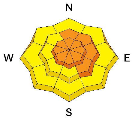
Southwesterly winds will be on the increase today and there is plenty of loose snow to blow around. Be on the lookout for developing wind slabs in upper elevation, wind exposed terrain and avoid steep slopes with recent deposits of wind drifted snow. The danger will be most pronounced on slopes facing NW-N-E, but with so much snow available for transport, any terrain feature will be able to capture some snow, and wind slab development will be possible on all aspects above tree line. |
| type | aspect/elevation | characteristics |
|---|

|

|
LIKELIHOOD
LIKELY
UNLIKELY
SIZE
 LARGE
SMALL
TREND
 INCREASING DANGER
SAME
DECREASING DANGER
|
|
description
The new load of snow will our fragile snowpack to the test, and today there will be the potential for triggering a deep, persistent slab avalanche on weak sugary snow at the ground. You are most likely to encounter this problem in steep, northerly facing aspects where the underlying snow is shallow and weak. |
 |
weather Today Snow showers likely, mainly after 3pm. Widespread blowing snow after 4pm. Cloudy, with a high near 24. Windy, with a south southwest wind 10 to 20 mph increasing to 20 to 30 mph in the afternoon. Winds could gust as high as 40 mph. Chance of precipitation is 70%. Total daytime snow accumulation of 1 to 2 inches possible. Tonight Snow showers. Widespread blowing snow. Low around 22. Very windy, with a south southwest wind 30 to 40 mph, with gusts as high as 55 mph. Chance of precipitation is 90%. New snow accumulation of 3 to 7 inches possible. Monday Snow showers. The snow could be heavy at times. Widespread blowing snow, mainly before 5pm. High near 27. Very windy, with a southwest wind 35 to 40 mph decreasing to 30 to 35 mph in the afternoon. Winds could gust as high as 55 mph. Chance of precipitation is 90%. New snow accumulation of 5 to 9 inches possible. |
| general announcements If you are getting out into the mountains, we love to hear from you! You can SUBMIT OBSERVATIONS ONLINE If you would like to have avalanche advisories emailed to you, SIGN UP HERE Benefit the Utah Avalanche Center when you shop from Backcountry.com or REI: Click this link for Backcountry.com or this link to REI, shop, and they will donate a percent of your purchase price to the UAC. Both offer free shipping (with some conditions) so this costs you nothing! Benefit the Utah Avalanche Center when you buy or sell on ebayIf you sign up for AmazonSmile and designate the Utah Avalanche Center as your favorite charity, they will donate a portion of everything you spend to the UAC. I doesn't cost you a penny and we'd really appreciate the help. The information in this advisory is from the US Forest Service which is solely responsible for its content. This advisory describes general avalanche conditions and local variations always occur. |


