25th Annual Black Diamond Fall Fundraising Party
Thursday, September 13; 6:00-10:00 PM; Black Diamond Parking Lot
25th Annual Black Diamond Fall Fundraising Party
Thursday, September 13; 6:00-10:00 PM; Black Diamond Parking Lot
| Advisory: Abajo Area Mountains | Issued by Eric Trenbeath for Saturday - January 21, 2017 - 7:16am |
|---|

|
bottom line The avalanche danger is HIGH today in steep, upper elevation, wind exposed terrain that faces NW-NE-E, and natural and human triggered avalanches are likely in these areas. A CONSIDERABLE danger exists on all aspects at mid, and upper elevations on slopes approaching 35 degrees. Backcountry travelers need to have excellent route finding skills and avoid avalanche terrain by staying off of and out from under steep slopes.
|
 |
special announcement The Abajo/Blue Mountain avalanche advisory will provide detailed information on the weekends. During the week, general information and a danger rating will be posted. |
 |
current conditions 18" of new snow has fallen at Camp Jackson at 9000' since Thursday night and I'd expect to find up to 2' at upper elevatons. Southerly winds have been blowing in the 20 -30 mph range with gusts as high as 40. They'll decrease a bit and shift to the northwest later today. Yesterday I observed lots of snow blowing around, and with the additional 13" overnight, the avalanche danger has significantly increased. |
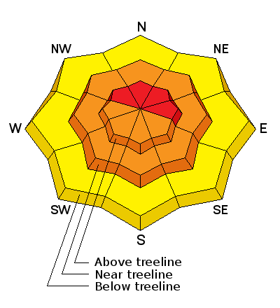
| type | aspect/elevation | characteristics |
|---|

|

|
LIKELIHOOD
 LIKELY
UNLIKELY
SIZE
 LARGE
SMALL
TREND
 INCREASING DANGER
SAME
DECREASING DANGER
|
|
description
Dangerous wind slabs exist right around tree line and above where moderate to strong winds have had copious amounts of fresh snow to blow around. The danger will be highest on slopes facing the north half of the compass, but as winds shift today expect to find newly formed wind slabs on all aspects at upper elevations. Suspect any smooth rounded deposit of wind drifted snow. |
| type | aspect/elevation | characteristics |
|---|

|
|
LIKELIHOOD
LIKELY
UNLIKELY
SIZE
LARGE
SMALL
TREND
INCREASING DANGER
SAME
DECREASING DANGER
|
|
description
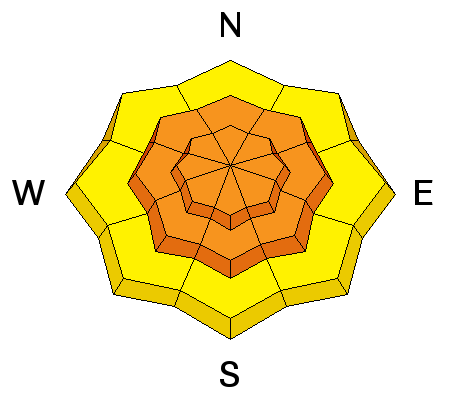
Avalanches within the new snow will be likely today on all aspects on slopes approaching 35 degrees or steeper. They may present themselves as loose snow sluffs or as cohesive soft slabs. Long and fast running, they could pack a considerable punch if they entrain enough snow. Stay off of and out from under steep terrain, particularly in alpine areas where starting zones extend well into the wind zone. |
| type | aspect/elevation | characteristics |
|---|

|
|
LIKELIHOOD
LIKELY
UNLIKELY
SIZE
 LARGE
SMALL
TREND
 INCREASING DANGER
SAME
DECREASING DANGER
|
|
description
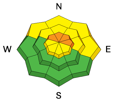
The new load of snow will our fragile snowpack to the test, and today there will be the potential for triggering a deep, persistent slab avalanche on weak sugary snow at the ground. You are most likely to encounter this problem in steep, northerly facing aspects where the underlying snow is shallow and weak. |
 |
weather Today Snow showers. The snow could be heavy at times. High near 26. Windy, with a southwest wind 15 to 20 mph becoming northwest 25 to 30 mph in the afternoon. Winds could gust as high as 45 mph. Chance of precipitation is 100%. Total daytime snow accumulation of 3 to 7 inches possible. Tonight A chance of snow showers before 11pm, then a chance of snow showers after 3am. Partly cloudy, with a low around 15. Windy, with a northwest wind 25 to 30 mph decreasing to 15 to 20 mph after midnight. Winds could gust as high as 45 mph. Chance of precipitation is 40%. Sunday Snow showers likely, mainly after 11am. Cloudy, with a high near 24. Breezy, with a southwest wind 15 to 20 mph increasing to 20 to 25 mph in the afternoon. Chance of precipitation is 60%. New snow accumulation of 1 to 3 inches possible. Sunday Night Snow showers. Low around 22. Windy, with a south southwest wind 25 to 30 mph. Chance of precipitation is 80%. New snow accumulation of 3 to 7 inches possible. Monday Snow showers. The snow could be heavy at times. High near 28. Windy, with a southwest wind 30 to 35 mph, with gusts as high as 45 mph. Chance of precipitation is 90%. |


