| Please join us at the 23rd annual Black Diamond Fall Fundraiser Party Thursday Sept 15. Tickets are on sale now here, at the Black Diamond store & at REI. Special bonus raffle for online ticket purchasers! |
| Please join us at the 23rd annual Black Diamond Fall Fundraiser Party Thursday Sept 15. Tickets are on sale now here, at the Black Diamond store & at REI. Special bonus raffle for online ticket purchasers! |
| Advisory: Abajo Area Mountains | Issued by Eric Trenbeath for Sunday - April 3, 2016 - 7:25am |
|---|

|
bottom line The avalanche danger is generally LOW this morning but will rise to MODERATE as daytime heating increases the potential for wet slide activity on steep, sun exposed slopes. Watch for signs of instability such as roller balls, pinwheels, and wet, sloppy snow, and get off of, and out from under steep slopes when these signs are present. Remember that low danger doesn't mean no danger and unstable snow may exist on isolated terrain features, particularly in areas of more extreme radical terrain where it still may be possible to trigger and errant wind slab, or have a cornice break off beneath you. Continue to practice safe travel techniques and carry appropriate rescue gear.
|
 |
special announcement The Abajo / Blue Mountain advisory provides detailed snow, mountain weather, and avalanche information on weekends. During the week, an overall danger rating will be provided with current condition information available through the weather links below.
|
 |
current conditions
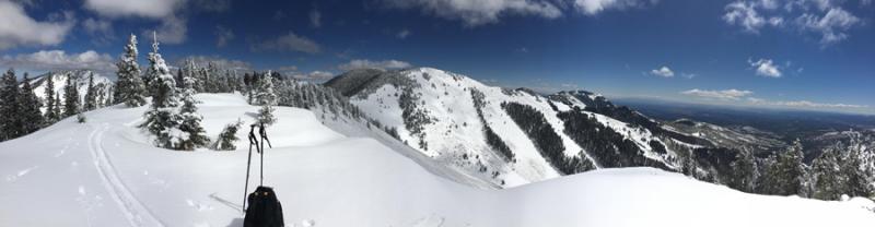
Skies are clear, northerly ridge top winds are blowing in the 10-15 mph range, and temps are in the low 20's at 10,000'. Spring conditions are in effect, but good settled powder can still be found on northerly aspects. Winds, temperature and humidity on Abajo Peak. Snow totals at Buckboard Flat. Snow totals at Camp Jackson.
|
 |
recent activity
|
| type | aspect/elevation | characteristics |
|---|

|
|
LIKELIHOOD
 LIKELY
UNLIKELY
SIZE
 LARGE
SMALL
TREND
 INCREASING DANGER
SAME
DECREASING DANGER
|
|
description
It appears as though the slow heating and crusting over of the snow surface after Tuesday's storm helped us avoid the effects of sun on new snow, and I've only observed very minor wet slide activity over the past few days. Nevertheless, with sunny skies and temperatures in the mid 40's at 10,000', you will need to be aware of the potential for wet slide activity on sun exposed slopes. Watch for the usual signs of instability such as roller balls, pinwheels, and off course, snow actually sluffing. And if you find yourself wallowing around in sloppy wet snow, it's time to get off of and out from under steep, sun exposed slopes. |
| type | aspect/elevation | characteristics |
|---|

|

|
LIKELIHOOD
 LIKELY
UNLIKELY
SIZE
 LARGE
SMALL
TREND
 INCREASING DANGER
SAME
DECREASING DANGER
|
|
description
Beyond the potential for wet slide activity in the afternoons, the snowpack is generally stable and the avalanche danger is mostly low. Low danger doesn't mean no danger, and areas of unstable snow may exist on isolated terrain features. As people push higher into more extreme terrain there still remains the possibility of triggering an errant wind slab. Cornices are also growing quite large and it's important to give them a wide berth. Continue to practice safe travel techniques by skiing or riding on slopes one at a time, and always carry a beacon, probe, and shovel. |
 |
weather High pressure will dominate the region through Monday. A weak disturbance to the north will bring some clouds and a slight chance of snow to the area on Tuesday. High pressure rebuilds for the remainder of the week with a stronger looking system out there on the horizon for next next weekend. Today Sunny, with a high near 43. Northwest wind around 10 mph. Tonight Mostly clear, with a low around 33. Northwest wind around 10 mph. Monday Mostly sunny, with a high near 47. South southwest wind 10 to 15 mph. Monday Night Partly cloudy, with a low around 32. Southwest wind around 15 mph becoming west northwest after midnight. Winds could gust as high as 25 mph. Tuesday Mostly sunny, with a high near 40. Breezy, with a northwest wind 15 to 20 mph. Tuesday Night Mostly clear, with a low around 26. Blustery. Wednesday Sunny, with a high near 42. |
| general announcements Let me know what you are seeing down there by posting an observation here. You can also call me on my cell phone at 801-647-8896 To receive this advisory by email go here. This information does not apply to developed ski areas or highways where avalanche control is normally done. This advisory is from the U.S.D.A. Forest Service, which is solely responsible for its content. This advisory describes general avalanche conditions and local variations always exist. |