| Please join us at the 23rd annual Black Diamond Fall Fundraiser Party Thursday Sept 15. Tickets are on sale now here, at the Black Diamond store & at REI. Special bonus raffle for online ticket purchasers! |
| Please join us at the 23rd annual Black Diamond Fall Fundraiser Party Thursday Sept 15. Tickets are on sale now here, at the Black Diamond store & at REI. Special bonus raffle for online ticket purchasers! |
| Advisory: Abajo Area Mountains | Issued by Eric Trenbeath for Saturday - April 2, 2016 - 6:38am |
|---|

|
bottom line Today the avalanche danger remains MODERATE in areas where you can detect deposits of wind drifted snow. The danger is most pronounced on upper elevation slopes that have a N-NE-E aspect. Suspect slopes with steep convexities, and areas of more extreme, rocky and radical terrain. And as the strong warm sun hits the new snow today, the danger for wet slide activity will rise to MODERATE on steep, sun exposed slopes. Look for signs of instability such as roller balls and pinwheels, and stay off of and out from under steep slopes when these signs are present.
|
 |
special announcement The Abajo / Blue Mountain advisory provides detailed snow, mountain weather, and avalanche information on weekends. During the week, an overall danger rating will be provided with current condition information available through the weather links below.
|
 |
current conditions
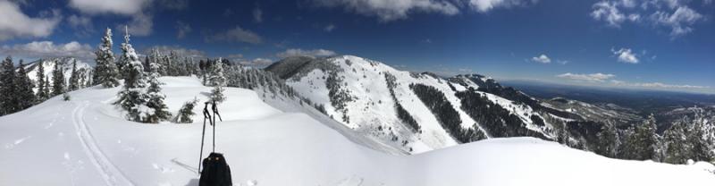
The Abajo Mountains picked up between 5-8" of new snow from Tuesday's storm, and conditions are greatly improved. In my travels yesterday up around Cooley Pass, and Jackson Ridge, I found abundant powder snow, even on some sun exposed slopes as cloud cover and cold temps most of the week kept heating under wraps. The sun was strong yesterday however, and expect to find many of these slopes to be crusted over today. Prior to the storm, many south facing slopes had melted out to the ground. These slopes are now covered with a few inches of new. Overall snow cover ranges from about 30" near Buckboard Flat to around 48" at upper elevations. Winds, temperature and humidity on Abajo Peak. Snow totals at Buckboard Flat. Snow totals at Camp Jackson.
|
 |
recent activity
|
| type | aspect/elevation | characteristics |
|---|

|
|
LIKELIHOOD
 LIKELY
UNLIKELY
SIZE
 LARGE
SMALL
TREND
 INCREASING DANGER
SAME
DECREASING DANGER
|
|
description
The sun and clouds have been playing cat and mouse over the last several days keeping wet slide activity down to a minimum. Today will be a different story however, with sunny skies and temperatures rising into the mid 40's around 10,000'. Be alert to signs of rising instability such as roller balls, pinwheels, and sloppy wet snow. Stay off of, and out from under steep, sun exposed slopes when these signs are present. Though the danger will be most pronounced on slopes that face E-S-W, northerly facing aspects aren't immune this time of year, particularly at lower elevations. |
| type | aspect/elevation | characteristics |
|---|

|

|
LIKELIHOOD
 LIKELY
UNLIKELY
SIZE
 LARGE
SMALL
TREND
 INCREASING DANGER
SAME
DECREASING DANGER
|
|
description
Though I suspect they have gained strength and are now fairly well bonded, you still need to be on the lookout for wind slabs that formed earlier in the week in upper elevation, wind exposed terrain. Carefully evaluate steep slopes for smooth rounded pillows of wind deposited snow. Be suspicious of convex break-overs and other terrain features in areas of steeper, more radical terrain. There may also be isolated cases where a triggered wind slab could fail on deeper, faceted snow in perhaps a repeat running slide path, or where the underlying snow pack is shallow and weak. |
 |
weather Today Sunny, with a high near 37. North northeast wind 5 to 10 mph becoming south southwest in the afternoon. Tonight Mostly clear, with a low around 30. West wind around 10 mph. Sunday Sunny, with a high near 43. Northwest wind 5 to 10 mph. Sunday Night Mostly clear, with a low around 33. North northwest wind around 10 mph. Monday Sunny, with a high near 46. South southwest wind 10 to 15 mph. |
| general announcements Let me know what you are seeing down there by posting an observation here. You can also call me on my cell phone at 801-647-8896 To receive this advisory by email go here. This information does not apply to developed ski areas or highways where avalanche control is normally done. This advisory is from the U.S.D.A. Forest Service, which is solely responsible for its content. This advisory describes general avalanche conditions and local variations always exist. |