| Please join us at the 23rd annual Black Diamond Fall Fundraiser Party Thursday Sept 15. Tickets are on sale now here, at the Black Diamond store & at REI. Special bonus raffle for online ticket purchasers! |
| Please join us at the 23rd annual Black Diamond Fall Fundraiser Party Thursday Sept 15. Tickets are on sale now here, at the Black Diamond store & at REI. Special bonus raffle for online ticket purchasers! |
| Advisory: Abajo Area Mountains | Issued by Eric Trenbeath for Saturday - February 27, 2016 - 7:02am |
|---|


|
bottom line The avalanche danger is generally LOW but remember that low danger doesn't mean no danger. Continue to exercise caution in areas of steep, rocky, more radical terrain where you may still be able to trigger an isolated wind slab, or even a deeper, buried persistent slab. As the day heats up, be alert to signs of wet instability on sun exposed slopes such as roller balls, pinwheels, or sloppy wet snow. Stay off of and out from under steep slopes when these signs are present.
|
 |
special announcement
|
 |
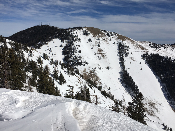
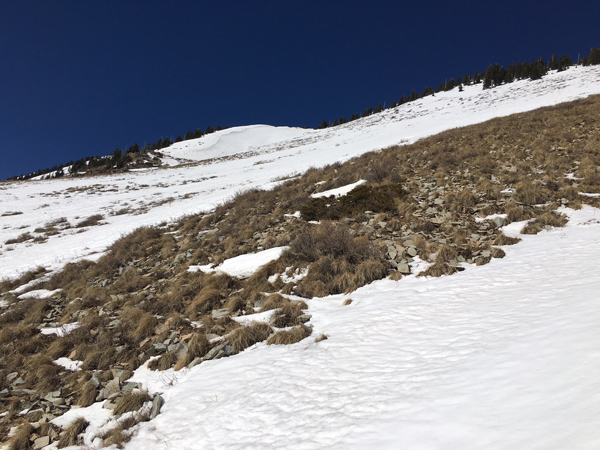
current conditions The 5" of new snow that fell on Monday night has settled out to about 3" on sheltered, northerly aspects, and has crusted over nearly everywhere else. Supportable corn snow is developing on sheltered, mid elevation southerly aspects, but the dry February has been tough on the snowpack in these areas, and many slopes are beginning to show rocks and dry ground. West southwest winds have been on the increase overnight and are currently blowing in the 20-30 mph range. It is 28 degrees on Abajo Peak and a balmy 35 at Buckboard Flat this morning.
Winds, temperature and humidity on Abajo Peak. Snow totals at Buckboard Flat. Snow totals at Camp Jackson.
|
 |
recent activity
|
| type | aspect/elevation | characteristics |
|---|

|
|
LIKELIHOOD
 LIKELY
UNLIKELY
SIZE
 LARGE
SMALL
TREND
 INCREASING DANGER
SAME
DECREASING DANGER
|
|
description
The avalanche danger is generally low right now, but low danger doesn't mean no danger and you should always maintain avalanche awareness and practice safe travel techniques in avalanche terrain. Here are a few problems to remain on the lookout for: Wind Slabs: You may still encounter isolated wind slab pockets in areas of steep, radical, wind exposed terrain. Suspect the lee sides of terrain features such as gully walls, sub ridges, or rock buttresses. Persistent / Deep Slabs: There still may be isolated pockets where a hard slab sits on top of weak, shallow, sugary snow. Suspect areas of rocky, radical terrain that has avalanched or been repeatedly scoured out through the season. Give extra caution to steep rollovers and blind break overs. Loose Wet Slides: As the day heats up be alert to signs of wet instability such as rollerballs or pinwheels, and stay off of and out form under steep slopes when these signs are present. |
 |
weather High clouds will stream over our area today as a weak system moves through to the north. Another weak storm will bring clouds to the area on Monday after which, high and dry conditions return. Today Mostly sunny, with a high near 44. Breezy, with a west southwest wind 15 to 20 mph, with gusts as high as 30 mph. Tonight Partly cloudy, with a low around 29. Blustery, with a northwest wind around 20 mph, with gusts as high as 30 mph. Sunday Sunny, with a high near 38. Northwest wind 10 to 15 mph, with gusts as high as 25 mph. Sunday Night A 10 percent chance of snow after 11pm. Partly cloudy, with a low around 29. West wind 10 to 15 mph. Monday A 30 percent chance of snow. Partly sunny, with a high near 39. Breezy, with a northwest wind 10 to 20 mph, with gusts as high as 30 mph. |
| general announcements Let me know what you are seeing down there by posting an observation here. You can also call me on my cell phone at 801-647-8896 To receive this advisory by email go here. This information does not apply to developed ski areas or highways where avalanche control is normally done. This advisory is from the U.S.D.A. Forest Service, which is solely responsible for its content. This advisory describes general avalanche conditions and local variations always exist. |