| Please join us at the 23rd annual Black Diamond Fall Fundraiser Party Thursday Sept 15. Tickets are on sale now here, at the Black Diamond store & at REI. Special bonus raffle for online ticket purchasers! |
| Please join us at the 23rd annual Black Diamond Fall Fundraiser Party Thursday Sept 15. Tickets are on sale now here, at the Black Diamond store & at REI. Special bonus raffle for online ticket purchasers! |
| Advisory: Abajo Area Mountains | Issued by Eric Trenbeath for Wednesday - February 17, 2016 - 7:12am |
|---|

|
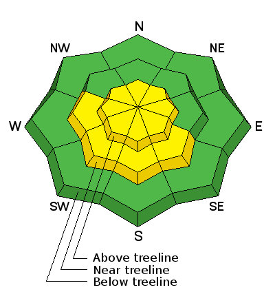
bottom line With daytime heating the avalanche danger will rise to MODERATE on steep, sun exposed slopes. Look for signs of instability such as sloppy, wet snow, or roller balls and pinwheels, and get off of and out from under steep, sun exposed slopes when these signs are present. There also remains an isolated or MODERATE danger for triggering a persistent slab avalanche, or old, hard wind slab on steep, upper elevation northerly facing aspects, primarily in areas of shallow snow, and in rocky, more radical terrain. Elsewhere the avalanche danger is generally LOW.
|
 |
special announcement The Abajo / Blue Mountain advisory provides detailed snow, avalanche and mountain weather conditions on weekends. General information and an overall danger rating will be provided during the week. |
 |
current conditions
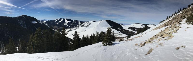
It's a mixed bag of spring like conditions out there. Wind and sun have taken their toll on the snow surface in exposed areas. Soft, powder-like snow can be found on sheltered, shady aspects. Varying degrees of breakable crust can be found on sunny slopes, with supportable corn snow developing on due south aspects.
Winds, temperature and humidity on Abajo Peak. Snow totals at Buckboard Flat. Snow totals at Camp Jackson.
|
 |
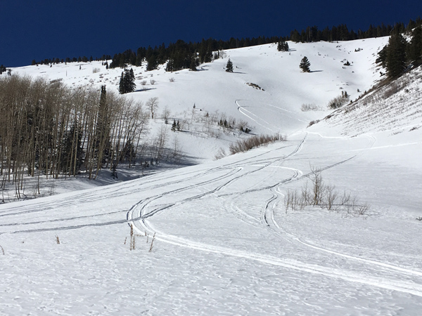
recent activity
|
 |
weather Today Mostly sunny, with a high near 50. Windy, with a south southwest wind 15 to 20 mph increasing to 25 to 30 mph in the afternoon. Winds could gust as high as 40 mph. Tonight A 20 percent chance of snow after 3am. Partly cloudy, with a low around 37. Windy, with a south southwest wind 25 to 30 mph, with gusts as high as 45 mph. Thursday A slight chance of snow before 11am, then a chance of snow showers after 11am. Partly sunny, with a high near 43. Very windy, with a south southwest wind 30 to 40 mph, with gusts as high as 70 mph. Chance of precipitation is 30%. Thursday Night A slight chance of snow showers before 11pm, then a slight chance of snow after 11pm. Mostly cloudy, with a low around 24. Windy, with a west wind 25 to 30 mph becoming light and variable. Winds could gust as high as 50 mph. Chance of precipitation is 20%. Friday Mostly sunny, with a high near 41. Breezy, with a south southwest wind 10 to 20 mph. Friday Night Partly cloudy, with a low around 31. Saturday Sunny, with a high near 43. |
| general announcements Let me know what you are seeing down there by posting an observation here. You can also call me on my cell phone at 801-647-8896 To receive this advisory by email go here. This information does not apply to developed ski areas or highways where avalanche control is normally done. This advisory is from the U.S.D.A. Forest Service, which is solely responsible for its content. This advisory describes general avalanche conditions and local variations always exist. |