| Please join us at the 23rd annual Black Diamond Fall Fundraiser Party Thursday Sept 15. Tickets are on sale now here, at the Black Diamond store & at REI. Special bonus raffle for online ticket purchasers! |
| Please join us at the 23rd annual Black Diamond Fall Fundraiser Party Thursday Sept 15. Tickets are on sale now here, at the Black Diamond store & at REI. Special bonus raffle for online ticket purchasers! |
| Advisory: Abajo Area Mountains | Issued by Bruce Tremper for Sunday - February 7, 2016 - 7:19am |
|---|


|
bottom line There is still a CONSIDERABLE danger of human triggered avalanches today on the upper elevation slopes that did not slide during Monday's storm that face northwest, north, northeast and east. CONSIDERABLE danger means: "Dangerous conditions. Choose conservative terrain." There's a MODERATE danger on any steep slope with recent wind deposits and there is a MODERATE danger for wet, loose avalanches on any of the steep, southerly aspects that are getting wet in the heat of the day.
|
 |
current conditions Hello, this is Bruce Tremper, filling in for Eric Trenbeath, who will be back on Monday. Temperatures warmed up to freezing yesterday and the winds are fairly well behaved today. The roads are plowed and they're in good shape. We got nearly 2 feet of snow from the big storm at the beginning of the week and it's settled into a little over a foot. The snow is rather dense because it came in warm with a lot of rime. With all the wind during and after the storm, it's a bit wind blown on many of the wind exposed slopes but still rides well in the wind sheltered areas. With the strong sun yesterday the sunny aspects are starting to get crusted. Winds, temperature and humidity on Abajo Peak. Snow totals at Buckboard Flat. Snow totals at Camp Jackson.
|
 |
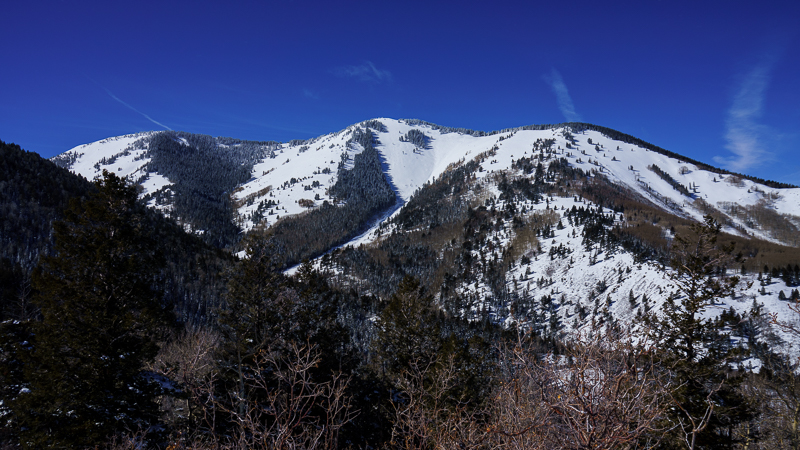
recent activity Although there has not been any recent activity that I know of, there was widespread avalanches during the storm, on Monday. Most of the upper elevation, north through east facing slopes have fracture lines and debris piles at the the bottom. It's a little hard to tell on some of them because they are partially covered up by new snow.
On Horsehead Mountain, I could see fracture lines and debris in many of the upper elevation bowls. Many slides are hard to see because they ran early or in the middle of the storm on Monday and they were covered up by subsequent snow.
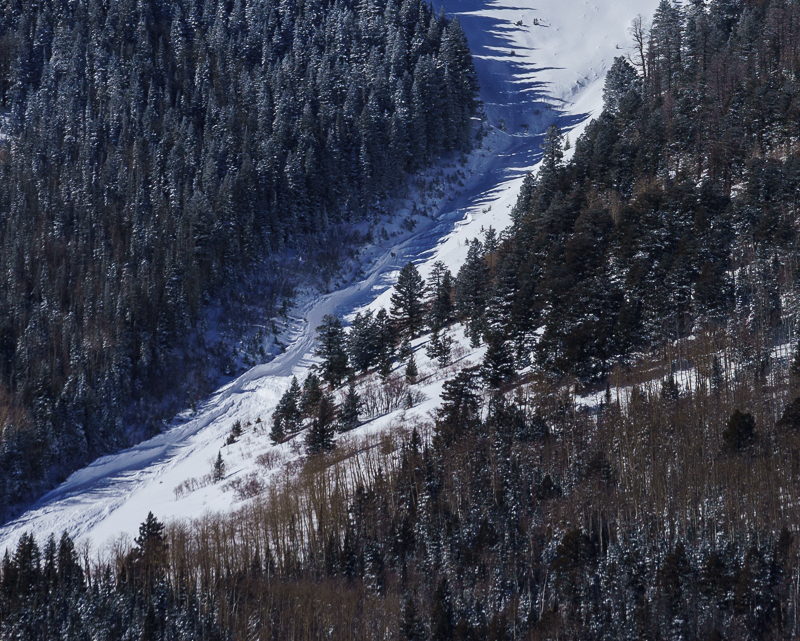
The telltale, fracture lines, roughed-up surface and gouging of a big avalanche.
The impressive debris piles in the gully at the bottom. It would be hard to survive an avalanche in a path like this that funnels down and creates a very deep debris pile. |
| type | aspect/elevation | characteristics |
|---|

|

|
LIKELIHOOD
 LIKELY
UNLIKELY
SIZE
 LARGE
SMALL
TREND
 INCREASING DANGER
SAME
DECREASING DANGER
|
|
description
Monday's storm was quite a wallop of new weight on top of the very fragile, weak layers that developed on the preexisting, snow surface. Yesterday, I could see that widespread avalanches occurred during the storm. See the video below. As we broke trail up yesterday, we could still feel collapsing snow and some of them were big, booming collapses that involved larger areas. And more important, my snow profiles at around 9,300' on a northeast facing slope showed that the new snow is still sensitive and it's producing propagating fractures with not much provocation. This is an avalanche geek's way of saying that you should continue to avoid the steep slopes, especially on the shady aspects where the weak snow formed on the snow surface last week before the big storm hit. Although many of the slopes avalanched during the storm, there are still plenty of slopes left hanging and you may be able to trigger them as well. If you must get onto a steep slope on a shady aspect, do it on a slope that already avalanched during the last storm. Travis Nauman posed an excellent observation from the La Sal Mountains yesterday that confirms what I'm finding as well.
|
| type | aspect/elevation | characteristics |
|---|

|
|
LIKELIHOOD
 LIKELY
UNLIKELY
SIZE
 LARGE
SMALL
TREND
 INCREASING DANGER
SAME
DECREASING DANGER
|
|
description
With plenty of wind during the storm and lots of wind since, there are many wind slabs that could be sensitive to the weight of a person or snowmobile. As always, avoid steep slopes with recent wind deposits. They will looks smooth and rounded. They will also feel "slabby" meaning hard on top with soft snow underneath and they often sound hollow like a drum. The winds blew even at low elevations so you will find them most everywhere.
|
| type | aspect/elevation | characteristics |
|---|

|
|
LIKELIHOOD
LIKELY
UNLIKELY
SIZE
LARGE
SMALL
TREND
INCREASING DANGER
SAME
DECREASING DANGER
|
|
description
It's getting warm enough, and the sun is high enough in the sky, that we are getting wet, loose avalanches in the heat of the day. As always, get off of, and out from underneath, steep slopes when they are getting soggy from the heat of the sun. |
 |
weather We have a high pressure ridge over us for the next week, so we should see lots of sunny skies and warm temperatures. Here's the National Weather Service link to the point forecast for the Abajo Mountains.
|
| general announcements Remember, this is your own, community, avalanche forecast. I can't be everywhere at once, so I critically depend on information from people like you. Let me know what you're seeing. You can view Moab area observations here. To post an observation go here. You can also call me on my cell phone at 801-231-4744 To receive this advisory by email go here. This information does not apply to developed ski areas or highways where avalanche control is normally done. This advisory is from the U.S.D.A. Forest Service, which is solely responsible for its content. This advisory describes general avalanche conditions and local variations always exist. |