| Please join us at the 23rd annual Black Diamond Fall Fundraiser Party Thursday Sept 15. Tickets are on sale now here, at the Black Diamond store & at REI. Special bonus raffle for online ticket purchasers! |
| Please join us at the 23rd annual Black Diamond Fall Fundraiser Party Thursday Sept 15. Tickets are on sale now here, at the Black Diamond store & at REI. Special bonus raffle for online ticket purchasers! |
| Advisory: Abajo Area Mountains | Issued by Eric Trenbeath for Saturday - January 16, 2016 - 6:57am |
|---|

|
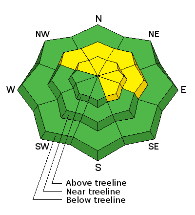
bottom line The avalanche danger is generally MODERATE but areas of elevated concern exist on steep slopes that face NW-N E where the new snow load from last week has added additional stress to buried weak layers in the snowpack. In theses areas, it is possible for the additional weight of a rider to cause a deep and dangerous avalanche. There is also a MODERATE danger for wind slab avalanches in upper elevation, wind exposed terrain. Avoid steep slopes that have recent deposits of wind drifted snow.
|
 |
special announcement The Abajo / Blue Mountain advisory provides detailed snow and avalanche information on weekends, with a general danger rating during the week. |
 |
current conditions Last week's storm really improved things and brought us close to having a real snowpack. We now have between 3-4' of snow on the ground. Wind and sun during the week has crusted over the snow surface in exposed locations, but soft snow still remains in sheltered areas. WNW winds overnight have averaged 15-20 mph with gusts as high as 30. They are currently blowing in the low teens. It's currently 3 degrees on Abajo Peak and 19 at Buckboard Flat. Winds, temperature and humidity on Abajo Peak. Snow totals at Buckboard Flat.
|
 |
recent activity
|
| type | aspect/elevation | characteristics |
|---|

|
|
LIKELIHOOD
 LIKELY
UNLIKELY
SIZE
 LARGE
SMALL
TREND
 INCREASING DANGER
SAME
DECREASING DANGER
|
|
description
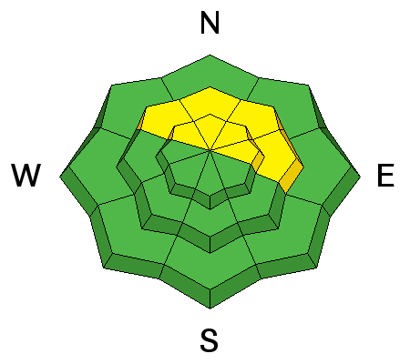
The underlying snowpack is very weak, consisting of sugary faceted snow. The storm snow from last week has settled into place on top but is now waiting for the additional weight of an unsuspecting rider to trigger a deep and dangerous avalanche. This danger exists on steep, northerly facing aspects right around treeline and above. This type of terrain, especially if is featured with gullies, steep roll overs and convexities, should be avoided for awhile.
|
| type | aspect/elevation | characteristics |
|---|

|
|
LIKELIHOOD
 LIKELY
UNLIKELY
SIZE
 LARGE
SMALL
TREND
 INCREASING DANGER
SAME
DECREASING DANGER
|
|
description
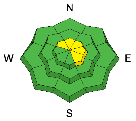
Isolated, stiff wind slabs exist on the lee sides of upper elevation ridge crests and terrain features. A triggered wind slab has the potential to step down into buried weak layers creating a dangerous deep slab avalanche that could run to the ground. Avoid areas of wind deposited snow recognizable by their smooth, rounded appearance. |
 |
weather Today A 30 percent chance of snow, mainly after 4pm. Increasing clouds, with a high near 22. West northwest wind 10 to 15 mph. Tonight A 30 percent chance of snow, mainly before 1am. Mostly cloudy, with a low around 15. Northwest wind around 15 mph. Sunday A 20 percent chance of snow. Partly sunny, with a high near 26. Northwest wind around 15 mph. Sunday Night Mostly cloudy, with a low around 15. Northwest wind around 15 mph, with gusts as high as 25 mph. M.L.King Day Partly sunny, with a high near 30. Breezy, with a west southwest wind 20 to 25 mph, with gusts as high as 35 mph. |
| general announcements This advisory is from the U.S.D.A. Forest Service, which is solely responsible for its content. This advisory describes general avalanche conditions and local variations always exist. |


