| Please join us at the 23rd annual Black Diamond Fall Fundraiser Party Thursday Sept 15. Tickets are on sale now here, at the Black Diamond store & at REI. Special bonus raffle for online ticket purchasers! |
| Please join us at the 23rd annual Black Diamond Fall Fundraiser Party Thursday Sept 15. Tickets are on sale now here, at the Black Diamond store & at REI. Special bonus raffle for online ticket purchasers! |
| Advisory: Abajo Area Mountains | Issued by Eric Trenbeath for Sunday - January 10, 2016 - 6:29am |
|---|


|
bottom line The avalanche danger is generally MODERATE but areas of CONSIDERABLE danger still exist on steep slopes right around tree line and above that face NW-N-E-SE. In these areas, there remains a high likelihood for human triggered avalanches. Stick to lower angle slopes, or slopes with a different aspect for safer riding today.
|
 |
current conditions A surprise storm late Thursday night and early Friday morning dumped between 14" and 24" of light, fluffy powder on the Abajo / Blue Mountains. Reports from yesterday indicate that the snow is settling out, but lots of sleds were getting stuck up in North Creek. Skiers, displaced by the Geyser Pass road closure, tracked out the old Blue Mountain Ski Area on Friday, and began pushing up the ridge toward Abajo Peak yesterday. Check out these observations from Matt Van Scoyoc and Brian Sparks. Winds during and after the storm have remained mostly calm, occasionally gusting into the 15-20 mph range along ridge tops. Direction varied from SW during the storm to NE after. They are currently in the single digits and westerly. It is a frigid 1 degree on Abajo Peak, and 7 at Buckboard Flat. Winds, temperature and humidity on Abajo Peak. Snow totals at Buckboard Flat.
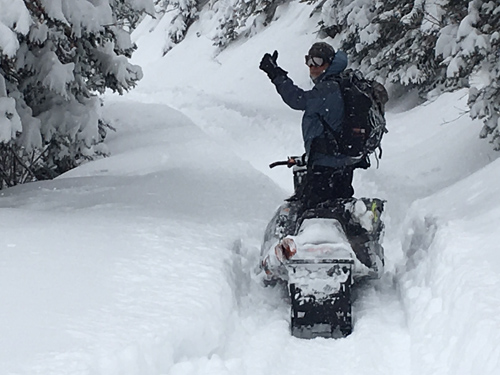
Note to self: Don't stop unless you have a good place to turnaround which, in lower North Creek, is nowhere. We made it to just below the first big switchback on Friday where deep snow and the threat of avalanches turned us around.
Observer Brian Murray gives the thumbs up on the way back down.
|
 |
recent activity
|
| type | aspect/elevation | characteristics |
|---|

|
|
LIKELIHOOD
 LIKELY
UNLIKELY
SIZE
 LARGE
SMALL
TREND
 INCREASING DANGER
SAME
DECREASING DANGER
|
|
description
This first significant load test on our fragile, weak snowpack failed to produce any avalanche activity. But the situation is akin to adding straw to the camel's back. The underlying snow was very shallow, and is comprised of weak, loose, sugary snow called facets. In some cases, these weak facets had old, hard wind slabs on top of them. The new snow has increased the stress on the underlying weak snow, and is now hanging in a state of suspension waiting for a trigger. That trigger would likely come in the form of an unwary rider. Today, there remains a a high probability for triggering a deep and dangerous persistent slab avalanche on upper elevation slopes, steeper than 35 degrees, that face NW-N-E-SE.
Weak, sugary facets underlay most of the snowpack providing an unstable base for the new load of snow.
|
| type | aspect/elevation | characteristics |
|---|

|

|
LIKELIHOOD
 LIKELY
UNLIKELY
SIZE
 LARGE
SMALL
TREND
INCREASING DANGER
SAME
DECREASING DANGER
|
|
description
Isolated wind drifts have formed along upper elevation ridge crests and terrain features. Be on the lookout for smooth, rounded pillows that may crack out in front of you. Avoid steep slopes where this condition is present. A wind slab triggered has the potential to step down into buried weak layers causing a deeper and more dangerous persistent slab avalanche. |
 |
weather High pressure and dry conditions will develop over our area for the upcoming week. Today A 30 percent chance of snow, mainly before 4pm. Mostly cloudy, with a high near 17. North northwest wind 5 to 10 mph. Tonight A 10 percent chance of snow before 3am. Partly cloudy, with a low around 9. South wind around 15 mph. Monday Sunny, with a high near 20. Northeast wind around 15 mph becoming north northwest in the afternoon. Monday Night Mostly clear, with a low around 9. North wind 5 to 10 mph. Tuesday Sunny, with a high near 27. North wind 5 to 10 mph. Tuesday Night Mostly clear, with a low around 15. Wednesday Mostly sunny, with a high near 24. |
| general announcements This advisory is from the U.S.D.A. Forest Service, which is solely responsible for its content. This advisory describes general avalanche conditions and local variations always exist. |