| Please join us at the 23rd annual Black Diamond Fall Fundraiser Party Thursday Sept 15. Tickets are on sale now here, at the Black Diamond store & at REI. Special bonus raffle for online ticket purchasers! |
| Please join us at the 23rd annual Black Diamond Fall Fundraiser Party Thursday Sept 15. Tickets are on sale now here, at the Black Diamond store & at REI. Special bonus raffle for online ticket purchasers! |
| Advisory: Abajo Area Mountains | Issued by Eric Trenbeath for Saturday - January 9, 2016 - 6:37am |
|---|

|
bottom line A large amount of new snow has increased the avalanche danger to CONSIDERABLE on all slopes of all aspects at and above tree line. Human triggered avalanches are likely, and natural avalanches are possible. Upper elevation slopes that face northwest through east harbor the greatest danger, and avalanches in these areas are likely to break to the ground. Low elevation slopes have a moderate danger. Backcountry travelers need good terrain and snowpack stability evaluation skills, and conservative decision making is a must for safe travel this weekend.
|
 |
special avalanche bulletin A fast moving storm system brought heavy snowfall to the Abajo Mountains yesterday. The new snow has added a significant load to a shallow and weak snow pack, and dangerous avalanche conditions exist. |
 |
current conditions The Abajo/Blue Mountains just got walloped. A forecasted 3-5" of new snow turned into 14" at Buckboard Flat, and as much as 2' of relatively light, low density snow at upper elevations. Winds during the storm remained mostly calm and the snow fell straight out of the sky. In short, deep powder snow covers the range. For most of the day yesterday, ridge top winds averaged around 10 mph from the NE with occasional gusts into the teens. They remain calm this morning, averaging 5-10 mph from the WNW. It's currently 19 degrees as Buckboard Flat and a frigid 6 degrees on Abajo Peak. Winds, temperature and humidity on Abajo Peak. Snow totals at Buckboard Flat.
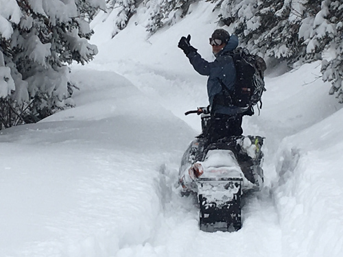
Note to self: Don't stop unless you have a good place to turnaround which, in lower North Creek, is nowhere. We made it to just below the first big switchback where deep snow and the threat of avalanches turned us around.
Observer Brian Murray gives the thumbs up on the way back down.
|
 |
recent activity We weren't able to get very high up to look for recent avalanche activity, but we did get a good look at the Horse Head slide path which hadn't run. Otherwise, we observed some instability in the new snow in the form of loose snow sluffs, and soft storm slab releases from steep road banks.
|
| type | aspect/elevation | characteristics |
|---|

|
|
LIKELIHOOD
 LIKELY
UNLIKELY
SIZE
 LARGE
SMALL
TREND
 INCREASING DANGER
SAME
DECREASING DANGER
|
|
description
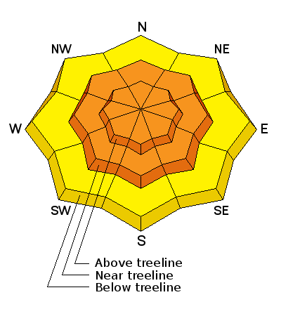
This is the first significant load test on our fragile, weak snowpack. If this load hasn't tipped the balance, it is very likely that the additional weight of a rider will. Human triggered avalanches are almost certain this weekend on slopes steeper than about 35 degrees, and a slide triggered will likely step down to the sugary, faceted snow at the ground resulting in a deep and dangerous, full depth avalanche. Slides may also be triggered from low angle, connected slopes. Practice safe travel techniques and stay off of, and out from under, steep slopes this weekend.
|
| type | aspect/elevation | characteristics |
|---|

|

|
LIKELIHOOD
 LIKELY
UNLIKELY
SIZE
 LARGE
SMALL
TREND
 INCREASING DANGER
SAME
DECREASING DANGER
|
|
description
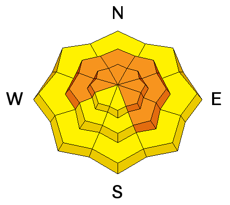
Until the new snow has time to settle, human triggered avalanches within the new snow are likely on all aspects steeper than 35 degrees. Once triggered, new snow avalanches have the potential to step down into buried, weak, sugary snow at the ground resulting in a full depth, persistent slab avalanche. |
 |
weather Today A slight chance of snow between 10am and 1pm. Mostly sunny, with a high near 19. Northwest wind 5 to 10 mph. Chance of precipitation is 10%. Tonight A slight chance of snow between 10pm and 3am. Mostly cloudy, with a low around 9. West northwest wind 5 to 10 mph. Chance of precipitation is 10%. Sunday Partly sunny, with a high near 15. North northwest wind 5 to 10 mph. Sunday Night Partly cloudy, with a low around 5. North wind 5 to 10 mph. Monday Mostly sunny, with a high near 17. North northwest wind 5 to 15 mph. |
| general announcements This advisory is from the U.S.D.A. Forest Service, which is solely responsible for its content. This advisory describes general avalanche conditions and local variations always exist. |