| Please join us at the 23rd annual Black Diamond Fall Fundraiser Party Thursday Sept 15. Tickets are on sale now here, at the Black Diamond store & at REI. Special bonus raffle for online ticket purchasers! |
| Please join us at the 23rd annual Black Diamond Fall Fundraiser Party Thursday Sept 15. Tickets are on sale now here, at the Black Diamond store & at REI. Special bonus raffle for online ticket purchasers! |
| Advisory: Abajo Area Mountains | Issued by Eric Trenbeath for Saturday - December 26, 2015 - 7:07am |
|---|

|
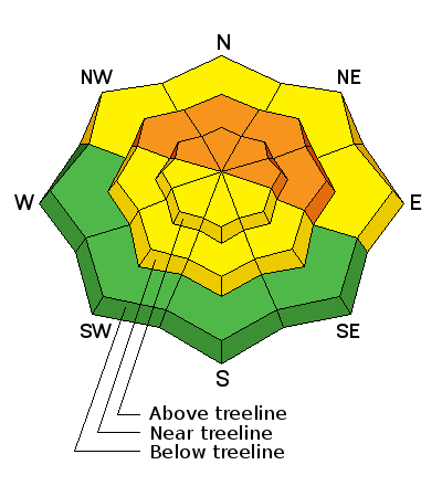
bottom line The avalanche danger remains CONSIDERABLE on steep, northerly facing aspects, and in areas where you can detect recent deposits of wind drifted snow. Riders should watch their slope angles and stay off of an out from under steep terrain this weekend. The avalanche danger is MODERATE on south facing terrain and at lower elevations.
|
 |
current conditions About 6" of new snow fell across the range, and though we haven't been getting the big dumps, conditions continue to steadily improve with a base of around 24" at Buckboard Flat and over 3' at upper elevations. Southwest winds were remarkably well behaved throughout the storm blowing in the single digits with gusts into the teens for most of the day yesterday. This morning they are averaging less than 10 mph with gusts into the 20's from the northwest. It's a very wintry 8 degrees at Buckboard Flat and -4 on top of Abajo Peak. Winds, temperature and humidity on Abajo Peak. Snow totals at Buckboard Flat.
|
| type | aspect/elevation | characteristics |
|---|

|
|
LIKELIHOOD
 LIKELY
UNLIKELY
SIZE
 LARGE
SMALL
TREND
 INCREASING DANGER
SAME
DECREASING DANGER
|
|
description
New snow has been accumulating on top of a very weak, pre-existing snowpack. It's really a matter of stress overriding strength, and in this case, the stress will likely come from the weight of a rider. Right now, there exists a high likelihood for human triggered avalanches on steep, upper elevation, northerly facing aspects. Avalanches triggered in these areas have the potential to run deep, taking out the entire snowpack, and a ride in one of these slides would be rough as you are swept across surface of the ground. Stick to lower angle terrain and stay off of areas with deep drifted snow.
|
 |
weather Today A 50 percent chance of snow, mainly before 1pm. Partly sunny and cold, with a high near 8. Wind chill values as low as -20. Blustery, with a north northwest wind 15 to 25 mph, with gusts as high as 40 mph. Total daytime snow accumulation of around an inch possible. Tonight A 10 percent chance of snow before 8pm. Partly cloudy, with a low around 0. Wind chill values as low as -15. Northeast wind around 15 mph. Sunday Sunny, with a high near 16. Wind chill values as low as -15. North wind around 10 mph. Sunday Night Partly cloudy, with a low around -1. Wind chill values as low as -20. Northeast wind around 10 mph becoming south southwest after midnight. Monday Mostly sunny, with a high near 12. South southwest wind 10 to 15 mph. |
| general announcements This advisory is from the U.S.D.A. Forest Service, which is solely responsible for its content. This advisory describes general avalanche conditions and local variations always exist. |


