| Please join us at the 23rd annual Black Diamond Fall Fundraiser Party Thursday Sept 15. Tickets are on sale now here, at the Black Diamond store & at REI. Special bonus raffle for online ticket purchasers! |
| Please join us at the 23rd annual Black Diamond Fall Fundraiser Party Thursday Sept 15. Tickets are on sale now here, at the Black Diamond store & at REI. Special bonus raffle for online ticket purchasers! |
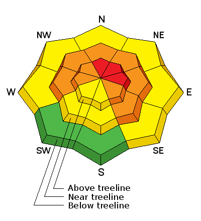
| Advisory: Abajo Area Mountains | Issued by Eric Trenbeath for Tuesday - December 22, 2015 - 7:26am |
|---|

|
bottom line Expect the danger to rise to HIGH today as new snow and wind combine to create unstable avalanche conditions, particularly on upper mid to upper elevation northerly facing aspects. Stay off of and out from under steep slopes today. Backcountry travel is not recommended for folks who do not have excellent route finding and avalanche awareness skills.
|
 |
avalanche watch AVALANCHE WATCH THE FOREST SERVICE UTAH AVALANCHE CENTER IN MOAB UTAH HAS ISSUED A BACKCOUNTRY AVALANCHE WATCH. * TIMING…IN EFFECT FROM 6 PM MST MONDAY EVENING TO 6 AM MST WEDNESDAY MORNING * AFFECTED AREA…FOR THE MOUNTAINS OF SOUTHEASTERN UTAH INCLUDING THE LA SAL...ABAJO MOUNTAINS * AVALANCHE DANGER…THE AVALANCHE DANGER FOR THE WARNING AREA WILL RISE TONIGHT AND WILL LIKELY BE HIGH BY TUESDAY. * REASON…HEAVY SNOW COMBINED WITH WIND WILL LIKELY CREATE WIDESPREAD AREAS OF UNSTABLE SNOW. BOTH HUMAN TRIGGERED AND NATURAL AVALANCHES ARE ANTICIPATED TO BE LIKELY ON SLOPES STEEPER THAN ABOUT 30 DEGREES. |
 |
current conditions
|
 |
weather Today Snow. Areas of blowing snow. High near 24. Breezy, with a west southwest wind 20 to 25 mph, with gusts as high as 35 mph. Chance of precipitation is 100%. Total daytime snow accumulation of 3 to 5 inches possible. Tonight Snow, mainly before 3am. Areas of blowing snow. Low around 14. Blustery, with a west northwest wind around 20 mph, with gusts as high as 30 mph. Chance of precipitation is 90%. New snow accumulation of 2 to 4 inches possible. Wednesday A 50 percent chance of snow. Areas of blowing snow. Mostly cloudy, with a high near 19. Blustery, with a west northwest wind around 20 mph, with gusts as high as 30 mph. New snow accumulation of 2 to 4 inches possible. Wednesday Night A 20 percent chance of snow. Areas of blowing snow. Mostly cloudy, with a low around 5. Wind chill values as low as -15. Blustery, with a west northwest wind 15 to 25 mph. Thursday A 40 percent chance of snow, mainly after 11am. Areas of blowing snow. Cloudy, with a high near 17. Breezy, with a southwest wind 15 to 20 mph. Thursday Night Snow likely. Areas of blowing snow. Cloudy, with a low around 15. Breezy. Chance of precipitation is 70%. Christmas Day Snow likely. Areas of blowing snow. Cloudy, with a high near 19. Windy. Chance of precipitation is 70%. |
| general announcements This advisory is from the U.S.D.A. Forest Service, which is solely responsible for its content. This advisory describes general avalanche conditions and local variations always exist. |


