| Please join us at the 23rd annual Black Diamond Fall Fundraiser Party Thursday Sept 15. Tickets are on sale now here, at the Black Diamond store & at REI. Special bonus raffle for online ticket purchasers! |
| Please join us at the 23rd annual Black Diamond Fall Fundraiser Party Thursday Sept 15. Tickets are on sale now here, at the Black Diamond store & at REI. Special bonus raffle for online ticket purchasers! |
| Advisory: Abajo Area Mountains | Issued by Eric Trenbeath for Sunday - December 20, 2015 - 7:37am |
|---|


|
bottom line Today there is a CONSIDERABLE avalanche danger on slopes steeper than 35 degrees in upper elevation, wind exposed terrain, particularly on slopes with a NW-N-E aspect and riders should avoid these areas today. Choose terrain at lower elevations or with a different aspect for safer riding options today.
|
 |
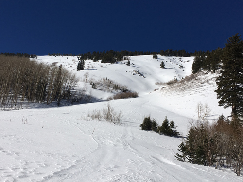
current conditions Southerly winds that averaged in the 20-30 mph range yesterday have tapered off this morning and are averaging 15-20. It is currently 30 degrees at Buckboard Flat and 13 on Abajo Peak. It's still pretty thin but the storm from earlier this week is a vast improvement. All told, the mountains picked up 12-18" of new snow that has now settled to half that. Base depth varies from about 23" at Buckboard flat to about 30" at North Creek Pass. There are still plenty of obstacles lying just beneath the surface, especially on sun exposed slopes that were nearly bare ground prior to this storm. Excellent powder conditions remain in sheltered areas, but a strong sun and warm temperatures have crusted over sun exposed aspects.
Winds, temperature and humidity on Abajo Peak. Snow totals at Buckboard Flat.
Conditions are improving but it is still thin.
This tree is down over the road just below North Creek Pass.
|
| type | aspect/elevation | characteristics |
|---|

|

|
LIKELIHOOD
 LIKELY
UNLIKELY
SIZE
 LARGE
SMALL
TREND
 INCREASING DANGER
SAME
DECREASING DANGER
|
|
description
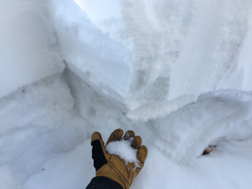
In my travels on Friday, I observed lots of collapsing of the snowpack, a sure sign of instability that means the new snow load isn't sitting very well on top of the underlying, weak, sugary, faceted snow that was on the ground before the storm. What this means is that the weight of a rider will likely trigger a persistent slab avalanche on upper elevation slopes that face the north half of the compass that are steeper than 35 degrees. As winds begin to move snow around, fresh wind drifts will add additional stress to these slopes making them even more dangerous. On slopes that are well anchored, meaning that you can still see lots of grass and or bushes sticking out, this danger is not as likely. Stick to slopes such as this, or ones that face the south half of the compass today, stay down at lower elevations.
Very weak, sugary snow called facets is creating a very unstable base for new snow.
|
| type | aspect/elevation | characteristics |
|---|

|

|
LIKELIHOOD
 LIKELY
UNLIKELY
SIZE
LARGE
SMALL
TREND
INCREASING DANGER
SAME
DECREASING DANGER
|
|
description
Winds over the past 24 hours have drifted snow and deposited new, stiff wind slabs on the lee sides of ridge crests and terrain features in exposed, upper elevation terrain that faces NW-E-SE. Be alert to signs of instability of such as cracking or collapsing. A triggered wind slab also has the danger of stepping down into buried weak layers causing a larger and more dangerous persistent slab avalanche. |
 |
weather An unsettled weather pattern is on tap for the week with our first chance at some snow looking like Monday into Tuesday. A series of systems will then move through the area with one on Christmas Day looking like the biggest hitter. Today A slight chance of snow between 11am and 4pm. Partly sunny, with a high near 33. Southwest wind 5 to 15 mph. Chance of precipitation is 20%. Tonight Mostly cloudy, with a low around 21. South southwest wind around 10 mph. Monday A 30 percent chance of snow, mainly after 4pm. Partly sunny, with a high near 34. South wind 5 to 10 mph. Monday Night A 40 percent chance of snow, mainly after 11pm. Mostly cloudy, with a low around 25. Breezy, with a south southwest wind 10 to 15 mph increasing to 15 to 20 mph after midnight. Tuesday A 50 percent chance of snow. Mostly cloudy, with a high near 35. Breezy, with a southwest wind 15 to 20 mph, with gusts as high as 30 mph. Tuesday Night A 40 percent chance of snow. Mostly cloudy, with a low around 25. Breezy. Wednesday A 40 percent chance of snow. Mostly cloudy, with a high near 32. |
| general announcements This advisory is from the U.S.D.A. Forest Service, which is solely responsible for its content. This advisory describes general avalanche conditions and local variations always exist. |