| Please join us at the 23rd annual Black Diamond Fall Fundraiser Party Thursday Sept 15. Tickets are on sale now here, at the Black Diamond store & at REI. Special bonus raffle for online ticket purchasers! |
| Please join us at the 23rd annual Black Diamond Fall Fundraiser Party Thursday Sept 15. Tickets are on sale now here, at the Black Diamond store & at REI. Special bonus raffle for online ticket purchasers! |
| Advisory: Abajo Area Mountains | Issued by Eric Trenbeath for Tuesday - December 15, 2015 - 7:24am |
|---|

|
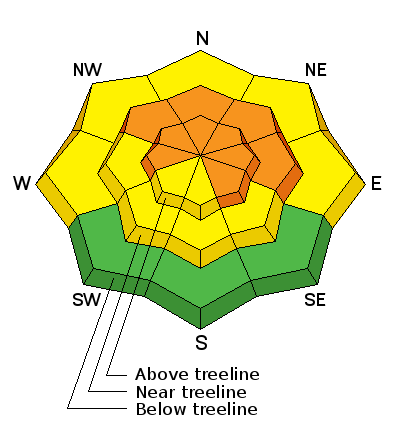
bottom line Today there is a CONSIDERABLE avalanche danger on slopes steeper than 35 degrees. This means that human triggered avalanches are likely and natural avalanches are possible. Only experienced backcountry travelers, with excellent route findings skills, should venture into areas of avalanche terrain today.
|
 |
current conditions The mountains picked up 10-12" of very low density snow from this storm, and we'll take it! The first wave brought in about 4" of snow yesterday, and things picked up in earnest around 5:00 p.m. snowing until around midnight. Winds early in the storm were in the 15-20 mph range from the SE but since about 4:00 pm yesterday they have been in the single digits from the SW shifting to westerly this morning. It is a currently 1 degree on Abajo Peak and 15 at Buckboard Flat. The new snow has fallen on a very thin and shallow snowpack, and in some cases, bare ground and many obstacles will be lurking beneath the surface. Winds, temperature and humidity on Abajo Peak. Snow totals at Buckboard Flat.
|
| type | aspect/elevation | characteristics |
|---|

|
|
LIKELIHOOD
 LIKELY
UNLIKELY
SIZE
 LARGE
SMALL
TREND
 INCREASING DANGER
SAME
DECREASING DANGER
|
|
description
The new snow has landed on very weak, shallow, sugary snow that existed on the ground prior to the storm. Needless to say, it is a very unstable base for the additional snow load and persistent slab avalanches are likely. Slides would likely break 2-3 deep at the ground entraining a considerable amount of snow and taking you for rough and rocky ride over the ground surface. Riders today without excellent route finding and avalanche awareness skills should avoid mountain travel today.
|
 |
weather The storm is slowly moving eastward and as the flow shifts to northwest, we will see drier and colder air though snow showers are likely to linger into tomorrow with another 1-3" possible today. Northwest winds will be on the increase, blowing from 10-20 mph, and it is going to be cold. High temps at 10,000' will be around 11 degrees, but with wind chill it will feel like minus 15. Today Snow likely, mainly before 2pm. Cloudy, with a high near 13. Wind chill values as low as -15. Blustery, with a northwest wind 10 to 15 mph increasing to 15 to 20 mph in the morning. Winds could gust as high as 35 mph. Chance of precipitation is 60%. Total daytime snow accumulation of 1 to 3 inches possible. Tonight A 30 percent chance of snow, mainly before 8pm. Mostly cloudy, with a low around 10. Northwest wind 10 to 15 mph. Wednesday Mostly sunny, with a high near 15. Northwest wind 10 to 15 mph. Wednesday Night Partly cloudy, with a low around 5. Wind chill values as low as -15. Northwest wind around 15 mph. Thursday Mostly sunny, with a high near 17. West northwest wind around 15 mph, with gusts as high as 25 mph. Thursday Night Partly cloudy, with a low around 11. Friday Sunny, with a high near 22. |
| general announcements This advisory is from the U.S.D.A. Forest Service, which is solely responsible for its content. This advisory describes general avalanche conditions and local variations always exist. |


