| Please join us at the 23rd annual Black Diamond Fall Fundraiser Party Thursday Sept 15. Tickets are on sale now here, at the Black Diamond store & at REI. Special bonus raffle for online ticket purchasers! |
| Please join us at the 23rd annual Black Diamond Fall Fundraiser Party Thursday Sept 15. Tickets are on sale now here, at the Black Diamond store & at REI. Special bonus raffle for online ticket purchasers! |
| Advisory: Abajo Area Mountains | Issued by Eric Trenbeath for Monday - December 14, 2015 - 6:01am |
|---|

|
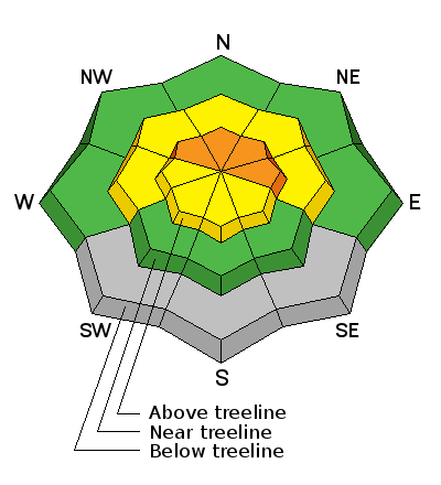
bottom line Expect a rising hazard today as new snow accompanied by wind, could push the avalanche danger to CONSIDERABLE at and above tree line. This means that natural avalanches are possible and human triggered avalanches are likely. Backcountry travelers should avoid steep terrain today, particularly on slopes that face the north half of the compass. This danger applies both to recently deposited wind slabs, and deeper, persistent slab avalanches. Outside of the wind zone the avalanche danger is MODERATE today.
|
 |
current conditions A decent storm is on our doorstep, but as of 5:00 a.m. snow had not yet begun to fall. By mid morning we should see a period of heavy snow. Forecasted totals aren't overly impressive, but we could see up to 6" today and a few more inches tonight. Overnight winds have been on the increase, averaging 15-20 mph from the SW and then switching to the SE at 25 mph with gusts to 40. It's currently 24 degrees at Buckboard Flat and 14 on Abajo Peak. The new snow will be falling on a very thin and shallow snowpack, and in some cases, bare ground. Known grassy slopes or meadows will offer the the only reasonable off trail riding today. Winds, temperature and humidity on Abajo Peak. Snow totals at Buckboard Flat.
|
| type | aspect/elevation | characteristics |
|---|

|
|
LIKELIHOOD
 LIKELY
UNLIKELY
SIZE
 LARGE
SMALL
TREND
 INCREASING DANGER
SAME
DECREASING DANGER
|
|
description
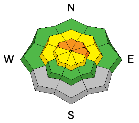
Today is one off those days where you will need to be alert to a rising avalanche danger as the day progresses. New snow will be blown into sensitive drifts on the lee sides of ridge crests and terrain features in wind exposed terrain. The danger will be most pronounced on slopes facing the north half of the compass and you should stay off of, and out from under, steep terrain on these aspects. If triggered, new wind slabs will have the potential to step down into older weaker snow causing a deeper and more dangerous persistent slab avalanche.
|
| type | aspect/elevation | characteristics |
|---|

|
|
LIKELIHOOD
 LIKELY
UNLIKELY
SIZE
LARGE
SMALL
TREND
INCREASING DANGER
SAME
DECREASING DANGER
|
|
description
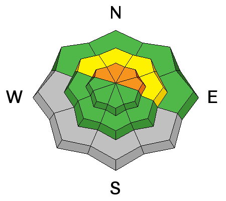
The existing snowpack is very weak and sugary consisting mostly of faceted snow. Simply put, it is a very unstable base for supporting new snow. Under these conditions, the potential exists for triggering a persistent slab avalanche, one to two feet deep down to the ground level, as a result of this buried weak snow. The danger will be most pronounced on slopes facing the north half of the compass and you should stay off of, and out from under, steep terrain on these aspects. |
 |
weather A deepening storm system will move through our area today and linger into tomorrow. This morning should see periods of heavy snow with 4-8" possible decreasing by this afternoon. We could see another 2-4" tonight. High temperatures at 10,000' will be around 15 degrees, and winds will be from the SW at 15- 20 mph gusting to 30. Showers may linger into Tuesday. Monday Snow. High near 17. Breezy, with a south southwest wind 15 to 20 mph, with gusts as high as 30 mph. Chance of precipitation is 100%. New snow accumulation of 4 to 8 inches possible. Monday Night Snow. Low around 5. Northwest wind around 15 mph. Chance of precipitation is 90%. New snow accumulation of 2 to 4 inches possible. Tuesday Snow likely, mainly before 11am. Cloudy, with a high near 11. Wind chill values as low as -10. North northwest wind 10 to 15 mph, with gusts as high as 25 mph. Chance of precipitation is 60%. New snow accumulation of 1 to 3 inches possible. Tuesday Night A 30 percent chance of snow, mainly before 11pm. Mostly cloudy, with a low around 3. Northwest wind around 15 mph. Wednesday Mostly sunny, with a high near 15. |
| general announcements This advisory is from the U.S.D.A. Forest Service, which is solely responsible for its content. This advisory describes general avalanche conditions and local variations always exist. |


