Forecast for the Uintas Area Mountains

Craig Gordon
Issued by Craig Gordon for
Wednesday, December 12, 2018
In the wind zone in mid and upper elevation terrain at and above treeline, the avalanche danger is CONSIDERABLE. Human triggered avalanches are likely in steep, wind drifted terrain, especially on slopes facing the north half of the compass. In addition, while becoming harder to initiate, human triggered avalanches breaking into deeper, buried weak layers is a distinct possibility, particularly on any steep slope harboring old snow near the ground. Remember- triggering a slide that breaks to old snow will have severe consequences.
Swing around to the south half of the compass to slopes with no old snow near the ground and the avalanche danger drops dramatically.
Low
Moderate
Considerable
High
Extreme
Learn how to read the forecast here
Special Announcements
Check out the new free online avalanche course series developed by the Utah Avalanche Center. This is a great way to refresh your skills or prepare you for a Backcountry 101 or Level 1 class. https://kbyg.org/learn/
Huge thanks to Park City Professional Ski Patrol Association for hosting last nights avy awareness presentation and to all of you who joined us.
Tonight at 7:00 I'll be talking about current conditions at-
Freeheel Life
3485 S West Temple, Salt Lake City, Utah 84115
Weather and Snow
Clouds are streaming into the region, ahead of a quick hitting storm slated to impact the area later this morning. Currently, temperatures are in the teens and low 20's. South and southwest winds are humming in the 20's and 30's along the high peaks. Recent storms have been good to the eastern front and the Uinta's are white. Riding and turning conditions are about the best they've been in years with snow depths across the range averaging just over 3'.
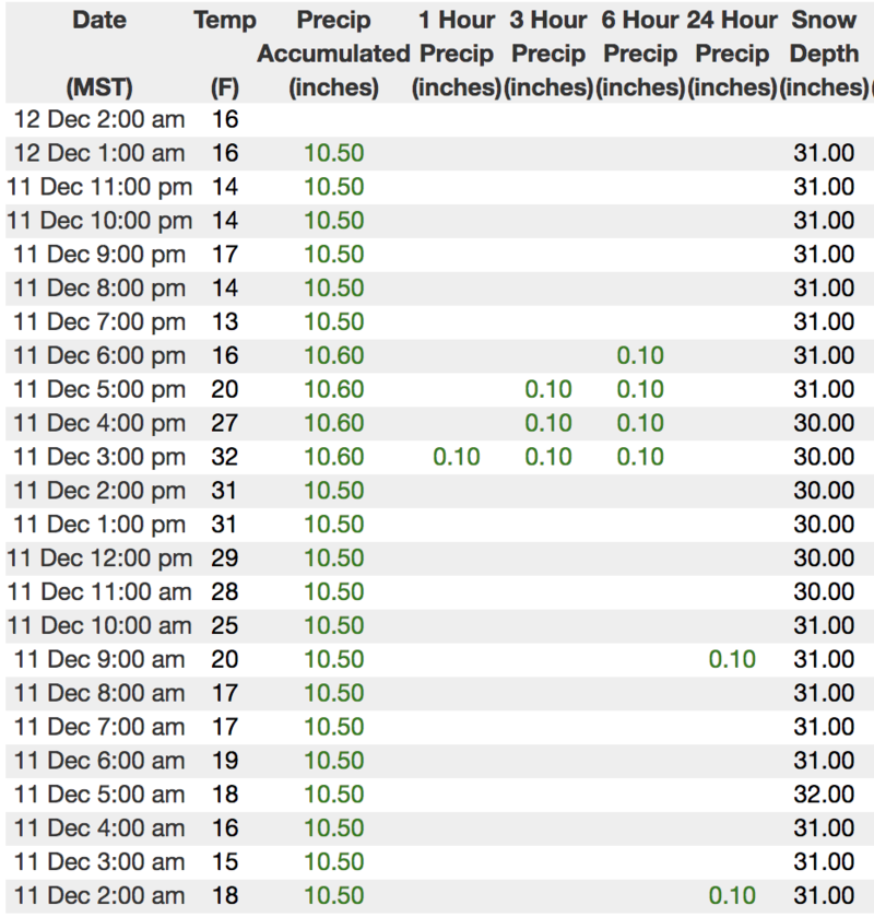
We are working to get the entire Uinta weather network back online, but got Windy Peak up and running last week. Above is recent hourly data from Trial Lake (9,945') along with wind data from Windy Peak (10,662'). To view more regional weather stations click here.
Plowing is done on Mirror Lake Highway, but Wolf Creek Pass is still open. A lot of people where out over the weekend and many steep slopes surrounding the pass were ridden hard and without incident. However, just 'cause you can see your rig parked near Wolf Creek, doesn't mean the terrain you're choosing to ride is good to go. Remember- if you are getting out and about, be prepared for your own self rescue. Wear and know how to use an avalanche beacon, shovel, and probe.
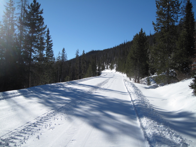
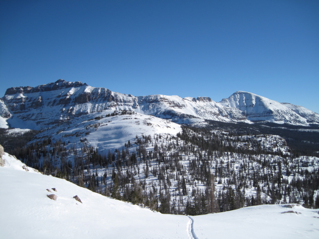
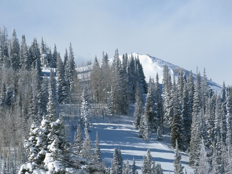
White, winter pavement brings you to some amazing sights on the eastern front.
The big peaks near the Mirror Lake Highway lookin' mighty white these days.
Recent Avalanches
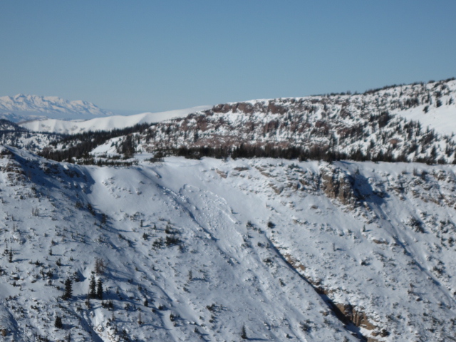
Yesterday, Ted spotted an old slide on a steep, wind drifted slope of Mt. Marsell.
Otherwise, no significant new avalanche activity to report from the eastern front.
This seasons snowpack and avalanche observations, along with trip reports are found here.
Ad
Avalanche Problem #1
Persistent Weak Layer
Type
Location
Likelihood
Size
Description
The past few days of warmth have been good to our snowpack and I'm encouraged by what I'm seeing, particularly in zones where the pack is getting deeper. In other good news... we haven't heard of or seen any significant avalanche activity for just over a week. Now, here's where it gets a little tricky. The Uinta's are a big range and there's lots of variables when it comes to snowpack depth and strength. Remember- "persistent weak layers" in the snowpack are a headache because they remain problem children for long periods of time. And all we need to do is find one weakness, maybe around a bush or rock that we can't see buried underneath the snow, collapse the pack, and now we're staring down the barrel of a scary avalanche. The usual suspect terrain comes to mind. Steep, rocky slopes with a shallow snowpack. So the way I'm avoiding this scenario is by simply avoiding the terrain where this setup exists.... mid and upper elevation, north facing slopes that harbored snow prior to the big Thanksgiving storm. There's a lot of terrain to ride today and not have to deal with unmanageable avalanche conditions, IF you chose slopes that had NO old snow prior to the big Thanksgiving storm.
JG was in the Wolf Creek environs over the weekend. His beautifully detailed pit profile above accurately illustrates our snowpack on the south half of the range.
Avalanche Problem #2
Wind Drifted Snow
Type
Location
Likelihood
Size
Description
Today's winds will have a dose of light density snow to work with and this combo will form fresh drifts sensitive to our additional weight. Found mostly on steep mid and upper elevation leeward slopes (like in the image above), as always, don't let your guard down. Be on the lookout for and avoid any fat, rounded piece of snow especially if it sounds hollow like a drum.
Additional Information
A fast moving storm system slides through the region this morning and we should see a quick burst of snow. Storm totals look to be in the 6" range. Winds switch to the northwest with frontal passage and blow in the 30's and 40's along the high ridges. High temperatures reach into the mid 20's and overnight lows dip into the teens. High pressure builds for the latter half of the week.
General Announcements
The information in this advisory expires 24 hours after the date and time posted, but will be updated by 7:00 AM Thursday December 13th, 2018.
If you're getting out and about, please let me know what you're seeing especially if you see or trigger and avalanche. I can be reached at [email protected] or 801-231-2170
It's also a good time to set up one of our very popular avalanche awareness classes. Reach out to me and I'll make it happen.
This information does not apply to developed ski areas or highways where avalanche control is normally done. This advisory is from the U.S.D.A. Forest Service, which is solely responsible for its content. This advisory describes general avalanche conditions and local variations always occur.