Forecast for the Moab Area Mountains

Eric Trenbeath
Issued by Eric Trenbeath for
Saturday, February 2, 2019
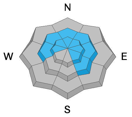
The avalanche danger is MODERATE today, but deep and dangerous, human triggered avalanches, failing on a buried persistent weak layer are still possible. You are most likely to encounter this problem on slopes steeper than about 35 degrees that face W-N-SE.
EXPECT THE DANGER TO INCREASE OVERNIGHT AND INTO TOMORROW WITH HEAVY SNOW AND STRONG WINDS IN THE FORECAST.
Low
Moderate
Considerable
High
Extreme
Learn how to read the forecast here
Special Announcements
We will be offering a Backcountry 101 avalanche course on Feb 8, 9. It's a great way to up your avalanche knowledge with both classroom, and hands on field instruction. Click here for more details and to register. Much thanks to Moab Gear Trader for sponsoring this course! Please visit them for all of your winter backcountry needs.
Weather and Snow
Clouds are moving into the area, and SW winds are showing a slight increase ahead of a warm and moist, Pacific storm system that will bring snow to the mountains tonight and tomorrow. Today look for partly cloudy skies, 10-20 mph SW winds, and high temps in the mid to upper 20's. We may see a few scattered snow showers later this evening with the real action starting tonight. NWS has issued a Winter Storm Warning with 6"-16" possible through tomorrow though I'm leaning towards the lower amounts. Snow will continue on Sunday, with lingering moisture Mon and Tues before the next system moves in on Wed.
Base depth in Gold Basin: 58"
New snow totals in Gold Basin (10,000')
Snow totals at the Geyser Pass Trailhead (9600')
Wind, temperature, and humidity on Pre Laurel Peak (11,700')
National Weather Service point forecast.
Recent Avalanches
No recent activity to report.
Ad
Avalanche Problem #1
Persistent Weak Layer
Type
Location
Likelihood
Size
Description
New snow tonight and tomorrow will add additional stress to buried, persistent weak layers in the snowpack. Our primary layer of concern is the early December snow that has turned to weak, sugary facets. Today there remains a very real possibility for triggering a deep and dangerous avalanche on this weak layer. By tomorrow, the danger will become likely, if not certain. The danger is greatest on steep, upper elevation slopes facing NW-N-E, but in some areas the problem wraps around to W and SE facing slopes.
General Announcements
Your information can save lives. If you see anything we should know about, please help us out by submitting snow and avalanche observations HERE. You can also call me at 801-647-8896, or send me an email: [email protected].
Support the UAC through your daily shopping. When you shop at Smith's, or online at REI, Backcountry.com, Patagonia, NRS, Amazon, eBay by clicking on these links, they donate a portion of your purchase to the UAC. If you sell on eBay, you can have your See our Affiliate Page for more details on how you can support the UAC when you shop
This advisory is from the U.S.D.A. Forest Service, which is solely responsible for its content. This advisory describes general avalanche conditions and local variations always occur.