

Observer Name
SD
Observation Date
Sunday, February 9, 2014
Avalanche Date
Saturday, February 8, 2014
Region
Salt Lake » Mill Creek Canyon » Upper Mill Creek
Location Name or Route
Upper Millcreek Canyon - Sheep Sh!t Ridge
Elevation
9,500'
Aspect
Northeast
Slope Angle
Unknown
Trigger
Natural
Depth
Unknown
Width
500'
Vertical
Unknown
Comments
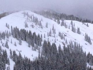
Went for a stroll along PC Ridgeline to look at activity from this storm cycle, and happened to see this slide during a break in the clouds. I'm guessing it occurred during high intensity precip/winds yesterday, but no way to tell for certain. The picture isn't very clear, but crown spans all the way from the looker's left to the looker's right. The slide went over a sub ridge and looked to run to the flats. Estimated width of 500 ft and unknown depth, but I was a long ways away and the crown was very obvious, so I'm guessing depth 2-4+ ft. The upper reaches of Millcreek sees strong Westerly winds, and I suspect this occurred from wind loading. Visibility wasn't good enough to tell if Little Water slid too, but I thought I saw debris on the face. This slide has the same aspect as Little Water and a couple of popular Canyons Ridge runs (Home Run & Sound of Music), so be careful in these areas. Interestingly, no natural activity observed above Desolation Lake and West Desolation Ridge, which both have similar aspects to Sheep Sh!t Ridge -- perhaps not as much wind exposure in these locations?
Coordinates