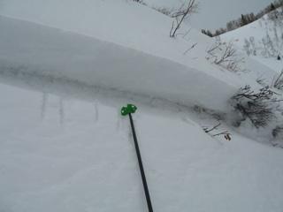
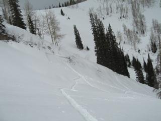
Avalanche appeared to have been human triggered remotely on Sunday March 10th. There was some kind of slope cut near the ridge line moving towards the East facing wall/sub-ridge of the gully on the rider's left side of the main shot in West Willow. It appeared that this slope cut remotely triggered the slide 150 feet down the gully. There was a visible descending crack that ran from the slope cut down the East facing wall of the gully. The crown had aspects ranging from SE to E with almost a right angle at it's apex. The upper SE facing part of the slide had a slope angle of 40 degrees with the descending East facing crown/ridgeline having a slope angle of 45 degrees. The crown was 15 inches deep and appeared to run on the m/f crust developed prior to the new snow that fell on Friday evening. The debris (one finger hardness) piled up against trees up to at least 2.5 feet deep. This was a severe consequence terrain trap the way it ran into two groves of trees and funneled into the right side of the gully. Structural tests in the area on a more Northeasterly facing aspect indicated multiple layers with poor snowpack structure; with the old snow/new snow interface still yielding easy shears one cm above the interface. The slope angle tested was 31 degrees at 9550 feet. Scores were: CT11, SC, Q1 at 11 cm down. This was the weak layer 1 cm above the interface. Other weakness of note in the same pit were scored as follows: CT16, SP, Q2 29 cm down, and ECTP 27, RP, Q2 at 29 cm down. There was also a shear 42 cm down that yielded a CT19, RP, Q2 score.