Forecast for the Uintas Area Mountains

Craig Gordon
Issued by Craig Gordon for
Friday, December 29, 2017

HEADS UP.... AVALANCHE CONDITIONS ARE DECEPTIVELY TRICKY

In upper elevations, at and above treeline, the avalanche danger is CONSIDERABLE. Human triggered avalanches are likely, especially on steep, wind drifted slopes, and particularly on slopes facing the north half of the compass.

MODERATE avalanche danger exists on mid and low elevation shady slopes. Human triggered avalanches are possible on steep slopes with recent deposits of wind drifted snow.

Low elevation south facing slopes and terrain that held no snow prior to the Christmas Eve storm offer generally LOW avalanche danger.

Low
Moderate
Considerable
High
Extreme
Learn how to read the forecast here
Weather and Snow

Skies remained clear overnight and current temperatures are in the mid to upper 20's. West and southwest winds are blowing in the 20's and 30's along the high ridges. No new snow since last weeks holiday, but the Christmas storm was good to the eastern front, delivering close to 2' of much needed snow. Riding and turning conditions are quickly improving, but even with this thick coat of fresh, white paint it's still super thin out there.

Above are 24 hour temperatures and snow depth from Trial Lake along with winds and temperatures from Windy Peak. More remote Uinta weather stations are found here

Recent trip reports and findings can be seen here.

With it's easy access, Wolf Creek Pass is a seamless pre or post work grab. However... just 'cause you can see your rig from the ridge, doesn't mean the snowpack is good to go or shares your same level of stoke.

The graphic above says it all... lean is optimal in some cases, but when it comes to snowpack it leads to dangerous avy conditions.

Recent Avalanches

In late breaking news... a report from Chalk Creek on Tuesday where a rider was completely buried, but rescued by his partners. Details here.


On Wednesday, Ted and I rolled onto this slide on Double Hill just as the dust was settling. Averaging 4' deep and over 700' wide, this avalanche was triggered low on an adjacent slope (lookers left under trees on bottom image), this is the kind of unpredictable avalanche dragon we're dealing with right now. Click HERE for more beta and a short viddy describing what we're seeing on the North Slope. More on this slide and other region-wide reports click here.

On Tuesday, we spotted this remotely triggered slide that's 3' deep x 500' wide on a steep wind drifted slope in Campbell Hollow.


Click HERE for a viddy highlighting Mill Hollow avalanche activity.

HEADS UP- THESE AVALANCHES WERE TRIGGERED REMOTELY, FROM A DISTANCE... WITHOUT EVEN BEING ON THE SLOPE!

Ad
Avalanche Problem #1
Persistent Weak Layer
Type
Location
Likelihood
Size
Description

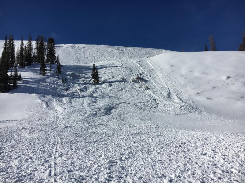
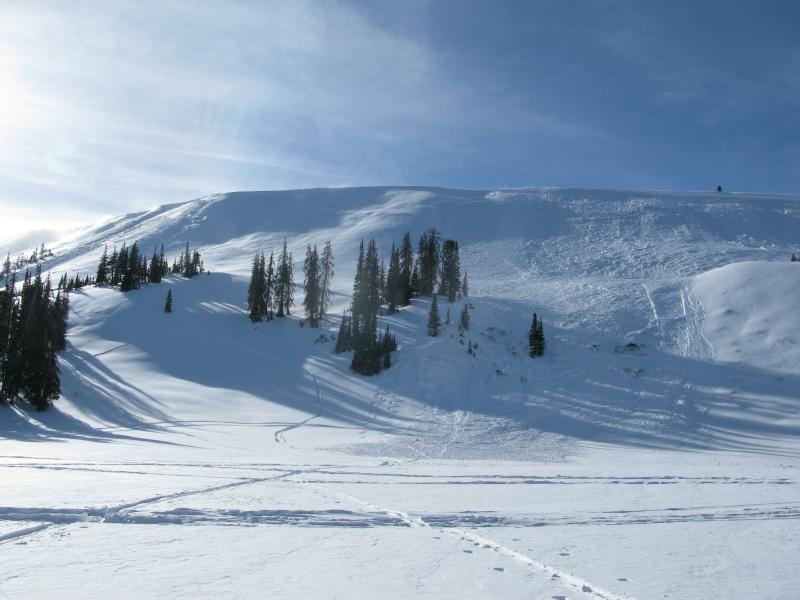
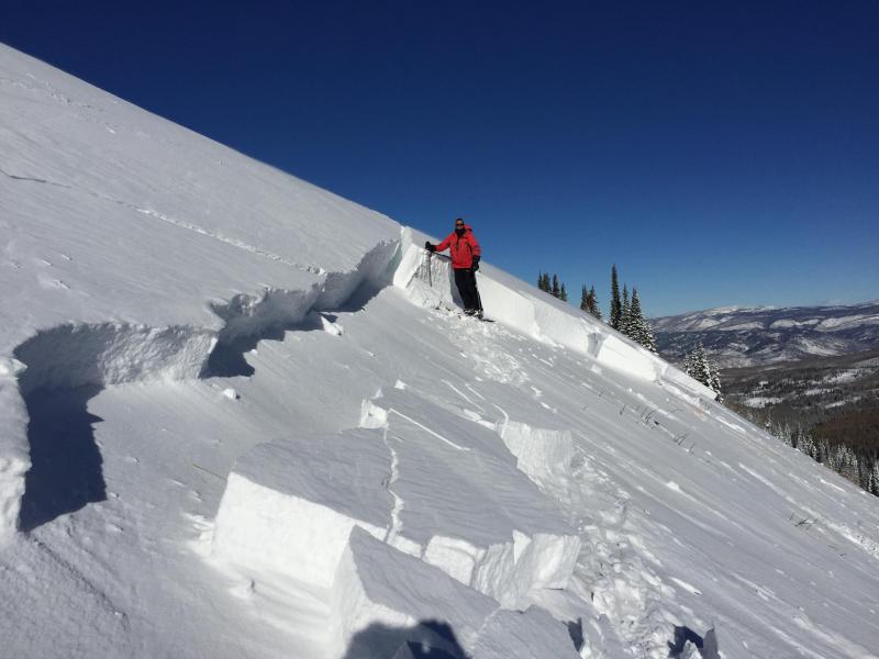
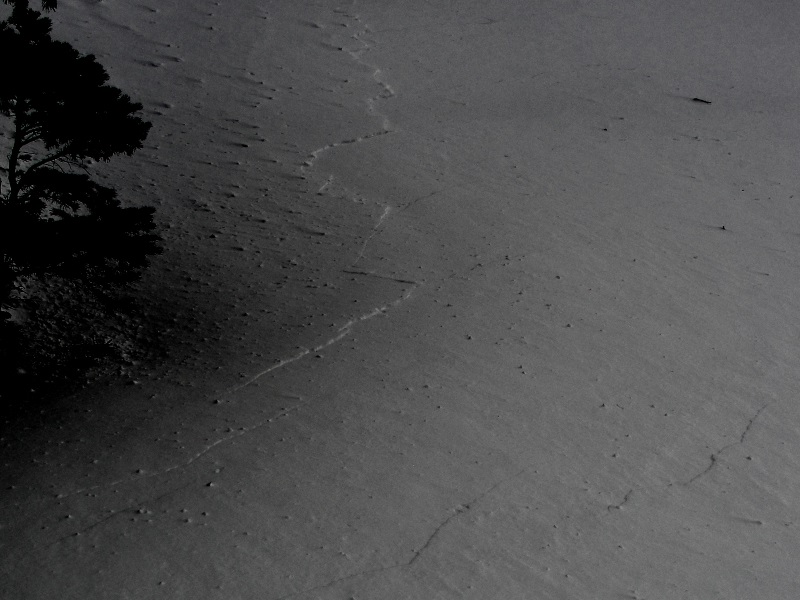
We have an unusual snowpack structure for the western Uinta's right now... it's not our usual weak mess of sugary snow that feels like a sandbox. On the contrary, it's actually comprised of a complex mix of crusts and fragile, sugary facets sandwiched in between. This gives the snowpack some body and allows us to ride without submarining to the ground. All was good and the snowpack comfortable in its own skin until the Christmas storm rolled around and laid down a dense, cohesive slab. So now we have all the ingredients for an avalanche- a slab, a weak layer, and an unusual bed surface. Adding another twist that's out of the ordinary... our bed surface is a raincrust formed on Thanksgiving. That combo is connecting the slab across the slope and the slick bed surface provides little in the way of resistance, allowing avalanches to run much further and faster than you might expect.

So, that's the science behind how we make the sausage. What this means for us is... the snowpack has some strength, but because of its structure (strong snow on weak snow) it offers little in the way of stability. Now I'm no scientist, so I'm gonna rely on the biggest clue to avalanches and that's avalanches. As a matter of fact, recent avalanches and close calls suggest the snowpack remains weak. Now here's the catch... it's tricky because it's not in your face. You don't look around and see widespread natural avalanches everywhere. Right now most slopes just need a trigger like us to come along and knock the legs out from underneath it. All this doesn't mean you can't ride. It does mean we simply need to allow the snowpack to heal and settle out.

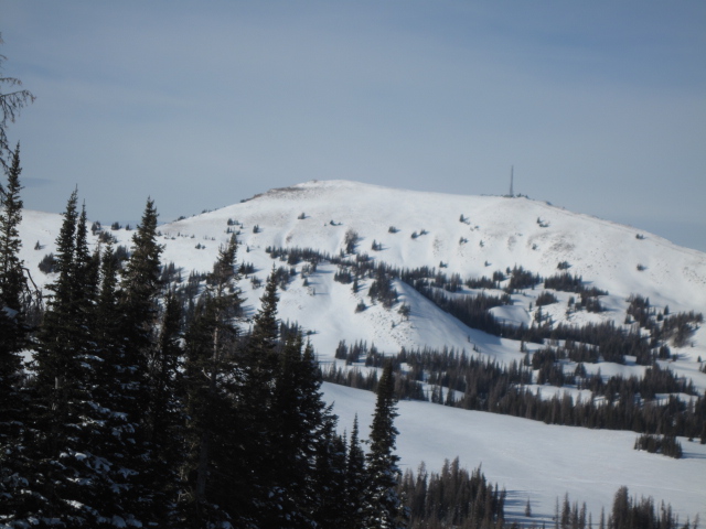
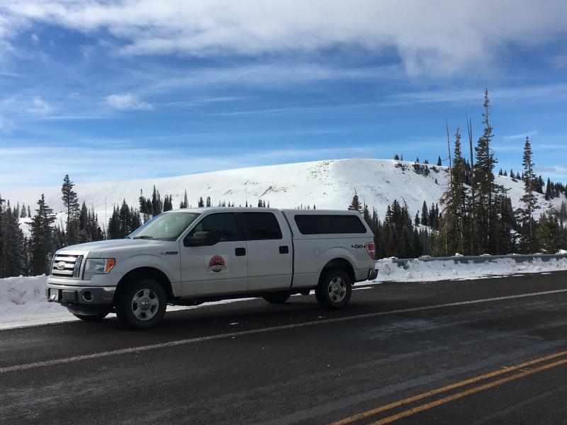
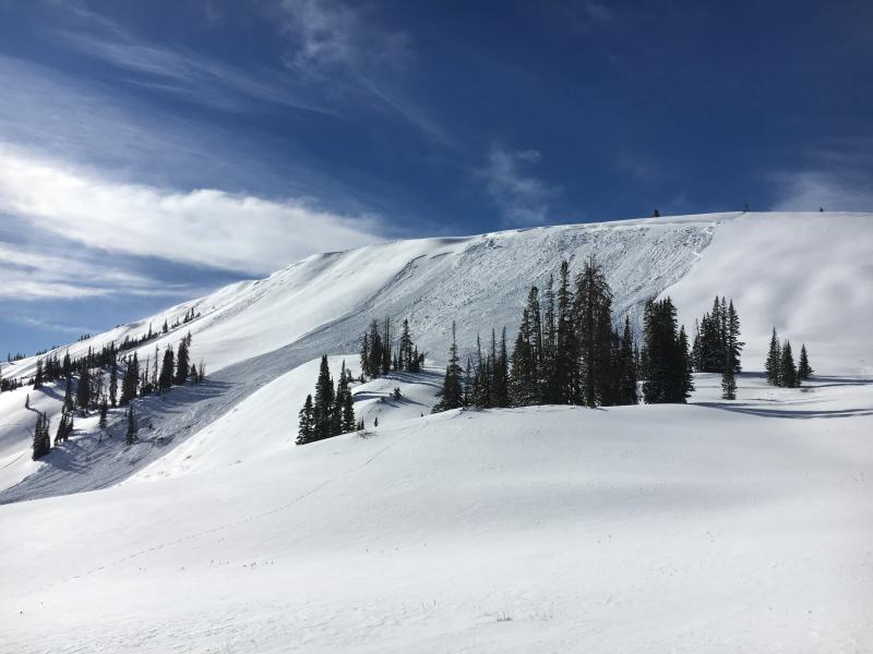
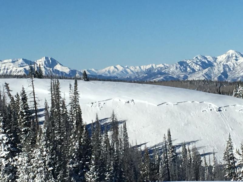
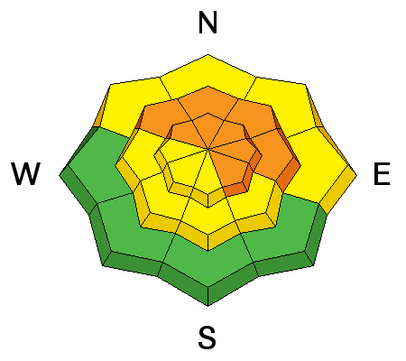
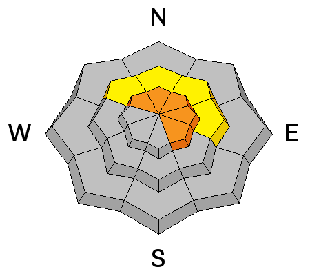
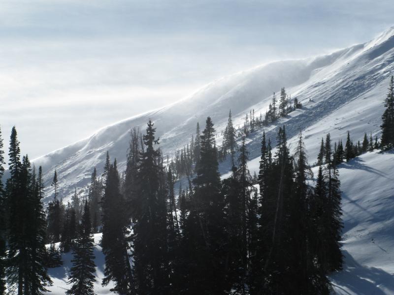
The best strategy is easy... it's avoidance. Simply avoid being on or underneath steep, wind drifted slopes facing the north half fo the compass. Remember- there are plenty of south facing slopes throughout the range, like the one pictured above, where you can ride and you don't even have to deal with this issue.

Avalanche Problem #2
Wind Drifted Snow
Type
Location
Likelihood
Size
Description

West and southwest winds continued blowing into the 40's and 50's for most of yesterday and even though they're running out of fresh snow to work with, they continued whipping up a fresh batch of stiff wind slabs. While found mostly along the leeward side of mid and upper elevation ridges, I wouldn't be too surprised to find sensitive drifts cross-loaded around terrain features like chutes and gully walls. Common theme is... slabs are most prevalent on slopes facing the north half of the compass. Today you'll want to look for and avoid any fat, rounded piece of snow, especially if it sounds hollow like a drum. The snowpack is still relatively thin and the bummer with low tide conditions is, triggering even a small slide greatly increases your chances of slamming into a season ending rock or stump.


Remember- clues to unstable snow include shooting cracks and whoomphing sounds or collapses of the snowpack. (Michael J image)

Additional Information

Today, look for mostly sunny skies and temperatures warming into the 30's. Overnight lows dip into the 20's. West and southwest winds are gonna be annoying, blowing in the 30's and 40's along the high ridges. A weak brush-by on Saturday gives us a few clouds and a flake or two, otherwise not much going on in the weather department through the New Year.

General Announcements

The information in this advisory expires 24 hours after the date and time posted, but will be updated by 7:00 AM Saturday December 30, 2017.

If you're getting out and about, please let me know what you're seeing especially if you see or trigger and avalanche. I can be reached at [email protected] or 801-231-2170

It's also a good time to set up one of our very popular avalanche awareness classes. Reach out to me and I'll make it happen.

This information does not apply to developed ski areas or highways where avalanche control is normally done. This advisory is from the U.S.D.A. Forest Service, which is solely responsible for its content. This advisory describes general avalanche conditions and local variations always occur.