Forecast for the Uintas Area Mountains

Craig Gordon
Issued by Craig Gordon for
Tuesday, December 26, 2017

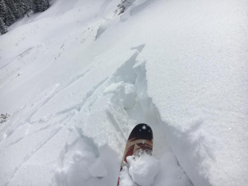
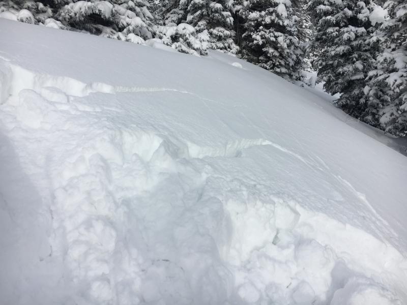
HEADS UP.... IT'S SKETCHY OUT THERE TODAY AND AVALANCHE CONDITIONS ARE DECEPTIVELY TRICKY

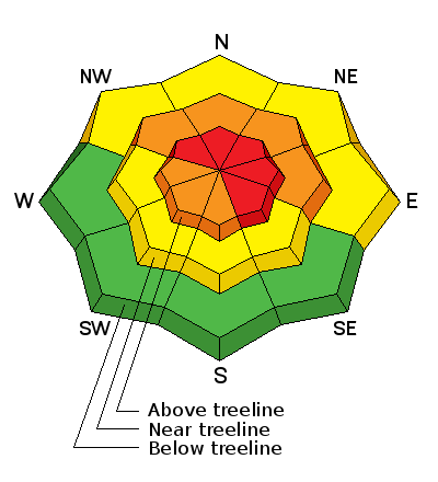
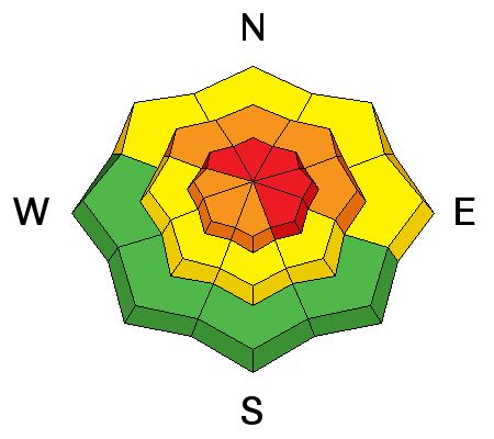
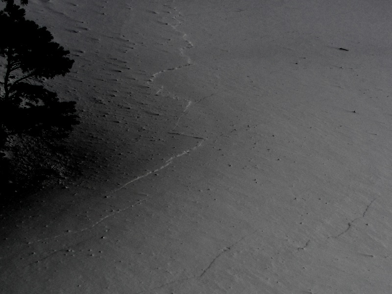
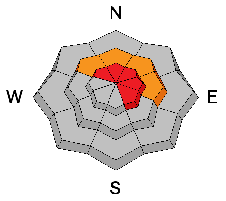
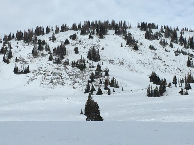
In upper elevations, at and above treeline, the avalanche danger is HIGH. Human triggered avalanches are very likely, especially on steep, wind drifted slopes, and particularly on slopes facing the north half of the compass.

CONSIDERABLE avalanche danger exists on mid elevation terrain and human triggered avalanches are likely on steep slopes with recent deposits of wind drifted snow.

Less widespread and pockety in distribution, a MODERATE avalanche danger is found on wind drifted, low elevation terrain and human triggered avalanches are possible on steep, north facing slopes.

Low elevation south facing slopes and terrain that held no snow prior to the Christmas Eve storm offer generally LOW avalanche danger.

Low
Moderate
Considerable
High
Extreme
Learn how to read the forecast here
Avalanche Warning

* TIMING...IN EFFECT FROM 6 AM MST THIS MORNING TO 6 AM MST WEDNESDAY.

* AFFECTED AREA…FOR THE MOUNTAINS OF NORTHERN UTAH INCLUDING THE BEAR RIVER RANGE, WESTERN UINTAS, AND ALL THE WASATCH RANGE...THE OGDEN, PROVO, SALT LAKE AND PARK CITY AREA MOUNTAINS.

* AVALANCHE DANGER…THE AVALANCHE DANGER FOR THE WARNING AREA IS HIGH TODAY.

* IMPACTS…RECENT SNOW AND WIND HAS CREATED WIDESPREAD AREAS OF UNSTABLE SNOW. HUMAN TRIGGERED AVALANCHES ARE LIKELY.. AVALANCHES CAN BE TRIGGERED REMOTELY FROM A DISTANCE AND FROM BELOW. STAY OFF OF AND OUT FROM UNDER SLOPES STEEPER THAN 30 DEGREES

BACKCOUNTRY TRAVELERS SHOULD CONSULT WWW.UTAHAVALANCHECENTER.ORG OR CALL 1-888-999-4019 FOR MORE DETAILED INFORMATION.

THIS WARNING DOES NOT APPLY TO SKI AREAS WHERE AVALANCHE HAZARD REDUCTION MEASURES ARE PERFORMED.

Weather and Snow

High pressure is building, skies cleared late yesterday, and current temperatures are in the teens. After blowing in the 40's and 50's yesterday, west and southwest winds are backing off into the 30's. No new snow overnight, but the Christmas storm was good to the eastern front, delivering close to 2' of much needed snow. Riding and turning conditions are quickly improving, but even with this thick coat of fresh, white paint it's still super thin out there.

Above are 24 hour temperatures and snow depth from Trial Lake along with winds and temperatures from Lofty Lake Peak. More remote Uinta weather stations are found here

Recent trip reports and findings can be seen here.

With it's easy access, Wolf Creek Pass is a seamless pre or post work grab. However... just 'cause you can see your rig from the ridge, doesn't mean the snowpack is good to go or shares your same level of stoke.

The graphic above says it all... lean is optimal in some cases, but when it comes to snowpack it leads to dangerous avy conditions.

Recent Avalanches

There have been multiple near misses, close calls, and avalanches triggered from a distance in neighboring ranges like the Wasatch and Logan Mountains. Our snowpack is equally as complex and every bit as dangerous.

Sunday, I visited my "go to" test slope on the south half of the range and it definitely let me know the snowpack needs more time to adjust to the Christmas storm cycle. As I approached this 36 degree north facing slope, it collapsed and cracks shot out in front of my skis. Click here for a little viddy describing what's going on with the pack.

Ad
Avalanche Problem #1
Wind Drifted Snow
Type
Location
Likelihood
Size
Description

West and southwest winds continued blowing into the 40's and 50's for most of Christmas Day. With plenty of fresh snow to work with, they' whipped up a fresh batch of stiff wind slabs. While found mostly along the leeward side of mid and upper elevation ridges, I wouldn't be too surprised to find sensitive drifts cross-loaded around terrain features like chutes and gully walls. Common theme is... slabs are most prevelent on slopes facing the north half of the compass. Today you'll want to look for and avoid any fat, rounded piece of snow, especially if it sounds hollow like a drum. Remember- clues to unstable snow include shooting cracks and whoomphing sounds or collapses of the snowpack. The snowpack is still relatively thin and the bummer with low tide conditions is, triggering even a small slide greatly increases your chances of slamming into a season ending rock or stump.

Michael J was near the Duke Bowl Sunday and he too experienced widespread collapsing and whoomphing of the snowpack.

Avalanche Problem #2
Persistent Weak Layer
Type
Location
Likelihood
Size
Description

Here's where it gets tricky. We've got a complex snowpack with a myriad of crusts and weak, sugary snow sandwiched in between. Yes, we've got a deceptively tricky snowpack. As a matter of fact, this layering is the kind of combination when I see the vast majority of close calls and near misses in the western Uinta's.

Before the Christmas Eve storm, we got nickled, dimed, and teased with bits and pieces of little storms and there wasn't enough weight to activate any of the buried weak layers. However, with the recent round of snow and wind I think we've hit a critical crossroads and our complex snowpack is teetering on the edge. As a matter of fact, I bet It won't take much to kick the legs out from under the slab and I think you can initiate a slide from a distance or low on the slope. Once triggered, an avalanche could quickly get of hand as it breaks to weaker snow near the ground.

The best strategy is easy... it's avoidance. Simply avoid being on or underneath steep, wind drifted slopes facing the north half fo the compass. Remember- there are plenty of south facing slopes you can ride throughout the range where you don't even have to deal with this issue.

Click here for a short viddy describing the setup.

Here's your exit strategy for today. South facing terrain that had little or no old weak snow prior to the Christmas Eve storm.

Additional Information

It'll be a sunny day with temperatures warming into the upper 20's and low 30's. Westerly winds will generally blow in the 20's and 30's, though along the highest peaks we may see an occasional gust into the 50's or 60's. Not much going on in the weather department this week and there are no significant storms in our future.

General Announcements

The information in this advisory expires 24 hours after the date and time posted, but will be updated by 7:00 AM Wednesday December 27, 2017.

If you're getting out and about, please let me know what you're seeing especially if you see or trigger and avalanche. I can be reached at [email protected] or 801-231-2170

It's also a good time to set up one of our very popular avalanche awareness classes. Reach out to me and I'll make it happen.

This information does not apply to developed ski areas or highways where avalanche control is normally done. This advisory is from the U.S.D.A. Forest Service, which is solely responsible for its content. This advisory describes general avalanche conditions and local variations always occur.