Forecast for the Uintas Area Mountains

Craig Gordon
Issued by Craig Gordon for
Monday, November 28, 2016

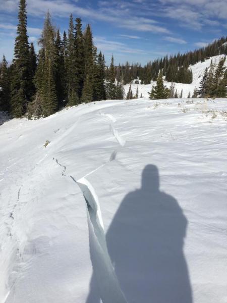
The avalanche danger will be on the rise as the storm develops.

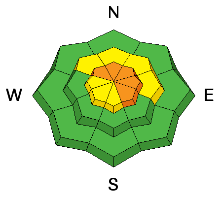
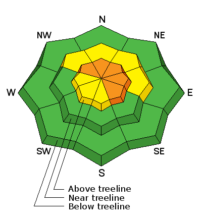
In the wind zone, at and above treeline, the avalanche danger is CONSIDERABLE this morning. Human triggered avalanches are likely and natural avalanches possible, especially on steep, wind drifted, shady slopes facing the north half of the compass. As the storm develops and winds continue to rage, expect the avalanche danger to rise to HIGH by days end.

At mid elevations you'll find MODERATE avalanche danger and human triggered avalanches are possible on steep slopes with recent deposits of wind drifted snow.

Out of the wind and in low elevation terrain the avalanche danger is generally LOW.

Low
Moderate
Considerable
High
Extreme
Learn how to read the forecast here
Special Avalanche Bulletin

THE FOREST SERVICE UTAH AVALANCHE CENTER IN SALT LAKE CITY HAS ISSUED A SPECIAL AVALANCHE BULLETIN

* TIMING…IN EFFECT FROM 6AM MST THIS MORNING TO 6 AM MST TUESDAY

* AFFECTED AREA…FOR THE MOUNTAINS OF NORTHERN UTAH INCLUDING THE WASATCH RANGE...UINTA MOUNTAINS.

* AVALANCHE DANGER…THE AVALANCHE DANGER IS EXPECTED TO RISE TO HIGH

* IMPACTS... EXPECTED HEAVY SNOWFALL AND STRONG WINDS WILL CREATE WIDESPREAD AREAS OF UNSTABLE SNOW. BOTH HUMAN TRIGGERED AND NATURAL AVALANCHES WILL BE LIKELY. STAY OFF OF AND OUT FROM UNDER SLOPES STEEPER THAN 30 DEGREES.

THIS WATCH DOES NOT APPLY TO OPERATING SKI AREAS WHERE AVALANCHE HAZARD REDUCTION MEASURES ARE PERFORMED.

Special Announcements

The headline news is... increasing avalanche danger during the day. Click here to view an updated synopsis from our partners at the National Weather Service detailing the storms headed our way.

Heads up- both Wolf Creek Pass and Mirror Lake Highway are still passable and access to avalanche terrain is relatively easy. Remember... just cause you can see your rig from a ridgeline doesn't necessarily make the terrain any safer and triggering even a small slide this time of year will reveal stumps, rocks, and general nastiness, easily ruining your day or perhaps your season.

Weather and Snow

Storm totals are becoming more uniform across the range with 10" stacking up in the past 24 hours. Westerly winds have been getting after it, averaging in the 30's and 40's with a few gusts into the 50's along the high peaks. Under mostly cloudy skies and a scattered snow flurry or two, it'll feel like winter this morning with temperatures currently registering in the mid teens. Total snow depths are in the 18"-24" range and while it's still pretty thin out there, this latest round of snow is going to make travel a bit easier.

Real time wind, snow, and temperatures for the Uinta's are found here.


It's starting to fill in, but you gotta think light. Meadow skipping is still your best bet. Ted was in Whitney Basin Saturday and as usual, has a great assessment of the conditions found here. Ted Scroggin photo.

Recent Avalanches

No new avalanche activity to report.

Ad
Avalanche Problem #1
Persistent Weak Layer
Type
Location
Likelihood
Size
Description

It's a day of rising avalanche danger. Until now, avalanche conditions have been pretty straight-forward and rather benign because of the obvious... we were lacking a snowpack! Well that's all changed in the past 24 hours, because now we've got an actual snowpack to talk about along with some layering and a bit of structure. Sounds like avalanche forecaster speak, but what this means is... it's about to get tricky. With strong winds ripping along the ridges for the past 24 hours and an abundance of fresh snow to work with, dense, cohesive slabs or wind drifts have formed along on the leeward side of mid and upper elevation ridges, especially slopes facing the north half of the compass. Today's slabs are going to be reactive to the additional weight of a person and have the possibility to break deeper and wider than you might expect. If your travels take you into upper elevation terrain, you'll want to look for and avoid any fat looking piece of snow, especially if it feels or sounds hollow like a drum.

Shooting cracks like this, collapsing, or loud whoomphing sounds are natures big red flags. Weston was in Upper Weber Canyon when he snapped this image Saturday. More on his travels here. Weston Deutschlander​ photo.

Additional Information

Snow begins to stacking up in earnest this morning as a cold, moist storm starts to take shape over the region. Snow totals by Tuesday morning should be near a foot. Westerly winds will crank into the 30's and 40's with gusts near 60 mph along high ridges, before turning more northwesterly and diminishing late in the day. Expect cold temperatures with highs in the upper teens and low 20's and overnight lows in the single digits. A break in the action is slated for Tuesday and Wednesday with another small shot of snow Thursday.

General Announcements

Remember your information can save lives. If you see anything we should know about, please participate in the creation of our own community avalanche advisory by submitting snow and avalanche conditions. You can call me directly at 801-231-2170, email [email protected]

The information in this advisory is from the US Forest Service which is solely responsible for its content. This advisory describes general avalanche conditions and local variations always occur.

The information in this advisory expires 24 hours after the date and time posted, but will be updated on Tuesday November 29th.