Forecast for the Uintas Area Mountains

Craig Gordon
Issued by Craig Gordon for
Friday, November 27, 2015

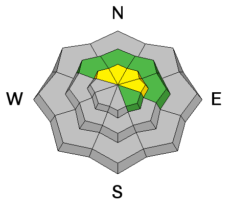
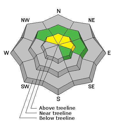
In general most terrain throughout the range offers a LOW avalanche danger.

However, at and above treeline, the avalanche danger is MODERATE. While pockety at best, human triggered avalanches are possible, on steep, wind drifted slopes facing the north half of the compass.

Low
Moderate
Considerable
High
Extreme
Learn how to read the forecast here
Weather and Snow

Scattered snow showers yesterday delivered another inch or so of very light density snow and the range is looking a bit more like winter, however it's still pretty shallow out there and riding options are limited to road rides or low angle grassy meadows. This morning skies are partly cloudy, southeast winds are blowing 10-20 mph along the high peaks, and temperatures are near zero. Factor in a little wind chill and it's -15 degrees along the ridges.

Our western Uinta weather station network is up and running. Click here for real time snow,winds, and temperatures.

Recent trip reports and observations are found here.

Recent Avalanches

No recent avalanche activity to report, but we are posting observations from the backcountry on a daily basis now. See or trigger an avalanche? Shooting cracks? Hear a collapse? It's simple. Go here to fill out an observation.

Ad
Avalanche Problem #1
Wind Drifted Snow
Type
Location
Likelihood
Size
Description

The wind drifts I was concerned about yesterday were pretty well-behaved and it appears the snowpack has adjusted to the Thanksgiving storm. In general, the avalanche danger is Low, but of course, the Uinta's are a big range and I bet there's an old wind slab or two out there that may still be sensitive to the additional weight of a rider. The most likely suspect is gonna be steep, wind drifted, upper elevation slopes, especially those facing the north half of the compass. Remember- it's still really thin out there and even a shallow slide can take you for a nasty ride through rocks and stumps barely hidden under our shallow snowpack.

Additional Information

A break in the weather is expected for this morning before clouds and scattered snow showers return this afternoon and linger into Saturday. Temperatures climb into the low 20's and then dive into the single digits overnight. East and southeast may bump into the 20's along the high ridges during the day. We remain in an unsettled pattern through the weekend with on-again, off-again snow showers, before skies clear out and a warming trend develops early in the week.

General Announcements

Remember your information can save lives. If you see anything we should know about, please participate in the creation of our own community avalanche advisory by submitting snow and avalanche conditions. You can call me directly at 801-231-2170, email [email protected], or email by clicking HERE

This is a great time of year to schedule a free avalanche awareness presentation for your group or club. You can contact me at 801-231-2170 or email [email protected]. To register for the first in our series of on-the-snow sled specific classes you can register here.

The information in this advisory is from the US Forest Service which is solely responsible for its content. This advisory describes general avalanche conditions and local variations always occur.

The information in this advisory expires 24 hours after the date and time posted, but be will be updated by 7:00 AM on Saturday November 28th.