Forecast for the Skyline Area Mountains

Brett Kobernik
Issued by Brett Kobernik for
Thursday, November 26, 2015

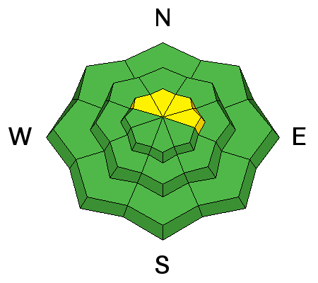
The majority of the terrain has a LOW avalanche danger today. There is a MODERATE avalanche danger along the ridgetops where spotty wind slabs might release under the weight of a person. Watch for any cracking when you are in the upper elevations which would indicate there may be fresh sensitive drifts present.
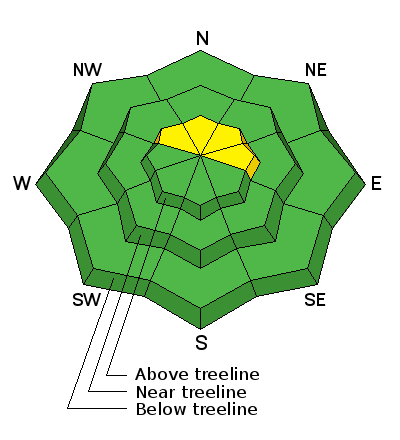
Low
Moderate
Considerable
High
Extreme
Learn how to read the forecast here
Weather and Snow

A cold front passed late afternoon on Wednesday and left the Skyline with a nice little shot of snow. It appears the the northern end near Fairview Canyon did better than the terrain farther south. The Mammoth Cottonwood Snotel bumped up from 10 to 17 inches of total snow on the ground. Stations up Ephraim Canyon only bumped up about 4 inches. Southwest winds were fairly strong during the snow event but have really tapered off in speed overnight. Temperatures dropped into the mid to low teens below 10,000'. Higher stations are in the single digits.

Recent Avalanches

Our snowpack throughout the Skyline has deteriorated with many areas now holding copious amounts of faceted snow. This is not a huge concern at this time but it is something that we really need to pay attention to when more storms roll through. This faceted snow has the potential to act as a persistent weak layer once it gets buried.

Ad
Avalanche Problem #1
Wind Drifted Snow
Type
Location
Likelihood
Size
Description

The new snow coupled with some wind may have created a few new drifts as well. For most folks out today, this won't present much problem. If you are monkeying around in steep terrain along the higher ridges, this is the place you might find problems. Buried facets may act as a weak layer under some of these drifts making them a little harder to assess.

Additional Information

We'll see partly to mostly cloudy skies today with a slight chance of snow showers. Light snowfall is more likely later in the afternoon. High temps today should get into the upper teens to low 20s. Winds look like they should be fairly light with variable directions.

General Announcements

We are currently publishing avalanche advisories as needed which is mostly related to new snow storms.

If you are getting out into the mountains, we love to hear from you! You can SUBMIT OBSERVATIONS ONLINE or EMAIL US

If you would like to have avalanche advisories emailed to you, SIGN UP HERE

We can provide basic avalanche awareness presentations for your school, group or club. To enquire, CLICK HERE