Forecast for the Salt Lake Area Mountains

Wednesday, December 7, 2016
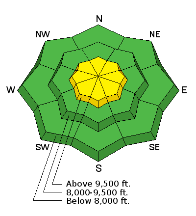
The avalanche danger is MODERATE at upper elevations where you are more likely to find wind slabs and wind drifted snow. At low and mid elevations the avalanche danger is LOW.


The avalanche danger is MODERATE at upper elevations where you are more likely to find wind slabs and wind drifted snow. At low and mid elevations the avalanche danger is LOW.

The Park City Ski Patrol will be doing avalanche mitigation work in the Jupiter area for the remainder of the week. Please avoid this area.
Please read and share with others: New Avalanche Explosives Work Backcountry Closure Procedures Going Into Effect.
Temperatures are in the single digits F this morning with winds blowing 5-15 mph from the WNW and gusting to 20-30 mph. Yesterday evening winds near 11,000 feet increased and blew 40 mph from the W gusting to 60-70 mph. They have eased this morning. Since yesterday 1-2 inches of very light snow accumulated with lake effect producing a bit more light snow this morning. Cold temperatures combined with a few inches of new snow will make great skiing and riding conditions on slopes sheltered from wind.
Looking forward: Cold temperatures facet and weaken the snowpack especially in areas with thin snow cover. Temperatures at the ground are near 32 degrees F and much colder at the snow surface. Areas with thin snow cover have this temperature difference over a short distance. This temperature difference over a short distance creates a large temperature gradient which causes faceting and weakening of the snow. Read more about this process HERE.
What does this mean? If we get a big load of snow from the next storm, areas with thin snow may not be able to support the load and will produce avalanches. Of course "thin" is a relative term and it depends on what the temperature difference is. Finding loose, sugary snow indicates the presence of weak facets. We'll be hunting for areas of weak snow in coming days.
No avalanches were reported yesterday. Fresh winds slabs were triggered at ski areas on Monday including one along the Park City Ridgeline that was 100 feet wide.

Wind slabs continue to be the main avalanche problem to look for and avoid. The main red flag for today is that very strong, westerly winds blew near 11,000 feet yesterday evening. These winds likely formed fresh wind slabs that can be triggered today. The good news is that many slopes at lower elevations have been untouched by winds and have stable conditions.
An additional concern: triggering a wind slab on northerly aspects could cause a larger avalanche to break on weak facets at the ground. This faceted layer exists in isolated locations, mainly high elevation, northerly aspects that held the most snow in early November.
Light snowfall this morning will end and skies will clear today. Winds will ease and blow from the NW at 5-10 mph. Despite sunny skies this afternoon, temperatures will struggle to break out of the single digits F. A significant storm should arrive tomorrow afternoon and produce snowfall through Saturday. Total water amounts by Saturday morning could be over 2 inches which correlate to over 2 feet of snow. Higher amounts are definitely possible. Another storm may arrive Sunday night.
The image below shows total precipitation in term of water amounts by 0800 Saturday morning.
Remember your information can save lives. If you see anything we should know about, please help us out by submitting snow and avalanche conditions. You can also call us at 801-524-5304, email by clicking HERE, or include #utavy in your tweet or Instagram.
To get help in an emergency (to request a rescue) in the Wasatch, call 911. Be prepared to give your GPS coordinates or the run name. Dispatchers have a copy of the Wasatch Backcountry Ski map.
Backcountry Emergencies. It outlines your step-by-step method in the event of a winter backcountry incident.
If you trigger an avalanche in the backcountry, but no one is hurt and you do not need assistance, please notify the nearest ski area dispatch to avoid a needless response by rescue teams. Thanks.
EMAIL ADVISORY If you would like to get the daily advisory by email you will need to subscribe here.
DAWN PATROL Hotline updated daily by 5-530am - 888-999-4019 option 8.
TWITTER Updates for your mobile phone - DETAILS
UDOT canyon closures: LINK TO UDOT, or on Twitter, follow @UDOTavy, @CanyonAlerts or @AltaCentral
Utah Avalanche Center mobile app - Get your advisory on your iPhone along with great navigation and rescue tools.
Powderbird Helicopter Skiing - Blog/itinerary for the day
Lost or Found something in the backcountry? - http://nolofo.com/
To those skinning uphill at resorts: it is critical to know the resort policy on uphill travel. You can see the uphill travel policy for each resort here.
Benefit the Utah Avalanche Center when you shop from Backcountry.com or REI: Click this link for Backcountry.com or this link to REI, shop, and they will donate a percent of your purchase price to the UAC. Both offer free shipping (with some conditions) so this costs you nothing!
Benefit the Utah Avalanche Center when you buy or sell on ebay - set the Utah Avalanche Center as a favorite non-profit in your ebay account here and click on ebay gives when you buy or sell. You can choose to have your seller fees donated to the UAC, which doesn't cost you a penny.
 This information does not apply to developed ski areas or highways where avalanche control is normally done. This advisory is from the U.S.D.A. Forest Service, which is solely responsible for its content. This advisory describes general avalanche conditions and local variations always exist.