Forecast for the Salt Lake Area Mountains

Evelyn Lees
Issued by Evelyn Lees for
Wednesday, December 20, 2017

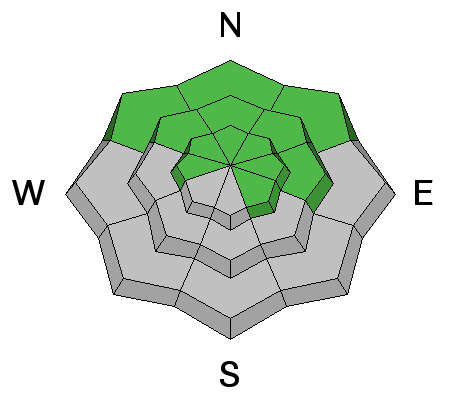
It is a day of rising avalanche danger as the wind drifts (wind slabs) grow. The avalanche danger is MODERATE today - human triggered wind slab avalanches are possible on mid and upper elevation slopes facing northwest through southeast, where the snow drifts are sitting on old snow. Evaluate snow and terrain carefully, identify and avoid all wind drifts on steep slopes. The avalanche danger will increase and become more widespread when the snow arrives late this afternoon.

Out of the wind-affected terrain, loose snow sluffs and shallow soft slabs may be triggered tonight if we get more than about 6” to 9” of snow.

Low
Moderate
Considerable
High
Extreme
Learn how to read the forecast here
Special Announcements

Don’t know what to buy your favorite skier for Christmas? Discount lift tickets for Alta, Snowbird, Brighton, Solitude, Deer Valley, Snowbasin,and Beaver Mountain are now available, donated by the resorts to benefit the Utah Avalanche Center. Details and order information here. These make a great holiday gift and all proceeds go towards paying for avalanche forecasting and education!

Weather and Snow

The southwesterly winds picked significantly a few hours before midnight – and at 10,000’ are averaging 15 to 20 mph, gusting in the 30s. Winds are racing across the highest elevation ridgelines, averaging in the 40s, gusting in the 50s and 60s. Temperatures have warmed into the upper 30s at mid elevations.

Total snow on the shady, mid and upper elevation slopes is around 1 to 2 feet, and unsupportable in shallower snowpack areas. Sunny slopes are a mix of crusty snow and bare ground.

View the latest observations here.

Recent Avalanches

No new avalanche activity has been reported.

Ad
Avalanche Problem #1
Wind Drifted Snow
Type
Location
Likelihood
Size
Description

The wind is changing the landscape and avalanche danger today. Even before the storm and new snow arrives, the winds will be drifting old snow, and these small drifts will be crossloaded onto a variety of aspects and elevations. Key points:

  • The most dangerous drifts will be those on northwest through southeasterly facing slopes, where they are landing on old weak, faceted snow.
  • The drifts are both along the ridges and well off the ridgelines, mid slope.
  • You will be able to trigger these shallow drifts from a distance, or worse, from below.
  • Avoid travel on and below steep wind drifted slopes - cracking, collapsing or harder, dense snow are signs of a wind drift.
  • Danger will increase late today and overnight as the storm arrives and we receive snow.
  • Out of the wind-affected terrain, you may be able to trigger loose snow sluffs this evening or tonight in the new snow.
  • Due to lack of snow, being caught and carried by even a small avalanche could be very dangerous, as you will be dragged through shallowly buried rocks or downed trees.
Avalanche Problem #2
Persistent Weak Layer
Type
Location
Likelihood
Size
Description

After 3 weeks of high pressure, very weak faceted snow exists across the northern Utah mountains, wherever there was snow on the ground before this storm. The snowpack on the shady slopes consists of weak crusts and sugary faceted snow. Once we get some weight on these weak layers, dangerous avalanches could be triggered. We are watching this storm carefully to see if we over load these layers this evening or tonight. Right now, the storm is looking too small.

Additional Information

Another case of incredible shrinking snow numbers – the hope now is for 4 to 9” of low-density snow by tomorrow morning. For today, moderate to strong, southwesterly winds until the afternoon frontal passage, with high temperatures at 9,500’ in the mid to upper 30s. Frontal passage is forecast for 3 to 5 pm, accompanied by a burst of heavy snow. Wind will shift to the northwest, and decrease after a few hours, and temperatures drop, into the single digits by morning. A few lingering snow showers are possible Thursday morning, with highs only in the teens and 20s, under a brisk, northeasterly flow.

General Announcements

FOR MORE GENERAL INFORMATION CLICK HERE

Benefit the Utah Avalanche Center when you buy or sell on ebay - set the Utah Avalanche Center as a favorite non-profit in your ebay account here and click on ebay gives when you buy or sell. You can choose to have your seller fees donated to the UAC, which doesn't cost you a penny.

This information does not apply to developed ski areas or highways where avalanche control is normally done. This advisory is from the U.S.D.A. Forest Service, which is solely responsible for its content. This advisory describes general avalanche conditions and local variations always occur.