Forecast for the Provo Area Mountains

Evelyn Lees
Issued by Evelyn Lees for
Tuesday, December 26, 2017

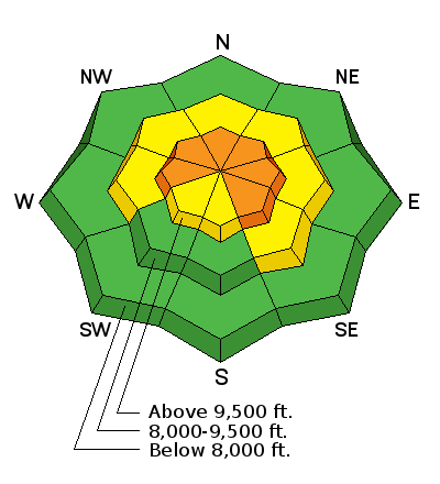
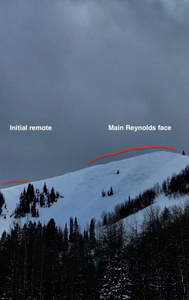
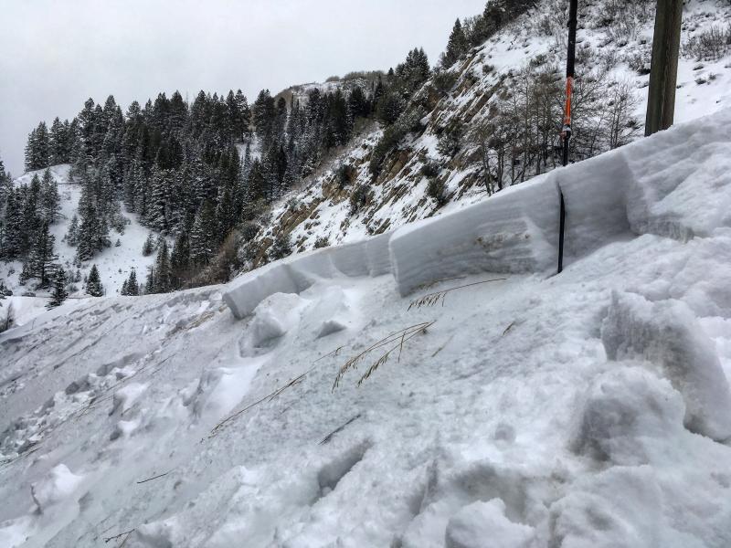
AVALANCHE WARNING - The avalanche danger is CONSIDERABLE today – backcountry travel in avalanche terrain is not recommended. The danger is HIGH and more widespread in the Western Uinta mountains and the mountains to the north of the Provo area mountains. Human triggered avalanches are likely on steep slopes facing northwest through easterly at the upper elevations in the Provo area mountains. Avalanches can be triggered remotely from a distance and from below. Avoid travel on and below all steep slopes, both the large obvious avalanche paths and smaller, steep gullies, creek beds and road banks at the lower elevations.

Avoid avalanche terrain by heading to slopes less steep about 30 degrees, which are not adjacent to or below steeper terrain, such as meadows and rolling, low angle terrain.

Low
Moderate
Considerable
High
Extreme
Learn how to read the forecast here
Avalanche Warning

THE FOREST SERVICE UTAH AVALANCHE CENTER IN SALT LAKE CITY HAS CONTINUED THE BACKCOUNTRY AVALANCHE WARNING.

* TIMING…IN EFFECT FROM 6 AM MST THIS MORNING TO 6 AM MST WEDNESDAY MORNING

* AFFECTED AREA…FOR THE MOUNTAINS OF NORTHERN UTAH INCLUDING THE BEAR RIVER RANGE, WESTERN UINTAS, AND ALL THE WASATCH RANGE...THE OGDEN, PROVO, SALT LAKE AND PARK CITY AREA MOUNTAINS.

* AVALANCHE DANGER…THE AVALANCHE DANGER FOR THE WARNING AREA IS HIGH TODAY.

* IMPACTS…RECENT SNOW AND WIND HAS CREATED WIDESPREAD AREAS OF UNSTABLE SNOW. HUMAN TRIGGERED AVALANCHES ARE LIKELY. STAY OFF OF AND OUT FROM UNDER SLOPES STEEPER THAN 30 DEGREES. AVALANCHES CAN BE TRIGGERED REMOTELY FROM A DISTANCE AND FROM BELOW.

THIS WARNING DOES NOT APPLY TO SKI AREAS WHERE AVALANCHE HAZARD REDUCTION MEASURES ARE PERFORMED.

Special Announcements

Do you have all the gear you need? Check out the UAC’s online marketplace and auction for deals on resort passes, skis, packs, airbag packs, beacons, snowshoes, soft goods and much more. The auction closes at 6PM on December 28.

Weather and Snow

Winter is trying to arrive - since December 22 the Provo area mountains have received over a foot of snow, with probably closer to 1 1/2 feet up high.

Under partly cloudy skies, temperatures are in the teens to mid 20s this morning. Winds are from a westerly direction, averaging 5 to10 mph at the mid elevations, with average speeds up to 20 mph at the higher elevations.

Recent Avalanches

No new avalanche activity has been reported from the Provo area mountains.

But...if you are heading to the Cottonwoods or Park City side, take note:

Yesterday, backcountry avalanche activity included slides triggered remotely from a distance on Reynolds Peak and a large slide triggered from below in Porter Fork. These broke on layers of weak, sugary faceted snow. Avalanche reduction work at the Cottonwood resorts resulted in many large avalanches from both explosives and ski cuts, some breaking mid-pack or to the ground. Many were running long distances and some of these were large enough to break a few trees. All elevations on the northerly facing slopes were active, including elevations below 9000 ft. Click HERE for recent Salt Lake and Park City area mountain observations.

Upper photo: Reynolds Peak, Drew Hardesty photo

Ad
Avalanche Problem #1
Persistent Weak Layer
Type
Location
Likelihood
Size
Description

Collapsing, cracking and avalanches. These are the bulls eye clues to watch for in the upper elevations of the Provo area mountains. These weak faceted layers will be very slow to stabilize, and avoidance is key. The facets are most widespread on northwest through easterly facing slopes at the upper elevations. So avoid travel on and below all steep slopes, including even the smaller, steep gullies, creek beds and road banks at the mid elevations.

Mark White photo from 12/24 of a creek band slide at 7,200' - an example of a terrain trap.

Avalanche Problem #2
Wind Drifted Snow
Type
Location
Likelihood
Size
Description

While more stubborn, wind drifts could still be triggered on steep slopes today – most widespread along or just off ridgelines. Once any snow gets moving, it could step down to one of the deeper weak layers, resulting in a much larger avalanche.

Additional Information

We will be under a dry and mild west to northwest flow through the end of the week. Today, skies will be partly cloudy to sunny. Temperatures will be warm – reaching into the twenties to mid 30s today. Winds will mostly be light, in the 10 to 20 mph range, though the 11,000’ winds may gust into the 50 to 60 mph range at times.

General Announcements

FOR MORE GENERAL INFORMATION AND FAQ, CLICK HERE

Support the UAC through your daily shopping. When you shop at Smith's, or online at REI, Backcountry.com, Patagonia, NRS, Amazon, eBay a portion of your purchase will be donated to the FUAC. See our Donate Page for more details on how you can support the UAC when you shop.

Benefit the Utah Avalanche Center when you buy or sell on eBay - set the Utah Avalanche Center as a favorite non-profit in your eBay account here and click on eBay gives when you buy or sell. You can choose to have your seller fees donated to the UAC, which doesn't cost you a penny

This information does not apply to developed ski areas or highways where avalanche control is normally done. This advisory is from the U.S.D.A. Forest Service, which is solely responsible for its content. This advisory describes general avalanche conditions and local variations always occur.