Forecast for the Ogden Area Mountains

Drew Hardesty
Issued by Drew Hardesty for
Monday, December 4, 2017

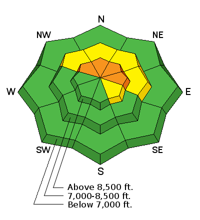
Areas of CONSIDERABLE danger exists in steep terrain this morning. Wind drifts and loose snow avalanches should be expected in all steep terrain holding previous snow (upper elevation northwest through northeast facing slopes). Shooting cracks and audible collapsing of the snowpack are immediate signs of potential avalanche danger.

Hot Tip: the best conditions will also be the safest: lower angle non-drifted terrain will be 5 star with the cold smoke on the underlying crusts.

Low
Moderate
Considerable
High
Extreme
Learn how to read the forecast here
Special Announcements
Weather and Snow

A good old fashioned cold front rolled through yesterday afternoon and we're up to 8-10" in the mountains and 6-8" at the trailheads. Temps are in the teens. Winds have calmed significantly from yesterday and are blowing from the west northwest at 10-15mph with gusts to 25.

Recent Avalanches

There has been no reported recent avalanche activity in the Ogden area mountains.

Ad
Avalanche Problem #1
New Snow
Type
Location
Likelihood
Size
Description

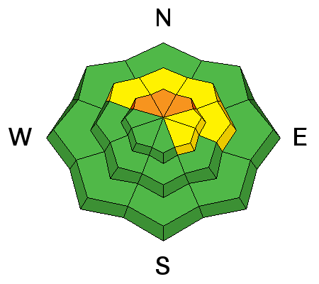
The low density snow should be quite reactive this morning, running naturally and with human provocation in steep terrain that harbored previously existing snow. Expect the sluffs to run fast and far in steep sustained terrain. For more info on loose snow avalanches, click the 'i' next to the info-graphic above.

Avalanche Problem #2
Wind Drifted Snow
Type
Location
Likelihood
Size
Description

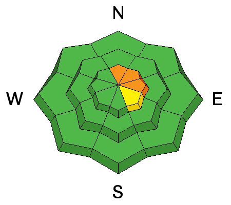
Soft but sensitive wind drifts up to 18" are likely in upper elevation wind drifted terrain. Drifts in the low density snow will also be cross-loaded beyond sub-ridges and into gullies and to the lee of other terrain features. Watch for cracking and spider-webbing of the snow for immediate clues to instability.

Additional Information

Get it while you can. We may be able to squeeze another inch or two before it moves off to the east. Winds as well should start to calm down and blow 15mph from the northwest. Temps will be in the upper single digits along the high ridgelines and the teens at the trailheads. What has been already billed as a "monster ridge" starts to build in tomorrow for the foreseeable future.

General Announcements

Remember your information can save lives. If you see anything we should know about, please help us out by submitting snow and avalanche conditions. You can also call us at 801-524-5304, email by clicking HERE, or include #utavy in your tweet or Instagram.

To get help in an emergency (to request a rescue) in the Wasatch, call 911.

If you trigger an avalanche in the backcountry, but no one is hurt and you do not need assistance, please notify the nearest ski area dispatch to avoid a needless response by rescue teams. Thanks.

Utah Avalanche Center mobile app - Get your advisory on your iPhone along with great navigation and rescue tools.

To those skinning uphill at resorts: it is critical to know the resort policy on uphill travel. You can see the uphill travel policy for each resort here.

Support the UAC through your daily shopping. When you shop at Smith's, or online at REI, Backcountry.com, Patagonia, NRS, Amazon, eBay by clicking on these links, they donate a portion of your purchase to the FUAC. If you sell on eBay, you can have your See our Donate Page for more details on how you can support the UAC when you shop.

Benefit the Utah Avalanche Center when you buy or sell on ebay - set the Utah Avalanche Center as a favorite non-profit in your ebay account here and click on ebay gives when you buy or sell. You can choose to have your seller fees donated to the UAC, which doesn't cost you a penny.

This information does not apply to developed ski areas or highways where avalanche control is normally done. This advisory is from the U.S.D.A. Forest Service, which is solely responsible for its content. This advisory describes general avalanche conditions and local variations always occur.