Forecast for the Ogden Area Mountains

Greg Gagne
Issued by Greg Gagne for
Friday, December 22, 2017

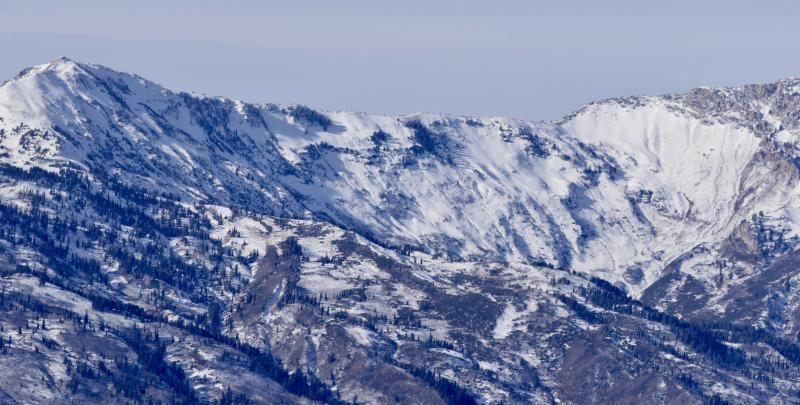
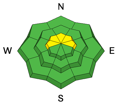
The avalanche danger is generally LOW, but a MODERATE hazard exists in wind-loaded terrain along the upper ridgelines. Increasing winds today may create fresh wind drifts, so it is important to evaluate the snow and terrain carefully, and watch for changing conditions.

Very thin snow cover exists across the zone so even getting caught in a small avalanche could drag you over rocks, stumps and other barely-buried hazards.
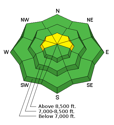
Low
Moderate
Considerable
High
Extreme
Learn how to read the forecast here
Special Announcements

For the 2017/2018 winter, we're excited to introduce the Utah Avalanche Center podcast, hosted by forecaster Drew Hardesty and produced by KUER's Benjamin Bombard. On the podcast, you'll find engaging stories, interviews, and lessons learned - all things avalanche, all to help keep people on top of the greatest snow on earth instead of buried beneath it - and easily found on ITunes, Stitcher, the UAC blog, or wherever you get your podcasts. You can find the first podcast, released this week here.

Drew also has written a blog entry "Those Who Cannot Remember the Past ....". This important discussion highlights the relationship between years with lean snowpack and an increase in avalanche fatalities. You can read it here.

Don’t know what to buy your favorite skier for Christmas? Discount lift tickets for Alta, Snowbird, Brighton, Solitude, Deer Valley, Snowbasin,and Beaver Mountain are now available, donated by the resorts to benefit the Utah Avalanche Center. Details and order information here. These make a great holiday gift and all proceeds go towards paying for avalanche forecasting and education!

Weather and Snow

As of 6 am, temperatures in the Ogden mountains are currently in the mid teens and winds are out of the southwest with gusts in the teens and low 20's mph.

Backcountry travel has been limited with total snow on the ground on shady, upper elevation slopes only around 12-18" and much of it weak sugary facets over a variey of crusts. Sunny slopes are a mix of small amounts of fresh snow covering crusty snow and bare ground. With a thin or non-existent snowpack at the mid and lower elevations, much of the snow that fell overnight Wednesday and overnight day landed on bare ground.

View the latest Ogden observations here.

Cutler Ridge and Ben Lomond east face on 12/19/17. Slopes like these that are covered with weak old snow are most suspect for avalanche potential.

Recent Avalanches

No avalanche activity was reported from Thursday.

Ad
Avalanche Problem #1
Wind Drifted Snow
Type
Location
Likelihood
Size
Description

Small pockets of fresh wind drifts can be found in higher elevation terrain, and these fresh drifts are of of greatest concern on slopes that have existing old snow cover, particularly northwest through east facing. These slopes hold a smooth, shallow coating of weak faceted surface snow on top of a hard crust. The crust has essentially raised the ground level and, because it is smooth and widely distributed, provides a nice bed surface for an avalanche to run on. Stay off of and out from underneath steep, wind drifted slopes to avoid this problem.

Increasing winds today out of the southwest may create a fresh batch of wind drifts along the upper ridgelines.

Even a small ride in steep terrain can cause serious injury due to rocks, stumps and generally thin snowcover.

Avalanche Problem #2
Normal Caution
Type
Location
Likelihood
Size
Description

Outside of wind-affected terrain, the avalanche hazard is Low. However, a very weak layer of faceted snow is sitting on top of the "glacial ice" layer, and is only waiting for a load for it to become active. The Kory Davis photo below nicely illustrates this layering. With snow and wind forecasted beginning later tonight, we may begin to see avalanching on this layer.


Additional Information

Increasing clouds with temperatures rising into the mid 20's at mid elevations with light to moderate winds. Along the ridges you will enjoy temperatures in the teens with northwest winds gusting into the 20's, with even stronger gusts into the 30's mph. Snowfall is expected overnight, with 3-6" of dense snow by later Saturday. After a short break, another shot of snow on Sunday Christmas eve, and into Christmas Day. Although no large storms are currently forecasted, fortunately the pattern looks favorable for the Ogden mountains with unsettled weather through much of this coming week.

General Announcements

To view our general announcements, click here.

This information does not apply to developed ski areas or highways where avalanche control is normally done. This advisory is from the U.S.D.A. Forest Service, which is solely responsible for its content. This advisory describes general avalanche conditions and local variations always occur.