Heightened wind slab avalanche conditions exist, and you could trigger avalanches today in exposed upper elevation terrain. Snow and wind tonight and this weekend will cause the avalanche danger to rise and become more widespread.
Evaluate the snow and terrain carefully and avoid steep drifted slopes.
The Tony Grove Snotel at 8400' reports 17°F and 28" total snow containing 80% of average SWE (Snow Water Equivalent). It's 10°F at the 9700' CSI Logan Peak weather station, with west-southwest wind currently blowing around 20 mph, and gusting to 36 mph. Only a couple inches of snow fell in the Logan Mountains with Wednesday's storm, and this did not affect the the avalanche danger much. We found nice snow (although it's getting very weak) and generally stable conditions yesterday in the Franklin Basin Area.
We expect the avalanche danger in the backcountry to rise just in time for the holidays, as new snow stacks up on weak preexisting snow. Very weak surface snow is widespread across the Logan Zone, and a layer consisting of sugary faceted snow directly above the solid Thanksgiving crust appears to be gradually getting weaker.
There is more total snow and better coverage in the central and northern Bear River Range and at upper elevations.
Shallow early season snow conditions exist, and hitting rocks or stumps is a significant hazard. Travel cautiously and keep your speed down.
The Tony Grove Road is not maintained for wheeled travel in the winter.
Avalanche Problem #1
Wind Drifted Snow
Type
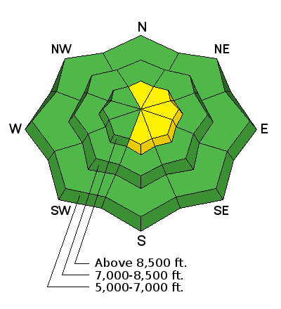
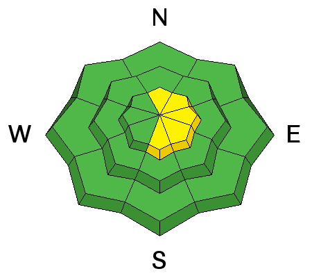
Location
Likelihood
Size
Description
Heightened wind slab avalanche conditions exist in exposed terrain, and human triggered avalanches are possible on drifted upper elevation slopes.
Avoid fresh drifts in steep terrain near ridges and in and around terrain features like gullies, saddles, rock bands, scoops, and sub-ridges.
Sluffs or avalanches entraining loose snow are possible in steep terrain.
A ride in even a small avalanche could be particularly dangerous now due to hard underlying snow and real potential for being dragged through rocks or deadfall below.
Additional Information
A series of weather disturbances will cross northern Utah this weekend into early next week while southern Utah will experience a warming and drying trend. A warm advection pattern will set up over far northern Utah, which will generate lift for considerable moisture streaming through the eastern Pacific ridge. Snowfall should begin in earnest around midnight.
There's a 20% chance of snow this afternoon. It'll be mostly cloudy, with a high temperature at 8500' around 23°F and 14 to 18 mph west wind.
Expect snow tonight, with temperature rising to around 23°F by early morning and 18 to 21 mph west wind. 3 to 7 inches of accumulation is possible.
5 to 9 inches of snow is possible on Saturday. Temperature will drop to around 20°F, and it'll be quite breezy, with 22 to 24 mph west wind gusting to around 40 mph.
General Announcements
Don’t know what to buy your favorite skier for Christmas? Discount lift tickets for Alta, Snowbird, Brighton, Solitude, Deer Valley, Snowbasin, and Beaver Mountain are now available, donated by the resorts to benefit the Utah Avalanche Center. Details and order information here. These make a great holiday gift and all proceeds go towards paying for avalanche forecasting and education!
Now is a great time to practice companion rescue techniques with your backcountry partners.
EMAIL ADVISORY:If you would like to get the daily advisory by email you will need to subscribe here.
Benefit the Utah Avalanche Center when you shop from Backcountry.com or REI: Click this link for Backcountry.com or this link to REI, shop, and they will donate a percent of your purchase price to the UAC. Both offer free shipping (with some conditions) so this costs you nothing!
Benefit the Utah Avalanche Center when you buy or sell on ebay - set the Utah Avalanche Center as a favorite non-profit in your ebay account here and click on ebay gives when you buy or sell. You can choose to have your seller fees donated to the UAC, which doesn't cost you a penny.
Remember your information can save lives. If you see anything we should know about, please help us out by submitting snow and avalanche observations. You can also call us at 801-524-5304, email by clicking HERE, or include #utavy in your tweet or Instagram.
This advisory is from the U.S.D.A. Forest Service, which is solely responsible for its content. This advisory describes general avalanche conditions and local variations always occur.