Forecast for the Logan Area Mountains

Toby Weed
Issued by Toby Weed for
Wednesday, December 20, 2017

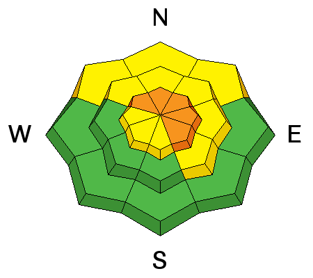
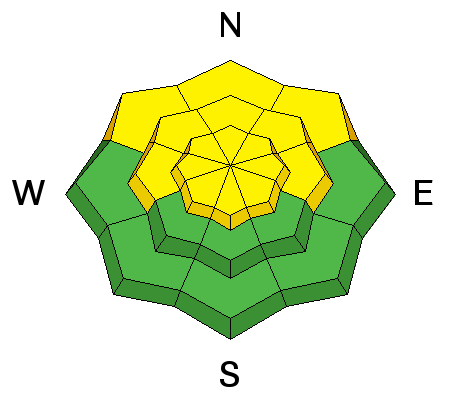
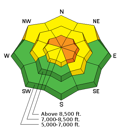
The avalanche danger will rise to CONSIDERABLE on some slopes in the backcountry with today's storm.

  • Heightened wind slab avalanche conditions already exist on drifted upper elevation slopes, and heavy snowfall and drifting from strong westerly winds will cause the danger to rise and become more widespread.
  • Dangerous avalanche conditions may develop and triggered avalanches could become likely in exposed terrain.
  • Evaluate the snow and terrain carefully, make conservative decisions, and avoid steep drifted slopes.
Low
Moderate
Considerable
High
Extreme
Learn how to read the forecast here
Special Announcements

Beaver Mountain opens up the lifts today, and you'll find great conditions.

Don’t know what to buy your favorite skier for Christmas? Discount lift tickets for Alta, Snowbird, Brighton, Solitude, Deer Valley, Snowbasin, and Beaver Mountain are now available, donated by the resorts to benefit the Utah Avalanche Center. Details and order information here. These make a great holiday gift and all proceeds go towards paying for avalanche forecasting and education!

Now is a great time to sign up for an avalanche class. Go HERE for a list of UAC classes.

Weather and Snow

It's mild and quite blustery in the mountains this morning in advance of a strong Pacific storm. The Tony Grove Snotel at 8400' reports 36°F and 26" total snow containing 83% of average SWE (Snow Water Equivalent). It's 29°F at the 9700' CSI Logan Peak weather station, and south winds picked up significantly overnight, currently blowing around 35 mph, and gusting to 58 mph. You'll need goggles today if you head up for opening day at Beaver Mountain, as snow is in the forecast all day. Snow and drifting from strong southwest and west winds will cause a rising avalanche danger in the backcountry, and dangerous conditions will develop on some slopes by evening.

  • There is more total snow and better coverage in the central and northern Bear River Range and at upper elevations.
  • Shallow early season snow conditions exist, and hitting rocks or stumps is a significant hazard. Travel cautiously and keep your speed down.
  • The Tony Grove Road is not maintained for wheeled travel in the winter.

Ad
Avalanche Problem #1
Wind Drifted Snow
Type
Location
Likelihood
Size
Description

An increase in south winds overnight created heightened wind slab avalanche conditions in exposed terrain this morning. Human triggered avalanches are possible in drifted upper and mid elevation terrain. The avalanche danger will rise and become more widespread during the day as a winter storm impacts the mountains and new snow stacks up on widespread weak preexisting snow. Drifting from strong southwest and westerly winds will rapidly build existing wind slabs and create new ones in exposed terrain. Dangerous wind slab avalanche conditions may develop by late afternoon, with human triggered avalanches becoming likely.

  • Avoid fresh drifts in steep terrain near ridges and in and around terrain features like gullies, saddles, rock bands, scoops, and sub-ridges.
Avalanche Problem #2
New Snow
Type
Location
Likelihood
Size
Description

More than expected snow will cause a heightened danger of storm slab avalanches. We've noticed and observers report increasing instances of localized shallow collapses and cracking. Very weak surface snow is widespread across the Logan Zone, and a layer consisting of very weak faceted snow directly above the solid Thanksgiving crust appears to be gradually getting weaker.

  • Sluffs or loose avalanches entraining new and old snow are possible in steep terrain.
  • Soft slab avalanches consisting of fresh snow and failing on weak surface snow are possible, even in sheltered terrain.
  • Avalanches could be triggered remotely, from a distance, or worse, from below.
  • A ride in even a small avalanche could be particularly dangerous now due to hard underlying snow and real potential for being raked through rocks or deadfall below.
Additional Information

The storm system over the Pacific Northwest will continue southeast into and then across Utah late this afternoon through Thursday. The associated cold front will enter northwest Utah this morning, then sweep southeast across the state by early Thursday. A second weather disturbance this weekend will bring additional cold air from Canada into the region.

  • Expect snow today, with 5 to 9 inches of accumulation possible by evening. High temperatures at 8500' should be around 31°F, but will drop during the day to around 20°F by evening. It'll be quite breezy with a 25 to 30 mph south wind, becoming northwest​ in the afternoon. Winds could gust as high as 50 mph.
  • Snow will continue into the evening, with an additional 1 to 3 inches possible. Low temperatures will be around 7°F and wind chill values as low as -7°F. North wind, 20 to 25 mph expected.
  • Tomorrow will be partly sunny, with a high temperature around 19°F and wind chill values as low as -14°F. 15 to 25 mph north wind is expected.
General Announcements

Now is a great time to practice companion rescue techniques with your backcountry partners.


EMAIL ADVISORY: If you would like to get the daily advisory by email you will need to subscribe here.

Benefit the Utah Avalanche Center when you shop from Backcountry.com or REI: Click this link for Backcountry.com or this link to REI, shop, and they will donate a percent of your purchase price to the UAC. Both offer free shipping (with some conditions) so this costs you nothing!

Benefit the Utah Avalanche Center when you buy or sell on ebay - set the Utah Avalanche Center as a favorite non-profit in your ebay account here and click on ebay gives when you buy or sell. You can choose to have your seller fees donated to the UAC, which doesn't cost you a penny.

Remember your information can save lives. If you see anything we should know about, please help us out by submitting snow and avalanche conditions. You can also call us at 801-524-5304, email by clicking HERE, or include #utavy in your tweet or Instagram.

This advisory is from the U.S.D.A. Forest Service, which is solely responsible for its content. This advisory describes general avalanche conditions and local variations always occur.