Forecast for the Logan Area Mountains

Toby Weed
Issued by Toby Weed for
Tuesday, November 29, 2016

Dangerous avalanche conditions likely exist at upper elevations in the backcountry. Avoid travel on or under drifted slopes steeper than about 30 degrees.

  • Very shallow early season snow cover exists in the backcountry, and hitting rocks is a serious concern.
  • You don't want to take a ride even in a small avalanche, as you could easily be injured with the shallow snow hardly covering up the rocks and dead-fall in avalanche runout zones.
Low
Moderate
Considerable
High
Extreme
Learn how to read the forecast here
Special Announcements

USU Outdoor Program is hosting a free Know Before You Go Avalanche Awareness talk on Wednesday night, 11-30-2016. more info go.. HERE

You are invited to our annual Pray for Snow fundraiser/party on Wednesday December 7 at the Italian Place in downtown Logan. For tickets and information Go...HERE


Weather and Snow

The Tony Grove Snotel at 8400' reports 17 degrees this morning and significant accumulations of new snow containing 2 inches of SWE (snow water equivalent) in the past couple days. Northwest winds moderated overnight at 9700' at the CSI Logan Peak weather station, and I'm reading 7 mph from the west-northwest and a chilly 9 degrees F. You'll find close to a couple feet of nice fresh powder at upper elevations in the backcountry. Careful because there is no solid base to keep you off the rocks, with all but due north facing slopes completely bare of snow before Thanksgiving.

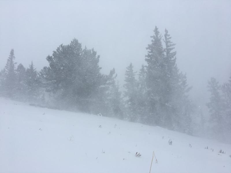
Periods of very heavy snowfall and strong wind in the past couple days certainly helped to fill in the rocky terrain


Remember, the Tony Grove Road is a busy shared use area, so you have to watch your speed around pedestrians and dogs. The road is not maintained for driving in the winter and conditions deteriorated significantly with the storm in the past couple days. If you attempt the drive in your 4x4, be prepared with shovel and winter survival gear. Beaver Mountain welcomes up-hill traffic this time of year as it helps to pack out the slopes, but you should consider it as "backcountry terrain" before they open the lifts to the public.


Recent Avalanches

No avalanches were yet reported locally, but Snow Safety operations throughout the Wasatch mountains yesterday reported widespread new snow activity from both ski cuts and explosives, up to 12” deep. In the afternoon, when the higher precipitation rates kicked in, natural avalanches were reported on a variety of aspects, including both northerly and southerly. In the Ogden area mountains, one triggered slide failed on the facets on the ground.

Ad
Avalanche Problem #1
Wind Drifted Snow
Type
Location
Likelihood
Size
Description

Dangerous wind slab conditions likely exist on steep drifted slopes at upper elevations, and softer storm slabs are also possible. Avoid travel in drifted terrain steeper than about 30 degrees.​

Avalanche Problem #2
Persistent Weak Layer
Type
Location
Likelihood
Size
Description

Deep slabs, failing on old faceted basal snow are possible on some smooth north facing slopes at upper elevations. Pay attention to signs of instability like cracking or collapsing.

Additional Information

A trailing cold northerly flow will continue through midweek. The next storm system will arrive over the Great Basin late in the week.

Today: Scattered snow showers. Mostly cloudy, with a high near 17. Wind chill values as low as -7. North northwest wind 18 to 20 mph. Chance of precipitation is 30%. Total daytime snow accumulation of less than a half inch possible.
Tonight: A 30 percent chance of snow after 11pm. Mostly cloudy, with a low around 9. Wind chill values as low as -7. West wind 9 to 18 mph. New snow accumulation of less than a half inch possible.
Wednesday: A 30 percent chance of snow. Mostly cloudy, with a high near 18. Wind chill values as low as -7. West wind 13 to 18 mph. New snow accumulation of less than one inch possible.
Wednesday Night: A 50 percent chance of snow. Cloudy, with a low around 13. Wind chill values as low as -1. West wind 11 to 13 mph. New snow accumulation of 1 to 2 inches possible.
Thursday: A chance of snow before 11am, then a chance of snow showers after 11am. Mostly cloudy, with a high near 18. Northwest wind 9 to 11 mph. Chance of precipitation is 50%. New snow accumulation of 1 to 2 inches possible.

General Announcements

The early season is a great time to refresh yourself and practice companion rescue techniques with your partners.


Check out Avalanche Canada's "Rescue at Cherry Bowl" story HERE

Between now and Jan 15th: Donate to the Utah Avalanche Center by shopping at Whole Foods Market Utah! When you visit any Utah Whole Foods Market locations, bring your re-usable bags, Whole Foods will donate a dime per bag to the Utah Avalanche Center - if you say DONATE my bag credit.

Remember your information can save lives. If you see anything we should know about, please help us out by submitting snow and avalanche conditions. You can also call us at 801-524-5304, email by clicking HERE, or include #utavy in your Instagram.